Entries to Win Afghan

Sign up to receive the Books Leaving Footprints Newsletter. Comes out occasionally. No spam. No list swapping. Just email me! jhyshark@gmail.com Previous gifts include a short story, a poem, and coupons. Add your name, and don't miss out!
Showing posts with label Michigan Midland to Mackinac Trail. Show all posts

Thursday, June 24, 2021

Back to Midland to Mackinac - Day 4

  This should have been a message right here. This person must have hiked yesterday, because there was serious rain on Tuesday which would have obliterated any footprints. You will notice this person did an out-and-back hike. footprints

My goal today was to hike from Grim Road to Guernsey Creek, hopefully cross it on a new bridge built by the Scouts, and reach Guernsey Creek Road.

A lot of the path was on two-track roads so I was concentrating on the plants. Here's a super-nifty one. This is a sedge. I know that most people don't care about sedges, but I love them, and this is a bit of a surprise. Tony Resnicek has IDed it coreectly as Carex folliculata. It has the highest Coefficient of Conservatism-: 10. And... It hasn't been found anywhere near the county where I was today. Gladwin County is very under-reported on botanical specimens. Carex Michauxiana

The dewberries are just blooming. It's too hard to tell them apart in the field without books, so I won't try to tell you which species. dewberries

So, I knew it was supposed to rain for about an hour, mid-day. It rained for three solid hours. Just in case you don't get wet enough in the rain, add wading through wet ferns to finish things off. Well, I got to Guernsey Creek. First off, let me show you another nifty plant. This one isn't particularly special, but I like it. This is Common Bur-Reed, Sparganium eurycarpum. The stems are hollow and triangular. common bur reed

And the flowers are spiky balls on a zig-zag stalk. Just fun- like a plant with a sense of humor. common bur reed

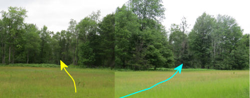
Well, now I'm standing at the edge of the creek. Of course, I've walked an extra mile because there was no turn blaze for where to leave the 2-track. It's pouring. I'm in waist-deep weeds. Here's the creek. I'm in the right place. There's a blue blaze on the stump over there, and one on the next tree too. See a bridge? Guernsey Creek

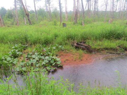
The answer is "yes," however, it's not what you think. The Scouts actually built two bridges. The first one was a large log with the top flattened and a hand rail added. But that got swept sideways during a high-water event. The second one, not as fancy, apparently has now been taken completely downstream. Anyway, look hard and you can see the first one in the grass over there. Notice the cable railing, and then you'll see the end of the log. Guernsey Creek

I was only about a mile from the road I was aiming for, but I would have had to try to cross the creek, and then again coming back, so I turned around.

Now we get to the embarrassing part. There was only about a half mile of woods trail to connect a couple of those 2-tracks. The blazes were faded and hiding, but I made it through OK, and added a few pieces of flagging tape where I thought I might need it going back. On the way back, I lost the blazes twice, and I re-found them twice. That is a matching set, so we should be good, right? Nope, somehow I went back the way I had come and ended up at Walter Road which I knew pretty well by then, having already crossed it twice. It's still raining. I'm soaked and hungry, but don't want to stop and eat in the rain. I know where I am. And I know I won't get turned around on the road. So, yup, I walked around to my car. 4.3 miles around, being attacked by so many deer flies that I got out my head net. But at least it stopped raining then.

So I had a nice wet 9-mile hike.

Midland to Mackinac Trail, Gladwin County, MI, Grim Road to Guernsey Creek, and road walking. 9 miles

See Back to M2M- Day 3

Wednesday, June 23, 2021

Back to Midland to Mackinac - Day 3

  It was a pretty amazing day, but I'm beat. I hiked 14 miles, but only 5 of them were actually on the Midland to Mackinac Trail. Those miles were so difficult that I chose to take a longer road walk back to my car in both the morning and afternoon. In both cases, I walked the longer road miles faster than the trail miles.

The temperature was perfect- in the 70s, and the only wildlife I didn't like was the deer flies. But I kept my hair covered with a bandana and foiled their dive bombling.

I didn't get pictures of a lot of things, but I got a nice variety. Here's a Red-spotted Purple Admiral. I also saw Fritillaries, and I another orange one that I couldn't ID on the fly (literally). Red-spotted Purple Admiral

I guess the next spotting was a Ruffed Grouse. It did not fly up, but did the pretend broken wing thing, so I suspected a nest nearby. The baby had fledged! I use the singular because I only saw one, but it flew right up beside mom. Mom landed and made a strange mewing sound. I've never heard that from a grouse before.

After that, a Woodcock flushed up right in front of me!

I loved the tamarack with the purple cones just forming. tamarck cones

This section of trail was a piece that was totally flooded two years ago, so I hadn't seen any of it. This was from Estey Road north to Guernsey Creek Road. I made it through, but it took me 2.5 hours to hike 2.8 miles. But it was wild and quiet and adventurous. I added quite a bit of blue flagging tape to help other hikers find their way with a little less trouble. Someone had been through recently enough to leave broken ferns. That helped me a few times. clearing in woods

Don't think that the road walks to return were so bad. Most were quite pleasant. This is Eastman Road. Eastman Road

After that, I decided to go back to the southern end of the piece I did on Monday. It seriously needed some additional flagging tape. I only found the trail on Monday because I'd spent a ton of time two years ago exploring all the places the trail was not. Perhaps foolishly, I decided to hike in from the next road south to see that section again. Hoo boy. It skirts a big wetland with treacherous footing, and then I had to hunt for blazes a few times. One benefit of that was finding this huge Black Oak. There are quite a few big ones in this section. The big oak also served as a landmark as I hunted for a blaze. large black oak

I went in as far as that infamous clearing and hung long streamers of blue tape that can be seen from each exit of the trail. Then I contemplated if I wanted to hike the two trail miles back- They had taken me over an hour to hike, and I'd gotten pretty wet getting around the wetland. I decided to do the 3 mile road walk back, which was also a bit of an adventure. The first mile was on a really old woods road. I briefly thought it was going to disappear into a huge marsh, but it did curve around that. Then it came out to the "real" road on private property. So, it's probably no longer a public road. Fortunately, I didn't get yelled at. After that it was a piece of cake to get to the car.

Found this cute little Northern Water Snake in the middle of the road. Someone needs to explain to him that he likes water. Anyway, I scooted him to the edge so that he might live long enough to find some water.
Northern Water Snake


This lovely wetland with Bullhead Lilies didn't slow me down. What's a little unusual about this is that the water must have dropped after the lily pads grew. The leaves are standing quite upright instead of floating on the surface. bullhead lilies

I did get held up there for a few minutes taking a picture of the Twelve-Spot Skimmer dragonfly. twelve spot skimmer

I think I earned my dinner today! I made a new skillet meal that will last me a couple of days. dinner with noodles in a bowl

Anyway, I did 9 road miles and 5 trail miles. Tomorrow will be a little less ambitious.

Midland to Mackinac Trail- Estey to Guernsey Creek Road, and Mohawk Road to north of Rose Lane, and road returns. 14 miles

See Back to M2M - Day 2

Tuesday, June 22, 2021

Back to Midland to Mackinac - Day 2

  Hi there! Did you have a nice day? I did.
yellow smiling art man


In the morning, I hiked a section of the Midland to Mackinac Trail that I did not even attempt to describe in the first iteration of the guidebook. My friend, Jerry, led me though it in 2018 because he said I'd never find it on my own, and I think he was right. However, now you can find your way through that section.

It's rough in a couple of places, but do-able. This portion that follows an old two-track was really pretty. But sometimes I was wading through ferns that were almost to my armpits, and there was a stretch of about 100 yards that I thought might be the end of the hike. But I kept climbing over downed trees and squishing through soft spots, and I did find the next blaze, and I didn't break an ankle. After that, it got better. (Oh yeah, I did miss a turn that wasn't marked and found a really old blaze that hadn't been removed, but eventually I figured that out and got back on the right track.) Midland to Mackinac Trail

As I said, this is a Boy Scout trail, and there are these nice signs at most of the major road crossings. Midland to Mackinac Trail sign

And in the woods, you'll find a mixture of blue rectangular blazes, arrows, diagonal marks, the normal DNR hiker/skier trail trapezoids, and some of these- special DNR trapezoids made for the Boy Scouts. Midland to Mackinac Trail Boy Scout marker

I will say that even though a lot of the trail is rough, there are almost always bridges at the creeks. This crosses Wheeler Drain. It's listing a bit, but it was sturdy. Midland to Mackinac Trail bridge

The portion I hiked today was all west of route MI-30, with crossings at each end. So, I'm not a complete dope. I walked back to my car on the road to complete the loop without having to fight my way through the difficult parts again. And that was fun too, because I found the yellow happy guy, and also this interesting location. This is an arm of the Tittibawassee River that obviously had much more water in the not-too-distant past. Remember when Sanford Dam failed in 2020? This is one of the areas, although far upstream, that was affected.

Jerry says the dam is being rebuilt, so perhaps all these homes will once again have waterfront properties. Right now, not so much! docks high and dry above water level

I got back to the car just before the rain started. Talk about timing! It rained all afternoon. But I had planned to spend some of the time with Connie and Jerry talking about the sections that would be best for me to re-hike. I knew I couldn't do everything on my list this week anyway, and they helped me decide which ones probably haven't been fixed yet. So now I have a plan for the rest of my time here that is likely to be productive. And we also had a chance to visit, which is nice because they are also good friends. They are really busy this week with special meetings at their church. Otherwise they'd be more involved with my trail adventurees.

I was thinking I might do a short hike in the late afternoon, but another heavy thunderstorm rolled in, so, hey. we just visited some more.

Midland to Mackinac Trail, Gladwin County, MI. West of M-30 and south of Ritchie Road. 4.2 mile loop

See Back to M2M- Day 1

Monday, June 21, 2021

Back to Midland to Mackinac- Day 1

  I've teased you about where I planned to go... now for the true story. I am on the other side of the state, rehiking parts of the Midland to Mackinac Trail. The plan is to hike the pieces that have been fixed and update the guidebook. Today, I did one short piece that I never did connect in 2018, even though I tried it from both directions. Today, I succeeded in connecting.

Let me remind you that the M2M is a trail that the DNR (which owns most of the land it traverses) does not want tools put on the treadway. This recreates a Native American route, and they want it kept primitive. What that mean is that you pretty much have to walk from blaze to blaze, stumbling most of the way. You can NOT just hike along. This short section is actually on an old road, so it was pretty smooth under the ferns. That didn't last long. Midland to Mackinac Trail

I was hiking in from the north end this time, and made it to right where I lost the trail in 2018 and spent 20 minutes looking for another blaze with no luck. But this time, I found a small piece of flagging tape. That confirmed you are supposed to push your way through a shrubby strip of wetland, and once past there I did find another and another blaze, until I came to my goal- this clearing.

This was the 2018 real problem. I was hiking from the south and came to this large opening, and could not find where the trail exited at all. I went straight across, and eventually got out to a road, but it was not correct. So today, I very carefully paid attention to where I entered the clearing from the north. Because there are still no blazes.

Then I walked all around the edge of the clearing to try to find where the trail comes in from the south- in other words, where I lost it the other time. And I did find that. This composite picture is taken from the point where you enter the clearing from the south. What I did in 2018 was folllow the yellow line as a guess. As it turns out, what you need to do is follow the blue line. Midland to Mackinac Trail

That was definitely the best find of the day. Second best, and certainly more interesting to you folks was a baby bird. Maybe a brown thrasher. I'm not sure. Not really scared of me- we just watched each other for a bit. baby bird baby bird

Made it back to the log church where I started, 2 hours and 10 minutes later. Only 3 miles of hiking. I had sort of forgotten how hard it is to hike with no treadway. Plus hunting for blazes. But I'll be able to fix this section of the guidebook. That will be my goal each day this week- not speed. log church

And where am I? I'm parked in the yard of some friends for a few days. Sunny is happy. I am happy. fiberglass trailer

I had a cozy little dinner. Interesting that it's 52 degrees, and yesterday it was almost 90. I do like this better, but it's been a few weeks since I needed a sweatshirt! camp dinner

The only other news is that I had a terrible time waking up this morning and left home way later than I had hoped, but it was fine. I hiked the piece of trail I had planned, and succeeded at my goal.

Midland to Mackinac Trail, Cedar Lake Road to past Rose Lane and back. 3 miles

See Rest and Replanning Again

Monday, October 22, 2018

Midland to Mackinac Hiking Trail Guide

 
The first attempt at a Midland to Mackinac Hiking Trail Guide is ready to go. I decided that the effort is worth $4.99 which is a little higher than I was first thinking, but still quite reasonable.

Midland to Mackinac Trail Guide
It's available only from Smashwords, and can be had in HTML (so you can read in a browser), as a pdf (so you can print a paper copy of the whole thing), and in two ebook formats: epub and mobi (so you can view it as an ebook if you wish, although I'm unsure how good the maps will appear on any given device. You should be able to expand them to see particular sections larger).

The first 15% can be viewed without a purchase, which allows you to see the introduction, definitions, legend, one segment of description and a couple of maps. This should give people a chance to decide if they think it's worth a purchase.

Go to Smashwords to see the Midland to Mackinac Hiking Trail Guide.

In other news: I did a bunch of stupid housecleaning today, and trimmed back the rose bush I hate 51 weeks of the year.

See Conclusions about the Midland to Mackinac Trail Hike
if you like this blog, click the +1   or

Like This!

Wednesday, October 17, 2018

Conclusions About the Midland to Mackinac Trail

 
A lot of you readers have stuck with me for almost two months, since I announced my intention to hike the Midland to Mackinac Trail. Now, I've actually done it, but not much at all in the way I planned. That's OK. The trip cost me a lot more than I expected. That's OK. I wanted an adventure. I sure got that!

Midland to Mackinac Trail sign

Let's talk about the quality of the experiences one can find on this trail route. First of all, recall that this is an attempted approximate re-creation of a Native American pathway. As such a transportation route, a lack of elevation change was considered a good thing. Therefore, with only a couple of exceptions, the M2M Trail chooses to follow valleys rather than search out the peaks.

A lot of the route is on old two-tracks, woods roads, snowmobile trails, etc. For the most part, I don't think that really diminishes the experience. Some of the ATV trails were churned up sand which made really difficult walking. Those were not much fun, but they were a minority of treadway experiences. Here are two examples you've not seen before of the kind of "roads" the trail often follows. These are definitely appealing to me.

Midland to Mackinac Trail

Midland to Mackinac Trail

This area of northeast lower Michigan has a backcountry and remote feel to it, similar to the western Upper Peninsula, but much closer to where a lot of us live. Although most of it is criss-crossed by two-tracks, it's hard to miss the "wild" feeling of the tall spruce. Vast stretches of jackpine forest are carefully protected for Kirtland Warblers which helps keep civilization at bay. Except for very recent cuts which can be unsightly in their raw-ness, even the logged areas are interesting because they open up the landscape to give longer views of the topography.

Midland to Mackinac Trail trees

Most of the lakes along the route are not encircled by cottages or cut by motor boats. That's largely because much of the trail is in State Forests. I almost didn't realize how unusual it would be where I live to find so many small lakes with little or no human influence.

Midland to Mackinac Trail Stoney Creek Pond

Midland to Mackinac Trail Cornwall Flowage

Although this was the most significant footbridge I encountered, the trail either uses road bridges or has good structures at river and creek crossings. Except for the very smallest (where there were at least log bridges), there were solid bridges. The only places I had to wade were a lot of deep puddles which probably are not there when things aren't so wet, and some beaver flooding the last day before I joined the rail trail. (I'm not counting that fiasco on day three in the real beaver flooding, since the trail actually had been re-routed away from there).

Midland to Mackinac Trail bridge

I think this trail has the potential to take some pressure off some of the other popular trails in the state. For those who prefer loops over everything else, there are abundant old two-tracks that would probably create some nice loops. I haven't measured it, but there is certainly a loop that could be made with the High Country Pathway that would be shorter than its 80 miles.

Since so much of the trail is in state and national forest, dispersed camping is allowed. With a little research to be sure you were on public land, any number of short trips could be planned- one doesn't have to do all 210 miles.

Now for the difficult part. I lost the blazes on 12 of the 25 hiking days. Four of the hiking days were rail trail and another all roadwalk. That means that 12 of 20 days where there was single-track trail, the trail was impossible to find. There were two other times where I just happened to guess right as to which way to turn at a major junction with no blaze. There were several places where I managed to find blazes and make my way through, but it might have been luck as much as skill. In all fairness I should say that at least 4 of the problem areas have already been fixed.

This is a trail maintained by Boy Scout troops with a bit of help from some dedicated adults. But it needs more help. And it needs more hikers. If it were used more, at least there would be a visible treadway to follow, which was not always (often) the case.

My guide will be ready to go in just a couple more days. It's very close to complete. I hope some people will venture forth and give sections of the Midland to Mackinac Trail a chance. It would be awesome if some people would volunteer to help do some clearing and blazing as well.

See Sticking My Foot Out
if you like this blog, click the +1   or

Like This!


Tuesday, October 16, 2018

Day Twenty-Six - Midland to Mackinac Trail

 
Today was exquisitely inefficient, and possibly stupid to bother to do, but it completes the project! Om and I were gone 12 hours, almost to the minute, so that I could hike maybe 9 miles.

Give Om a warm car and chances to take pictures of pretty leaves and he is happy.

person taking pictures of fall colors

I'd already driven this piece once, and drove it twice more today before I walked it so Om could see where he needed to go wait for me, and then I finally walked it. But there are always things to see on foot that escape at car speed, even when going very slowly on poor roads.

The day was absolutely lovely. Since I hiked so many wet days this felt like a real gift, and a nice ending.

dirt road with a tunnel of yellow autumn trees

It was chilly at first, but it warmed and the sky was gorgeous.

blue sky above aspen trees

The art of a beech tree decorated with white pine needles.

yellow beech leaves with white pine needles

More leaf art- I call this the super-pressed leaf technique. Materials: 1 muddy road, fallen leaves, multiple trucks.

leaves compressed in muddy road

Sure, it was a roadwalk, but there was nothing shabby about the scenery. It was a gorgeous bright, breezy day with golden leaves skittering out in front of me and swirling around my shoulders.

back road with fall colors

On the way home, Om and I stopped in Gaylord and ate at the historic Sugar Bowl. We didn't have a chance to do anything for our anniversary in August (50 years), so we celebrated today.

Sugar Bowl restaurant in Gaylord

I had a Reuben and Om had a bleu burger. Who are those old people?!

people eating at Sugar Bowl restaurant in Gaylord

Total miles today: 9 (which was really 8, but I needed to add one on to the day I came into this point from the south, so I'm calling it 9). Total miles for the trail: 215.5 (estimated, but the official estimate is 210, so not far off). Total miles actually walked to reach that goal: 299 or thereabouts!

I walked either THE trail, or some alternative to connect the points where trail was lost. In some cases I went back and picked up the missing sections from the other direction.

There will be one more post about the Midland to Mackinac Trail, with some conclusions about this adventure. Probably tomorrow.

See Day Twenty-Five
if you like this blog, click the +1   or

Like This!