Entries to Win Afghan

Sign up to receive the Books Leaving Footprints Newsletter. Comes out occasionally. No spam. No list swapping. Just email me! jhyshark@gmail.com Previous gifts include a short story, a poem, and coupons. Add your name, and don't miss out!
Showing posts with label Buckeye Trail. Show all posts

Tuesday, March 26, 2019

Buckeye Trail Patch

 
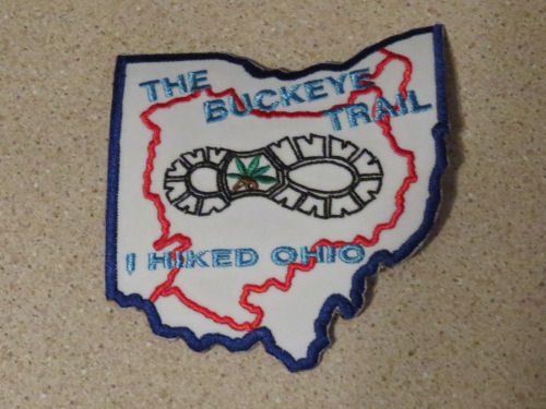
It is late and I am tired. I'm going to do a quickie post to show you that I finally received my patch for completing the entire Buckeye Trail (finished in May 2017).

I love patches!

Buckeye Trail completion patch

In other news: It was a busy day. I worked on the book in the morning, and on Long Distance Hiker recognition in the afternoon. Then I walked 3 miles, had writers' group and did grocery shopping. I'm ready for bed.


See Buckeye Trail- Last Day
if you like this blog, click the +1   or

Like This!


Thursday, May 24, 2018

Buckeye Trail Circuit Hikers

 
One of the neat things about trail conferences is talking to other people who have hiked long distances. There are more people who have hiked all of the Buckeye Trail than those who have hiked all the North Country (makes sense- the BT is "only" 1440 miles)

I like to take pictures of me with other hikers. Call it ego. Call it a club. Call it fun. Anyway... here are some.

First up is Andy Niekamp, who also wrote a book about his adventure called Captain Blue on the Blue Blazes. I had read and really enjoyed his book, so I was happy to meet him.

Buckeye Trail hikers Andy Niekamp and Joan Young

These three people are "old" friends. Ruth and Dan Dorrough and I are now the only three people who have hiked all the North Country Trail, the Finger Lakes Trail, and the Buckeye Trail. In between them is Randall Roberts who has completed the BT, and is now working on pieces of the NCT. I failed to put myself in a picture with them. Next time. (Although I have lots of pictures with Dan and Ruth)

Buckeye Trail hikers Ruth Dorrough, Randall Roberts, Dan Dorrough

You've heard about this person before. It's C.W. Spencer. Ester and I stumbled upon him and wife Bonnie hiking in northern Ohio in the fall of 2016. His book about his BT hike is also a book about grief, called Hiking Without Dave. Excellent. He also led the Sunday morning worship service at the conference.

Buckeye Trail hiker C.W. Spencer

These three people are also circuit hikers. I thought I hadn't met any of them. Wrong! The couple on the left are Chuck and Beth Hewett. They have written Wandering Ohio, which is a journal style account of their hike. Beth remembered talking with Marie and me in 2014. We had a chance encounter in northern Ohio! But this was definitely the first time I'd met Mei Ling (on the right). She is now off hiking the Appalachian Trail.

Buckeye Trail hikers Chuck and Beth Hewett and Mei Ling Liber

Long-distance hikers just naturally have things in common. It's a great informal "club" to belong to.

In other news: I was good- I stayed home and did stupid odds and ends that needed to be done. I mowed the rest of the grass and my trails, which I then hiked in the early evening. I wrote a little bit. I got the recycling sorted. I think I may go to bed with a book.

See NCT End to Enders
See Spirit Mountain
if you like this blog, click the +1   or

Like This!


Thursday, May 3, 2018

Buckeye Trail Surprise

 
We know I've already hiked all the Buckeye Trail. Sure, some parts have changed, but I don't think this one has. I remember rocks, but I must not have been paying attention. (Walking in my sleep?) The rocks on this section were amazing. Not part of a park, but they must be on public land since there was also a bridle trail.

Buckeye Trail Ohio near Hocking Hills

First, we climbed to the top of a wooded ridge with a nice view over the valley. The spring trees are just getting to the phase I love best.

Buckeye Trail Ohio near Hocking Hills

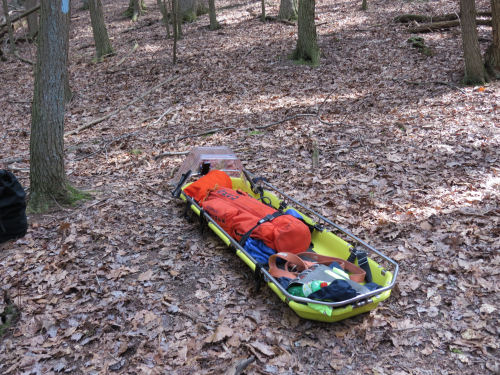
Then we descended to the tops of some rocky cliffs. This area is known for good rappelling spots, and we came across a statewide training session for rescue teams. There were about 15 people in the group being taught how to get up and down the cliffs with rescue baskets.

Buckeye Trail Ohio near Hocking Hills

Buckeye Trail Ohio near Hocking Hills

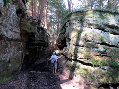
Just a ways beyond them, we turned a corner and began to descend through a crack in the rocks till we were down in front of the rock faces.

Buckeye Trail Ohio near Hocking Hills
In some places we were walking through narrow hallways where the rocks had split.

Buckeye Trail Ohio near Hocking Hills
This was the most amazing spot, I thought. The sandstone was weathered and flaking with the ocher color showing through in rounded curves and the trail going right along the base of the cliff. Hard to believe this is Ohio!

Buckeye Trail Ohio near Hocking Hills
Then we went to a place called Butterfly Ridge. It's a privately owned conservation area that is working to create habitat to attract and support native butterfly and moth populations. You take your chances on what you might see on any given day, but the owner gives you an idea of what to look for. We saw three pipestem swallowtails, but I didn't get any pictures. It's a neat place if you are in the area.

Total miles hiked today about 6.5

After a nice dinner we drove around Lake Logan.

Lake Logan Ohio near Hocking Hills

Tomorrow, Marie says goodbye and heads home. I can't put a good spin on that, but our time together has certainly been wonderful.

See Cantwell Cliffs and Clear Creek
if you like this blog, click the +1   or

Like This!

Tuesday, May 1, 2018

Ash Cave, Long Tunnel, Old Man's Cave, Devil's Bathtub

 
Today was exceptionally fine! We (mostly) followed the routes of the Buckeye and North Country Trails through the Hocking Hills State Park from south to north. I previously hiked this about 20 years ago from north to south, and the trail is very different now. My previous hike was the year after some big floods when all the bridges had been washed out. We forded the stream a lot that year. I'm pretty sure the route through the park has even been changed in a few places. There was no trouble following it this year, and the day visitors were everywhere.

I had to pick only a few of the best pictures, but you'll get the idea.

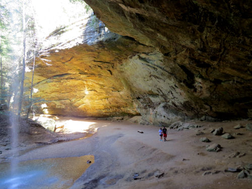
From the south, the first big formation was Ash Cave, so named from piles of ashes found by early explorers and supposedly left by Native Americans. I like that there are a couple of people in the picture, so you can get a sense of the scale.

Ash Cave, Hocking Hills, Ohio

Only the most spectacular places have names. This is just a slightly overhung cliff with water falling over it. With the sun through the water, it was beautiful.

 Hocking Hills, Ohio

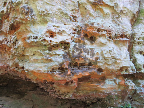
Nearly everywhere, the Blackhand sandstone is honeycombed from water percolating through the rock. The red color is because iron oxide serves as the adhesive agent that helps hold the sandstone together.

honeycombed rock, Hocking Hills, Ohio

The biggest surprise of the day was a little side trail to a feature called Long Tunnel. All weekend we'd been hearing about features, studying maps of the park, and had never seen a thing about this. Well, "tunnel" sounded intriguing. First we began by switchbacking up the rocks on stone stairways.

Long Tunnel trail, Hocking Hills, Ohio

Next, there was a curved metal staircase taking us nearer to the top of the cliff. The remainder of the climb was through a tunnel carved in the rock. I wanted to know more about it, but there was no sign to explain if maybe there was an early small opening made by water that was enlarged for people, or what.

Long Tunnel, Hocking Hills, Ohio

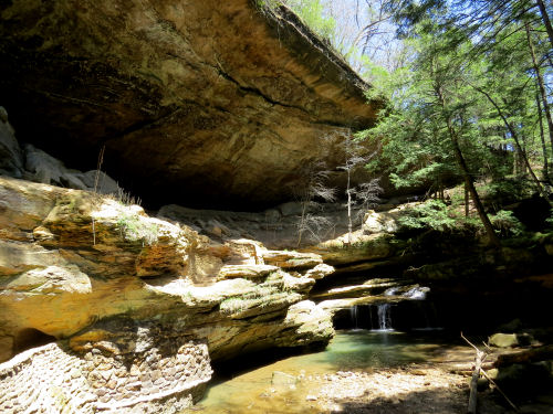
Shortly, we returned to the BT, NCT routes and arrived at Old Man's Cave. A hermit lived here after the Civil War, which is where it got the name. These are all hanging cliff caves where the sandstone has eroded and undercut the edge. This one is really large. It was hard to get a picture that showed it well. This view, at least, shows the small waterfall below and about half the cave. On the far lower left you can see the exit from the short tunnel that takes you down from the cave.

Old Man's Cave, Hocking Hills, Ohio

Another tunnel, that wasn't part of the trail when I hiked it, leads you up toward the parking lot. I love tunnels!

Ash Cave, Hocking Hills, Ohio

We crossed the creek on yet another bridge, as much a piece of modern art as a functional bridge, with the A-Frame Bridge across the gorge high above. Even though it was an anomaly, I actually liked the abstract shapes against the curves of the natural rock.

 Hocking Hills, Ohio

Our last feature of the day was Devil's Bathtub, a small swirled pool made by rocks whirlpooled in the stone. This was more like Watkins Glen, New York, than Ohio.

Devil's Bathtub, Hocking Hills, Ohio

The day was getting hot, but the trail in the gorge was cool. We ate some lunch and then went for the important stuff- ice cream.

We came back to our "home" at Cardinal Lodge and have another nifty day planned for tomorrow. We are supposed to get one more nice day.

P.S. At long last, I'm getting started on this year's Hike 100 Challenge, so I've got my first five miles. I know...pathetic, to not start till May, but I'm not worried.


See Rock House and Conkle's Hollow
if you like this blog, click the +1   or

Like This!


Sunday, April 29, 2018

TrailFest 2018

 
Just a couple of pictures tonight. We are getting sorted out and I have to write my newspaper column yet. The joint Buckeye TrailFest and North Country Trail Celebration began Wednesday night and ended today, at Camp Oty'Okwa near Logan, Ohio.

Some of the treats were Buckeye State cookies with a blue blaze. Perfect.

cookie in the shape of the state of Ohio with a blue Buckeye Trail blaze

The camp is owned by Boys and Girls Club, and is a really nice facility. This is the Activity Hall.

activity hall Camp Oty'Okwa

In the dining hall there's a beautiful double-sided fireplace. The speaker is our National Park Service Superintendent, Mark Weaver, explaining something.

dining hall Camp Oty'Okwa

One afternoon we had a gear demonstration by a representative from Backpacker Magazine. He was a good guy and interacted with us all weekend.

Backpacker demonstration Camp Oty'Okwa

Marie and I camped for the duration of the conference, but had decided to get a motel for tonight. However, when we asked the camp director where we might find a nearby motel that wasn't a big chain, he said we could stay in one of their cabins (until Wednesday) for a very reasonable price- only four dollars more than camping at the state park! Well. We are not stupid. We have heat (freezing nights here), shower, hot and cold running water, a kitchen, bathroom, and internet.

Gotta stop now and write, but I have lots of neat stuff to share.

See 2017 NCTA Celebration
if you like this blog, click the +1   or

Like This!


Sunday, May 7, 2017

Buckeye Trail Completion, Day 7- End

 
Although this was the last day, and only 9.4 miles, we still managed to get in some superlatives. But first things first. It's always sad to break camp. Nothing left but a yellowed square where the tent was. And the trash can.

tent site

The redbud was beginning to fade, but the dogwood was coming into its full beauty.

dogwood lining road

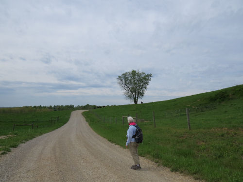
There is something about the curve of a lonely road that just calls to me. The loose gravel and my feet aren't friends, but that's another story.

curving road

We crossed the Muskingum River, a large tributary of the Ohio River at Stockport. The building across the way is a mill, now restored as an inn.

Muskingum River at Stockport

If you remember the "lesson" of yesterday, we've now reached the largest waterway in the area, so there's no where to go but up (unless you switch to floating!). The road curved back up a hill from the river at a ridiculous angle, climbing 900 feet in 0.7 mile. (Actually it's the tallest one to the left of the mill.)

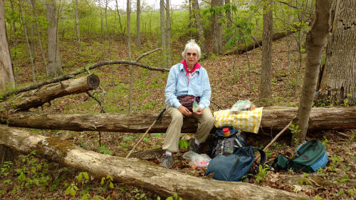
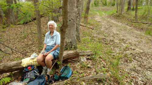
At the top we did have a nice surprise. We knew there was going to be a little more trail that was "off road." It began here. We had assumed from the looks of the map that this was simply an abandoned road. Actually that was true, but it turned out to be more like a farm lane, and was very pretty (no gravel either!). We found a comfy log for lunch. I'm not sure why Marie looks mad. We were having a wonderful final day. There were clouds threatening rain, but we thought we might beat it, and if not... there was a warm car ahead.

lunch site

lunch site

At the bottom of that road we forded Scott's Run.

Scott's Run

On the one last piece of trail there was a register box, about two miles from the completion of my hike. Nice timing!

signing trail register

But, just to keep me humble, there was one final indignity- the worst hill of the entire hike on a road with loose gravel. We crossed the next ridge and dropped down to Aldridge Creek. Then we climbed 660 feet in 0.4 mile. Whew! But it made the ending feel so deserved!

Because the Buckeye Trail is a loop, there is no big deal end point. There was just a road sign where I connected to a previous hike at the corner of Lightner Ridge and Tabor Ridge Roads.

Lightner Ridge

Lightner Ridge

Please notice that we beat the rain! (But not by much) We immediately headed for Stockport in search of pie and iced tea, which we found at C-J's Restaurant. The pie was strawberry rhubarb, quite good.

pie

Thus I have completed the entire Buckeye Trail including the "Little Loop" and the "Wilderness Loop" and the spur in to Cincinnati. I haven't checked my total miles, but it's something around 1450.

This is plenty enough for today, but I'll share flowers and some other post-trip details in the coming days.

Happy hikers!


See Day 6
if you like this blog, click the +1   or

Like This!


Saturday, May 6, 2017

Buckeye Trail Completion, Day 6

 
Now we were moving farther away from our camp each day, and putting the cars out took longer again, but even so we were hiking at 10:20.

This was our last day in the AEP lands. Those last two off-road miles were characterized by small steep hills with little creeks between. We crossed Onion Run, the collective for the un-named streams, twice while still in the woods. And we crossed a lot of the little trickles. No big deal, but think down and up.

steep valley

When we reached the road we were to join at the end of the AEP property, it continued along Onion Run. The day was heating up, and we were glad to sit in the shade beside the stream for a rest with the cool air rising from the water.
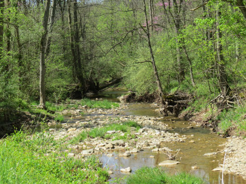
Onion Run

In fact, we crossed Onion Run three more times on road fords. These seem to be characteristic of southern Ohio on streams that are generally small. I suppose the protocol is that people know not to drive through if the water is really high.

road ford

I also found it amusing that although this seemed to be one of the most primitive roads we walked, it was the only time on the entire trip when I had 5 bars of service on my phone. Must have been a tower nearby!

Here's an oddball sighting. This tree stump has "stuff" oozing all over it. I think it's a Gelatinous Woodcrust fungus, but am open to correction.

gelatinous woodcrust
Want to see that closer? Too bad if you don't.

gelatinous woodcrust

All those valleys close together means there are multiple streams through the area. This road bridge was a picturesque way to cross Meigs Creek.
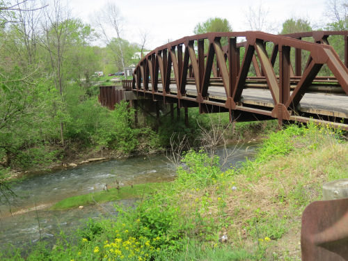
Meigs Creek bridge

We turned right just across that bridge and crossed a non-picturesque bridge on a state highway over Perry Run. At that point we reached the lowest elevation of the day. Read largest waterway. Also read, next thing we did was go UP. And I do mean up. (But, even so, it was not the steepest climb of the hike. Stay tuned till tomorrow.)

The next three pieces of road were goofy. At least on the map. There are no roads (or trails) that go over the next two ridges. So we walked west around a "toe," then back east for a mile around the next toe, then back west three miles till we could join a road going south. Forward progress, maybe a mile as the crow flies.

We saw this cooling tower and assumed nuclear plant, but learned later that it is a large coal-fired power plant operated by AEP.

power plant

Our final mile of the day was a gentle walk along Olney Run. We were glad of that. The day had heated up to 86 degrees, and we weren't used to those temperatures yet! There were little rills and waterfalls. We enjoyed watching one during our final break of the day, although we didn't go to the water as all the access was through poison ivy.

The ivy was our biggest enemy on this hike. It was at the deadly invisible stage where there are three folded maroon leaves on a 6-inch twig. Unfortunately, this stage is extremely virulent so we have to be vigilant and wash often. We were either careful or lucky because neither one of us got more than a few dots. We consider this a major success.

Olney Run

We reached the car at 3:15, and this turned out to be our longest time. I think it was due to the heat which made us decide to take that extra afternoon rest stop.

Wednesday, April 26. Stockport map, points 5-12, 10.1 miles. Trip total at this point, 53.8 miles. We also passed the junction where the now official southern end of the Wayne NF loop comes back to meet the Buckeye Trail. But I had to walk a bit farther to complete the trail where I had veered off to the east.


See Day 5
if you like this blog, click the +1   or

Like This!