Entries to Win Afghan

Sign up to receive the Books Leaving Footprints Newsletter. Comes out occasionally. No spam. No list swapping. Just email me! jhyshark@gmail.com Previous gifts include a short story, a poem, and coupons. Add your name, and don't miss out!
Showing posts with label geology. Show all posts

Friday, August 23, 2024

Celebration 2024 - Friday

 Marie, Diane and I just took a little walk out to the St. Ignace Lighthouse this morning. Since my program was this afternoon, I couldn't take a chance on going on a scheduled hike and not getting back in time.
st ignace lighthouse


I know this is nothing but the rip-rap along the pier, but I liked the play of the light on the water.
light on rocks and water


My program went great. After mine was done, I managed to slip into the end of a geology workshop that I wanted to attend, but the time conflicted with mine. One of the places we got to see is called St. Anthony's Rock. It's a sea stack- a conglomeration of rocks from collapsed underwater caves of the last glacial lake before the current Great Lakes (Lake Nippising). If you are from Michigan, you will probably recognize the name of the most famous one, which is Castle Rock.
sea stack


The evening speaker was dynamic and funny, but all my pictures are out of focus. I did get my picture with one of the remaining charter members of the NCTA. This is Ken Gackler. In fact, his membership number is #2!


That doesn't sound like a busy day, but it was... lots of talking and running around. I'm crashing for the night. See you tomorrow.

Miles hiked so far in 2024: 367.3.

various places in St. Ignace, 1.5 miles

See Celebration 2024- thursday

Tuesday, January 23, 2024

Stop Nine - Lin and Joe

 Stop nine, state twelve! (I-24 sneaks across a corner of Georgia on its way to Tennessee.) These are blogger friends, Lin and Joe. We have met in person previously, but not since they moved here.
friends


You'll see more of them over the next couple of days. Meanwhile, I stopped for a hike today at Green Mountain Nature Preserve in the North Alabama Land Trust near Huntsville, AL. This was an awesome place. Topography and rocks!
GreenMountainPreserve


The trail started on the top of the ridge, and there were little hints of broken rock. This is geologically part of the Cumberland Plateau.
GreenMountainPreserve


The trail quickly dropped about 200 feet, and then I was hiking at the base of rock walls. The cliffs are layered limestone with a sandstone cap. The map listed this as a waterfall, so I'm thinking at some times of year there is a lot more water.
GreenMountainPreserve


When I climbed back up the other end of the loop, there were interesting rock pillars.
GreenMountainPreserve


I don't quite understand the geology. A sign said that there is a double ridge, eroded in the middle. I guess I can see that on the topo map, but I would "get" it better if I could hear someone really explain it. The eroded middle is pretty much a flat area, and the trailhead was on that part. The hill drops off steeply on both sides.

This is a view of Huntsville from that same ridge, but north of where I hiked. It's 600 feet lower.
Huntsville, AL


It rained off and on all day, but I got lucky and hiked between showers. However, the clay soil was slippery, as were the wet rocks. I hiked for an hour and a half and only did two miles, but that's OK, it was awesome! I would come back to this area to hike more of these trails in a heartbeat.

I did a loop that included parts of the Alum Hollow Trail (which leads to a large cave that I'd like to see), the Alum Hollow Connector, Three Sisters Loop, Ranger Trail and back to the Alum Hollow Trail.

Best of all? For the first time ever, I saw an armadillo alive (as opposed to flat in the road). Such a strange animal!
armadillo


Much rain in the forecast, but we will see what kind of adventure we can find tomorrow.

Green Mountain Nature Preserve, Huntsville, AL, 2 miles

See Big Wheel Keep on Turnin'

Thursday, June 3, 2021

It Doesn't Get Much Better

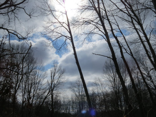
  It doesn't get much better than today, folks! I hiked 14 miles and finished collecting data for Newaygo County on the North Country Trail. The weather was beautiful. It was sunny and the high was 83, but there was a slight breeze that kept it from feeling too hot. And the humidity was low.

There are too many pictures in this post, but what should I leave out?

First of all, lets talk about a little geology. Most of the hills in the Lower Peninsula of Michigan are remnants of a huge glacial moraine that has eroded away in interesting patterns. There is a surviving ridge that runs somewhat N-S throughout Newaygo County. Just east of this ridge, and sometimes cutting through it are holes and channels that have become a series of lakes and wetlands. The NCT threads it's way along that ridge. Today, the southernmost lake in the series that I passed was Nichols Lake. It's also one of the largest. Nichols Lake

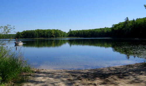
Next one north that you can see from the trail is Leaf Lake. I think it gets its name from the odd shape. Leaf Lake

That lake transitions into a long, long strip of wetlands that follow one of the eroded valleys. If this was Ohio or Pennsylvania, I'd suspect they were old mining pits. But I think these are just natural. wetland

Condon Lake is a long, thin teardrop. You climb a hump in the ridge after a mile-long strip of wetlands, and it suddenly appears. Condon Lake

My hike today only took me a little north from here. But Highbank Lake, that you've seen a few other times, is in this same line. Then the trail veers west and leaves this geologic feature.

One very cool thing I found is one of the very few remaining Manistee Trail markers. That trail pre-dated the North Country Trail. And it looks like the porcupines don't care anything about history. Manistee Trail marker

Best flower finds of the day are Frostweed, Helianthemum canadense,
frostweed


And a Maple-leaf Viburmun, now with the flower fully open. But this picture wins because the sun helped make it a little artsy. I love the shadow on the leaf. maple leaf viburnum

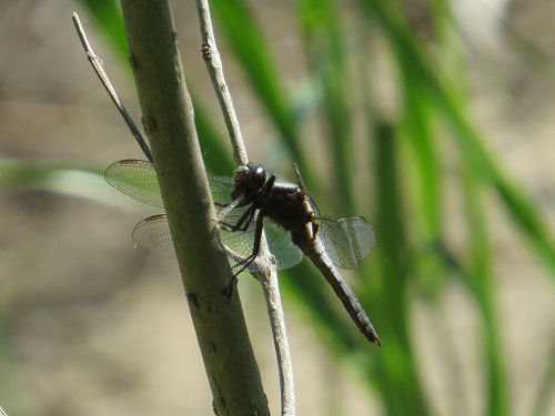
It was a great dragonfly day, especially along Nichols Lake, where I was "wading" through hundreds of zooming and flitting dragonflies. Getting any pictures at all was really hard. But I think most of them were Chalk-fronted Corporels. You can't see the distinguishing marks in this picture, but I did see a lot of them from better angles. I just couldn't get any pictures. There were other kinds as well. Notably some small blue ones, but no certain ID on those. chalk fronted corporal dragonfly

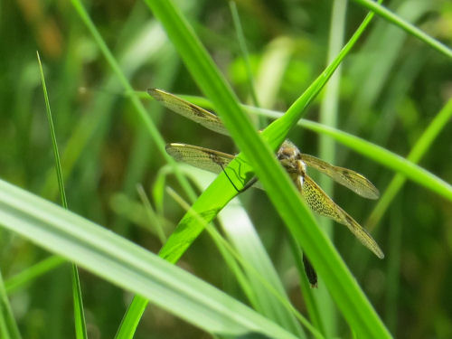
I just was trying to get lucky with a picture of this one perched on the grass. Couldn't tell what it was at all until I got home. I'm pretty sure it's the Calico Pennant, which I learned a couple of years ago. calico pennant dragonfly

And finally, I just like this picture. This was the edge of a wetland that wasn't terribly attractive, but the twisted shrubs and the lighting transformed it into something mysterious. wetland

I met another long-distance hiker on the trail! Liz Jones is hiking from Croton Dam to Munising. Good luck, Liz! It's amazing that I actually encounter hikers multiple times a year, now. This is a relatively new phenomenon for the NCT! hiker

It was also a good day for bullfrogs and mosquitoes and gypsy moths. The only negative for the whole day is that the gypsy caterpillars are hanging on their threads everywhere. I had "silk" threads touching my face all day long. I really could have done without that. But I prefer to emphasize how perfect the day was!

The only other news is that there was a Reading Regatta Zoom event in the evening.

North Country Trail miles for 2021 is at 335.

North Country Trail, Newaygo County, Michigan, FR 5633 almost to Tank Creek and back for a total of 14 miles

See MNF Challenge Hike #5

Saturday, February 13, 2021

Baraga and Berea

  I've been thinking for a long time that I should blog about these two little toys. Today's the day. It was inspired by a hiking friend, Richard Morgan, who framed some of his Buckeye Trail patches with a little green Gumby that he found beside the road on the first day he ever hiked on the Buckeye Trail.

These aren't getting framed (they aren't flat), but they hold their places of honor in my very small collection of stuffed animals. Here are their stories. Baraga is the little plush dog on the left. stuffed dog and rubber duck

Marie and I found him beside the road in Michigan's Upper Peninsula, in Baraga County (Say BEAR-uh-guh), west of Marquette. It was named for the Catholic Bishop, Frederic Baraga. His story is fascinating! He was Slovanian, and came to the United States in 1830. He had grown up during the time of the Napoleanic Wars, which led to instability in his official education. This actually served him well. He spoke German, Slovenian and French by the time he was nine. Latin and Greek were required subjects, so he was a budding linguist at age 16.

Once in the US, he learned the Ottawa language, and ended up at L'Arbre Croche (Cross Village), Michigan. He then moved to Wisconsin to work with the Ojibway, and then founded a mission at L'Anse, just west of Marquette, Michigan. He was known as "The Snowshoe Priest," because he walked hundreds of miles in the winter to serve his mission outposts. He created a dictionary and grammar of the Ojibway language, and fought constantly for the rights of the Native peoples. He was well-enough known that Matthew Brady photographed him some time in the 1850s.

In 2012, he was declared a saint. I've read his journals, and although like most things that were written before 1850, they are tedious, but they were quite interesting. This statue of him, and a small museum are located at L'Anse.
Frederic Baraga statue


The little rubber duck on the right is puzzling. It's definitely a duck. It's definitely wearing a helmet with a visor like some ducky knight, and carrying a sword and shield. Maybe it is some fantasy or game character that I don't know. I'm sure there are many! Anyway, Marie and I found him alongside the road in northeast Ohio. His name is Berea.

We found him on a day that we passed some interpretive signs for Berea sandstone, and a lot, lot, lot of sandstone buildings, foundations, steps, etc.

Berea sandstone was named for the town of Berea, Ohio, where tons of it were historically quarried. It's a fine-grained pinkish-gray sandstone. The sand that formed it actually came from far north, in Canada, and was carried down an ancient river to Ohio. It was laid down about 400 million years ago. I was not there to verify this. I just read Wikipedia.

Anyway, that's the duck's name, and you can follow the link below to see some cliffs of Berea Sandstone. The pictures are from the day we found him.

Perhaps on some other slow news day, you'll see others of my little stuffed animals. They sit on top of my desktop computer, which needs to go away because it is too old, but it still runs one game I like, so I haven't worked too hard at getting rid of it.

In other news: I worked on an editing project and chilled.

See Buckeye Trail Berea Sandstone

Monday, March 23, 2020

Bowman Semi-Primitive Area - Glacial Goodies

 
Today I hiked about 8 miles through one of my favorite local places, the Bowman Semi-Primitive Area. It's within the Manistee National Forest, and includes 3 miles of the North Country Trail. Because it's so special, it's protected from motorized use. You can not even drive to the lake, which keeps it pretty nice.

I did a loop of the NCT and then the Bowman Trails. This is Bowman Lake. It's gorgeous in any season. It's a glacial kettle hole lake- formed when a block of ice calved off the retreating glacier. It has no inlet or outlet, but has remained a lake because it is spring fed.

Bowman Lake

There are several other kettle holes in the area, but they are dry most of the year. The second largest one did have some frozen standing water today. Notice the dark brown vegetation in the bottom. That is leatherleaf- a wetland shrub which indicates that it's wet close to the surface year round.

kettle hole

One of the things I love about this area is that it has just enough topography to be really interesting. It's full of glacial kames. These are little pointy hills deposited by water dripping out the bottom of the glacier. Just like letting wet sand run out of your hand to make a little pointed pile, but on a much larger scale.

kame

It's hard to tell this shot is looking downhill when the previous one was looking up to a hilltop, but the trail here wanders beside and over these rolling humps.

North Country Trail

You might think there would be a lot of glacially deposited rocks, called erratics. There are some, but most aren't very big. This is about the biggest I've seen there.

glacially deposited rock

Here is the other type of geologic feature. This is a bowl-shaped depression, rounded rather than V-shaped as the kettles are. No leatherleaf growing in the bottom. That indicates that it's probably a blow-out, a place where wind picked up the loose sand and just sculpted a bowl.

Bowman Lake blow out

One thing I thought was really interesting because I hadn't noticed it before. With no leaves, you can see for a long way through the trees. That blue ridge in the far distance is the ridge beyond the floodplain of the Pere Marquette River, on the other side.

Pere Marquette River ridge

And a few pretties- some kind of polypore fungus. I liked the yellow and creamy bands.

yellow fungus

It finally got a degree over 40! The sun showed up at the end of the day. Always welcome.

blue sky

And a lovely reflection at the edge of Bowman Lake.

reflection

Hike 100 Challenge for 2020 is at 53 miles.

In other news: I wrote a news article in the morning and did laundry.

56th St to 40th St on the North Country Trail, Lake County, MI, and then return via the Bowman Lake Trail, Leatherleaf Loop and Bowman ski trail. Total about 8 miles total

See A Day on the Trail with Annie

Sunday, August 5, 2018

Other Goodies on the Hike

 
Yesterday's hike also included some other interesting features.

One of the neatest things is that a large interpretive panel has been added to that section by the Forest Service. It seems that the ancient shore of a pre-Great Lakes lake used to be almost that far inland (about 20 miles). It's pretty difficult to take a picture that really shows the landform, but this was the best I could do.

The hill slopes off gently to the west. I took this picture looking east and you can almost see that there is a much steeper drop at the eastern edge of the hill.

stabilized sand dune

Here's how that works. This is a portion of the interpretive panel. The wind moved the dunes eastward and then the sand dropped off the leading edge. They are now covered with forest vegetation. But beneath a very thin layer of soil, there is pure beach sand.

stabilized sand dune interpretive panel

That sandy soil makes several kinds of blueberries really happy. The early ones are gone. Those were probably Vaccinium pennsylvanicum; the plants are under a foot tall. But the slightly taller ones that grow all in the same places were fruiting. Some people call these huckleberries, but an awful lot of blue-fruited things get called huckleberries. At any rate, I think these are Vaccinium vacillans (now V. pallidum). Whatever you want to call them, they taste good!

wild blueberry

Here's a plant I usually show you when it has little red berries instead of little white flowers. These are wintergreen flowers.

wintergreen flowers

What was red this week is the red russula mushrooms. Russula emetica, which is a descriptive name. Don't eat these unless you are a snail or a slug! But they sure are pretty hiding under the wintergreen leaves.

red russula mushroom

I also liked this fungus. Probably just an artist's conch. I didn't want to disturb things to turn it over. I think the bands on the edge are classy.

shelf fungus

In other news: I didn't manage to do much today, sadly. I did write a chapter in DMS Mistletoe, so the day was not a complete waste. And I watched the original Pink Panther (1964) so you don't have to. Although I remembered it as being very funny, it's really slow by today's standards.

See Dead Horse Marsh Walk
if you like this blog, click the +1   or

Like This!


Friday, June 24, 2016

Buckeye Trail- Medina Points 17-23

 
This was hiking day two, June 8. We were still on the Buckeye Trail Medina Map, between points 17 and 23.

About the first half was roadwalk. We always find interesting things to look at even so. I loved this hosta garden. I have six or seven varieties, but not as lush as these, and not filling an entire space. There are so many hostas you really can create a lovely shade garden with them.

hosta garden

Another interesting thing about roads is that there are often historical places to see along the way. Here's one you'd never notice from a car unless you stopped particularly to see it.

I've continued to be amazed at how early northeast Ohio was settled. This was partly due to the Ohio and Erie Canal opening in 1827. There will be lots more about that later. But here's a stone watering trough at Weymouth. The monument says that it was in use from the early 1800s through 1926.

watering trough

The afternoon was spent on trail through Hinckley Reservation. I've shown you a couple of pictures of this place known as The Ledges or Whipp's Ledges, but it's worth a few more. This area is definitely more like southeast Ohio or even Pennsylvania. There are huge outcroppings of the Sharon Conglomerate sandstone which overlies shale. Most of Ohio was glacially scoured and covered with till when the glacier retreated. However, this is one of the places where the original bedrock remains. It's a popular spot for rock climbers, and we hung around for a while watching one guy prepare, but he was still getting ready and we needed to move along. You can see a person in an orange jacket on the top right.

Whipp's Ledges

The sandstone is soft and I love how some areas become honeycombed over time.

honeycombed sandstone

This was my lucky shot, however. There was a tunnel between sections of rock, and the late afternoon light was shining through. What the camera saw is even better than my eye.

rock tunnel

Just for a sense of scale- in addition to immense, we also saw this tiny one taking a hike.

snail

This, however, was the big joke of the day. First the picture, then why it's so funny.

high point

This is trail along a service road as we were leaving Hinckley Reservation. The guide says that at 1290 feet above sea level, this is "perhaps the highest point on the Buckeye Trail." We had a good laugh about this. I'm sure it might indeed be the highest elevation, but it's certainly not much to look at! Good thing we read the words, or we'd never have known it was such a special place.

11.4 miles for the day.

See Buckeye Trail- Medina Points 10-17
if you like this blog, click the +1   or

Like This!