Entries to Win Afghan

Sign up to receive the Books Leaving Footprints Newsletter. Comes out occasionally. No spam. No list swapping. Just email me! jhyshark@gmail.com Previous gifts include a short story, a poem, and coupons. Add your name, and don't miss out!
Showing posts with label Manistee & North Eastern RR. Show all posts

Saturday, July 17, 2021

Kaleva Day

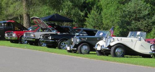
  I'm calling this post Kaleva Day, even though I was there for an event known as Kaleva Days. That's because my pictures mostly aren't about the event, but are an ecclectic assortment of things around town. I participated in the vendor event and did pretty well. Another part of the event was a classic car show. There were lots more cars, this is just a few. antique cars

One man was walking around with a white German Shepherd, which reminded me of Ester's dog, Jade. This one's name was Powder. white German Shepherd

I wanted to swing by the Bottle House. I thought sure I'd blogged about that before, but I guess not. This was completed in 1940 and was made out of 60,000 pop bottles. The man who owned the bottling plant built it, but he died before his family could move in. His name was John Makinen. Kaleva Bottle House Kaleva Bottle House

This totem pole is for my writer friend Diana whose muse is a duck named Drake. The totem symbols come from the Kalevala, an epic Finn tale and the source of the town's name. In the Kalevala legend "the Duck is the Messenger that helped Vainamoinen discover his true powers."
finnish totem pole


There is also a museum in the old rail station. I'll just have to go back! The Manistee and North Eastern RR ran from Manistee to Traverse City, and was one of the many logging boom lines. Link below to other posts that mention it. Manistee and North Eastern engine

I'll just end with a nice planter. It was a good day and there is no other news. urban planter

See Local Finnish Heritage
See Manistee and North Eastern RR

Sunday, April 26, 2020

I Couldn't Stay Inside

 
Today was supposed to be nice, and the rest of the week not so much, so I just had to go out again.

Most of what I hiked is North Country Trail in Wexford County, but then I did a few more miles that connect with what Teeny and I just did a couple days ago.

This is an unnamed creek just east of 12 Road where the trail goes into the Pere Marquette State Forest. I'm not sure if I've seen this exact location before or not. Most of this entire section of trail was re-routed when the wonderful right-of-way along Hodenpyl Dam Pond was made possible by Consumers Energy. I think this is different, and I'm too lazy to get out the maps and really look it up right now.

creek in dappled sun

This is another piece along the Manistee River. Actually, from the time the North Country Trail first crosses the Manistee, at Highbridge, it more or less follows it for about 60 trail miles. Here, the trail undulates between river level and the bluff (which isn't as high above the water as where I was a couple of days ago). There are lots of great views.

Manistee River

If this is not exactly where I hiked with Angie (see chapter "Sneaky Valley" in North Country Cache), it looks very similar with lots of White Cedar growing beside the river.

white cedar

Here is one of many, many oxbows along this old river.

oxbow on Manistee River

I was looking forward to a 60 degree day, and it actually hit 70! Wow. Sun, warmth, my favorite trail. Here is a clump of marsh marigolds.

marsh marigolds

And a nice perky Trout Lily.

trout lily

A Yellow-bellied sapsucker had been busy on this fallen tree.

yellow-bellied sapsucker holes

This walk was 6 miles (out and back), but I really wanted to connect with Eddington Creek from the other direction. I know, I've hiked it a gazillion times, but that is the northernmost piece of trail our chapter maintains, and I've been trying to get condition reports to the president, so I didn't want to leave this piece out. Anyway, this is the old rail bed of the Michigan and Northeastern RR, which we now follow for over a mile.

old rail bed

That added a total of just over 3 more miles, so I ended up walking 9 miles today. North Country Trail total for 2020 is at 177.

In other news: hmmm... I did something else this morning, but I have no idea what at the moment.

North Country Trail, Wexford County, MI, 12 Road to Harvey Bridge and back. Manistee County, MI, Hodenpyl Dam to Eddington Creek and back.

See Teeny's First Overnight- Day 2

Wednesday, June 14, 2017

Fife Lake Loop- Day 3

 
Just 6.6 miles of the loop remained to be hiked. This is the section I'd seen before when it was North Country Trail, but that was in the early winter, so it looked quite different. I did recognize a few spots. On flat terrain, with not too many outstanding points of interest, we moved right along.

Also, it had rained in the early morning hours. We were dry in the tent, but the grass was wet along the trail, and plopping down to rest just made us wetter.

hiker

A little dog knows how to stay dry at rest stops. Just climb on top of a handy pack.

dog sleeping on a backpack

Soon we started paying attention to smaller sights, such as wool sower galls on oak leaves. I'd seen them before, but this one is really large- almost two inches across.

wool sower gall

One nice wet meadow had blue flag in bloom.

blue flag

Let's talk about water. We had found that open water where we camped 0.7 miles south of M 186. There was another wetland with open water about a mile south of that. It was smaller without good access, but you could probably get water there if you were desperate. Can't promise it stays wet all year, though. We had stashed a gallon of water where the trail crosses M 113. It turned out we had plenty still from the morning fill-up where we had camped, so all we had to do was top off our bottles. It seemed a little weird to pour out the rest and crush the milk jug to carry out, but that way we didn't have to go back with the car to get it later. Six miles south of M 186, the trail follows Walton Outlet Creek where you could easily get water again. The day wasn't as hot as Sunday. We started hiking at 69 degrees, and it only barely broke into the 80s before we finished around 3 pm. I think we would have had enough water even without the milk jug stash, but it's always good to be prepared.

Here's Walton Outlet Creek. There is another semi-developed campsite along here which would be a very pretty one to stay at.
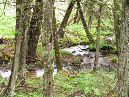
Walton Outlet Creek

We were on a roll. Our feet were soaked, and we could hear a restaurant calling. We stopped twice for snacks and pressed on. We knew we were getting really close to the car when we passed the southern turnoff to rejoin the North Country Trail. (this is looking back)
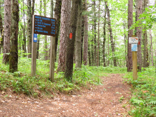
NCT Fife Lake Loop junction

A look downstream reveals the trestle for the Tuscola & Saginaw Bay Railroad (now Great Lakes Central), which is a live track.

Great Lakes Railroad trestle

This brings me to mention a piece of this trail that really should have an interpretive sign. That said, I didn't even think to take a picture when we were walking it. The straight E-W section that's about a mile long, follows the berm of the old Manistee and Northeastern Railroad (Manistee to Traverse City and an associated spider web of spurs). I've mentioned that line before, and another piece of the old bed is part of the NCT near Hodenpyl Dam. This was primarily a logging line, but as the timber began to disappear it carried cherries from Traverse City, salt from Manistee, and potatoes. It was merged into C&O in 1955, and the line was abandoned completely by 1997.

Once again, we were walking along the Manistee River. I just liked this stump.

stump in river

Onward to the car where we had to take a few congratulatory selfies, and then to the North Side Restaurant in Manton for a late lunch. Highly recommended for hikers. The linoleum is peeling and the table tops are delaminating, but we got good, real food and lots of it for very little money.

happy hikers

We had thought our hike was 21 miles, because the text on the map says that. But the very same map (if you add the mileages) only totals 20.1 miles, as does the official NCT web site maps. Well, we probably walked an extra mile to that water pump and looking for not-so-good cache trees. Haha.

Would I go with Sue again? You bet. Time to start plotting another adventure.

If you care, this same piece of trail is part of "The Princess and the P's" chapter in North Country Cache.

Fife Lake Loop Trail, and about a mile of North Country Trail just west of the Old US 131 State Forest Campground near Manton, MI

See Fife Lake Loop- Day 2
See 85.7 and Still Walking for more of the Manistee and Northeastern rail bed
if you like this blog, click the +1   or

Like This!


Monday, October 31, 2016

Hike 100 Challenge- 85.7 and Still Walking

 
Today was a lovely hike, but the mileage was disappointing, only 7.4 according to the maps. Something seems wrong about that. If I hiked 12.8 miles in 4 hours and 10 minutes yesterday, and only 7.4 in 3 hours and 40 minutes today, when my pace felt about the same, either something drastically changed with me or one of those mileages is off. I could have walked farther before turning around, but didn't want to be out more than four hours, so I could be home in time to do some things.

Anyway... I won't be finishing the North Country Trail Hike 100 tomorrow because I'm not going to try to do 14+ miles and get home in time to clean up and go to bell practice. We'll see what the weather is. Now they are saying rain in the morning. I was hoping to hang out laundry. Options not looking so good right now. Maybe I can do a short walk close to home which would leave me with one do-able piece for another day.

I drove an hour each way to do this hike. Long, yes, but I "killed two birds." I had a box of stuff that needed to be delivered to someone, and I got that done, and hiked, seeing trail I hadn't been on for quite a while.

I started at Hodenpyl Dam, the northern end of the section our chapter maintains, and hiked south (and then back) more or less along the Manistee River. To put this in context, here's the view east. The shiny spot in the lower middle is the Manistee River below the dam. The big flat plain area across the middle of the picture is the dam. The bright line above that is Hodenpyl Dam Pond. The trail continues east and north from there. Most recently I hiked that with Dan and Ruth Dorrough. See Two Awesome Days.

Hodenpyl Dam Pond

Just below this is the Little Mac, the second largest suspension bridge in Michigan, which spans the river. It's not actually on the North Country Trail, but is on the connector with the Manistee River Trail. I didn't cross it today.

Little Mac Bridge

I'm not sure I'd actually ever done all of the first mile of trail I was on today. This section was completely re-routed since my hike that counted for my NCT E2E, and I think perhaps I hadn't seen this piece. It's on the rail bed of the former Manistee and North Eastern RR.

Manistee and NE RR bed

As soon as you leave the rail bed, the trail drops to Eddington Creek and Eddington Bridge, a lovely spot, and one of the first hikes I ever took on the NCT.

Eddington Bridge

Eddington Creek

Then begins a long climb along the side of a valley, until you reach the bluffs above the Manistee River.

benched trail

I pulled this view in with the telephoto to try to capture the colors on the far bank of the Manistee, and the blue hazy hill top beyond. It looks much farther away when you are there. On the far side is the Manistee River Trail which forms a 20 mile loop with the NCT. This is one of the most popular weekend hikes in the state, which is why I went on a Monday, not the weekend. I didn't see a single person. Yay!

Manistee River

This section of trail is characterized by several long gentle climbs and descents. Even with these hills, I can't account for my apparent lack of speed. The trail yesterday was rolling hilly, so I was going up and down all the time, just not for such long stretches.

Here are some fun finds. A really large red oak leaf.

red oak leaf

The sun came out toward the end of my walk. That always perks up the fall colors.

fall colors

I end with a question. Did you ever wonder why so many aspen leaves keep one streak of green in the next to the lowest space between veins? I see this all the time. I made a whole collection of them. I have no guesses as to why this happens.
EDIT: I did find out why this happens. See why at Yellow Memories
streaked aspen leaves

Total miles on the Hike 100 Challenge 85.7, with 14.3 to go. Chance of finishing tomorrow- zero. I'm just not going to push that hard. But today was a great hike!


See Marilla to Suspension Bridge
if you like this blog, click the +1   or

Like This!


Wednesday, March 19, 2014

Curious by the Manistee

 
I've been curious every time I've driven over the bridge where the Manistee River flows into Manistee Lake. There is what appears to be an old railroad grade, leading off into the marshy area at the head of the lake.

Wildlife management area

Yesterday I stopped long enough to be able to read the sign.

Wildlife management area

It certainly looks like foot travel is not restricted, so one of these days I may just have to see how far in toward the lake that goes. The berm continues north along the river, on the other side of the road too. My RR atlas says that was the former Manistee and North Eastern line that ran as far as Northport in the Leelanau Peninsula. Fifteen miles at the far north end are now a non-motorized trail. Of course, I wonder how far one could follow it, starting here at its southern end.

Looking south, toward the lake, the river begins to break into braided passages. You can see part of the older section of Manistee, with a church steeple, across the way.

Manistee Lake

See Everything is Better with Sunshine for another angle of Manistee Lake
if you like this blog, click the +1   or

Like This!