Entries to Win Afghan

Sign up to receive the Books Leaving Footprints Newsletter. Comes out occasionally. No spam. No list swapping. Just email me! jhyshark@gmail.com Previous gifts include a short story, a poem, and coupons. Add your name, and don't miss out!
Showing posts with label mapping. Show all posts

Friday, July 11, 2025

Turning Tracks into Maps

 Today, Bill and I spent all day with Matt Rowbotham, starting to get the data we collected turned into trail. Matt set up a big screen in his garage, so we could all see what was going on. For a lot of the day, Will Brazill, the new NY-VT Regional Trail Coordinator also participated by Zoom.
people with computers and a large screen in a garage


Matt took all our tracks from the three sources: Avenza, OnX, and an Apple Watch and imported them into the software that NCTA uses to generate the Avenza maps. This shows about 0.2 mile of trail. The orange line is the Avenza track that Bill took. The line of fat purple dots is from Bill's Apple watch. The thin purple line in between is what I took with OnX. Now... the current line on the NCT Avenza maps is the red dotted line way off to the right. This is the kind of thing our data is going to be able to correct. The light green dashed line is where Matt chose to average the data from our three tracks. (I'm not sure what the darker green dashed line is.) Note that speech to text put in "punching" for "puncheon." But we know what it means.
gis tracks


Here's an example where our three tracks were in close proximity. And yet, the spacing between the two outside lines is about 20 feet. This happens because of many possible reasons. The apps need to communicate with four satellites to collet a point. The different apps may not choose the same four satellites. The apps may collect a point after a certain time interval, or after a certain distance which can affect accuracty. And, although civilians are allowed to have access to quite accurate data now, these low cost apps don't have the capability to get super accurate. Thus, the value of having multiple tracks. You can see where Matt is placing the "official" line (light green). He's pretty much going up the middle, but if two tracks are close together he gives them more weight.
gis tracks


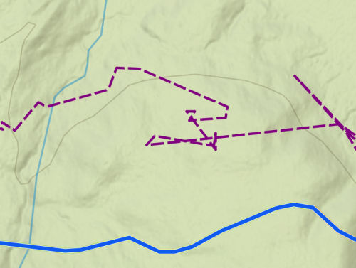
Here's another reason to have three tracks. Every once in a while one of our devices would seem to go haywire. This shows my purple track way off the trail and acting berserk (I was not over there wandering around). Each device took a turn or two doing this. We really don't know why. But it still left two tracks to average.
gis tracks


We got 87 miles of trail in the NCTA software today. That is a huge number for a single day. Matt still has some additional work to do, but he's hopeful these miles will be in the fall update.

The structure inventory data got sorted a little better, and we have a plan for what to do with it next.

Long day. 3 hours driving, 8.5 hours sitting at the picnic table. So very worth it, but I'm going to go get off my butt now.

See What We Did in the Adirondacks

Tuesday, July 1, 2025

What We Did in the Adirondacks


Today I finished adding numbers to all the inventory items from the Adirondacks. I came out at 272 entries, but that's not 100% accurate. I may have recorded items that the NCTA doesn't need, and they may want to count some that I didn't number. For example, is a rocky ford of a stream that never had a bridge a "missing bridge," or is it "nothing?" Or... all the really muddy places that never had puncheon don't really count in an inventory. Does a board someone stole from another place and threw down in the mud count as puncheon or not?

Anyway, we recorded a lot. That is an average of 27 items a day. I went into this thinking it would be more like 15 per day. That was my pre-trip estimate. Only about half of what was out there!

We were recording GPS tracks of the trail on 3 different apps: Avenza, OnX Backcountry, and an Apple watch. Then we added a waypoint for every item, and some things that weren't "items" like fords or mud. Here's what that looks like in OnX Backcountry. The light blue dashed line is the track we took up the east side of Jones Hill.

The green balloons are the waypoints. I marked them in OnX, Bill took a photo with NavCam on his phone which embeds the location and time in the picture. Bill recorded info about the item and condition in Avenza, and I filled out a paper sheet with that info as well, in case the digital data went belly-up. I also took pictures with my camera. Hopefully, between the two of us we got pictures and info about almost everything. Occasionally I forgot to take a picture. I lost two pieces of track. Bill lost one. We tried to come back with duplicate data for everything.
OnX track


We did manage to streamline the process a bit, but nevertheless, the whole thing was tedious. It was a joyous thing to me at the same time, because we were collecting data that NO ONE had previously compiled. Next week we are meeting with Matt Rowbotham, NCTA GIS specialist, to get it all in a format that is consistent with the current maps and inventory data. Having 3 tracks means that the line that ends up on the map will be more accurate. There are always inconsistencies between tracks on various apps.

A group called GPS Rangers will take our tracks and go through again adding to info we may have missed and taking yet another track. They can verify our inventory and improve photos that don't capture just what the NCTA needs to know.

In general, I would like to say that Adirondack trails are generally in much worse condition than the NCT standards. This is true for a combination of reasons. The attitude toward backcountry trails in the northeast tends to be more toward embracing the suck because it is more "real." They also don't have enough volunteers to maintain them. That is going to continue to be true of the NCT there, similar to the way it is on the Border Route section in Minnesota. There aren't very many people who live close by to go out and work easily.

Bridges ranged from non-existent or broken to brand new. I shared some of the broken ones, and the missing one that we declined to ford. Here is a brand new one with beautiful rockwork approaches. Occasionally infrastructure does get fixed. Supposedly the missing bridge is going to be rebuilt next year. But no one knows when the broken one we skootched across will be repaired.
bridge east branch trout brook Adirondacks


We took numerous pictures of signs. The familiar brown and gold Adirondack signs are plentiful, and usually in the right places, although mileages are notoriously off. Some are in great shape, some are not.

This is typical, and also in average condition with the trail marker disc missing on the top sign. Trails have red, yellow, or blue discs which may or may not be present in sufficient quantity to actually follow the trail.
Adirondack trail sign


I was thrilled to find at least minimal NCT signage on most of the off-road sections of trail (which was all we inventoried). Here is one of the junctions with the Northville-Lake Placid Trail. The NPT goes N-S and the NCT E-W. They cross and are concurrent for a short way near West Canada Lake
NCT NPT trail junction


Just yesterday, on an Adirondack Trails Facebook page, someone posted a picture of one of the NCT emblems and a blue blaze. They were asking what new trail this was- what those markers meant. This is awesome. New hikers getting acquainted with the North Country Trail.

And the mud. To be honest, we did not see any real solutions to Adirondack mud. It is essentially peat, and it can be 18 inches or more deep at certain times of year. It holds water like a sponge, and once a trail section gets churned up it never really drains. Serious water diversion tactics can be deployed, but then they wash out in heavy rains. We inventoried more damaged culverts than functional ones. Here is an example of serious puncheon that at least stayed in place. These are squared logs about 12" x 14". But someone had to drag those babies in there. That is labor intensive.
log puncheon


I know that when they rebuilt the Sacandaga River Bridge in 2022 the pieces were dragged in on sledges by horses. A lot of work. Many of these locations are far from any kind of road access.

The Adirondackers are in love with their lean-tos, as is almost every trail person. The typical three-sided shelter is, after all, called an Adirondack shelter. I think these are maintained and rebuilt preferentially over actual trail.
Adirondack shelter


The Adirondacks has had a special place in my heart forever. I think I was seven the first time I was inside the "blue line," but my first serious hiking there was in 1966 with my friend Paul.

I've been thrilled to help build NCT trail in a couple of places there in 2020 and 2021, and now to be able to participate in this mapping and inventory project really brings me a ton of satisfaction. We still have the data work to do with Matt, but a date for that is scheduled. There will soon be accurate NCT maps for the Adirondacks!

I mostly did computer work again today. Back to some editing. Did laundry and managed a few minutes in the flower beds. One step at a time!

See Low to High

Wednesday, April 17, 2024

Sneak Peek - How to Hike the North Country Trail

 This project is all Matt Rowbotham's fault! I'm only half kidding. He approached me at the Celebration in October of 2022 and suggested this would be a worthy and easy project. He was half right.
cover of How to Hike the North Country Trail


The first part of the book is about 30K words of text that explain why the NCT is different from other long trails, both in experiences and management. This is more or less done. I've sent it to some fact checkers and have to go back through and incorporate their feedback.

The second half is going to be a listing of all the known legal places to stay overnight along the trail. This is the daunting task. It has taken a while to get a format that is understandable, and works with all the odd configurations we have to deal with. Huge thanks to Marianne Duvendack and Cathy Laman for helping me get that whipped into shape.

Here is a sampler pdf with the opening to the campsite half, including the legends. Then it skips to a list from western Wisconsin.

Link to a Sample pdf of How to Hike the North Country Trail

I did my editing quota and then worked like a fiend on this book. I have to keep my nose to the grindstone or I'll never get it done in time. But I'm also supposed to be doing other things... I have campsites listed for about 1200 miles (that's about a quarter of the trail), and not all of those are formatted correctly yet.

Also, my car has new brakes. Driving is an expensive hobby.

See More Mapping Fun

Friday, October 20, 2023

More Mapping Fun


Today, I went to Traverse City and spent all day working with Matt Rowbotham of the North Country Trail Association. His title is GIS Program Manager. GIS=Global Information System. That means he does all the map data processing for the 4800 miles of trail. (And creating specialty maps. And being the IT guy.)

If you can see the lines and lines of text below the green map section, that is the database where all the information is stored that you see when you click on a trail segment in the interactive map.

You may remember that from time to time I've talked about collecting map data for the Adirondacks. Here's Matt, taking parts of what I've noted and tracked and adding them to the full map database.
man at computer with mapping software


Here's what a few miles of data look like on my phone in the Avenza map as I record it. This was a place where no one could figure out where the trail was supposed to be. It's where Marie and I went back and hiked from the other direction just before the Celebration. Now, it's close to being ready to put on the interactive map on the NCTA web site.

If anyone wonders why it takes so long to get these maps right... the choice of trail route had to be made. Since no one had previously collected GPS data for this, the first line drawn on the map was an approximation, sometimes using a basemap that shows the same trail. But that map was probably made before there was GPS. So now there are two wrong lines. If I (or anyone) collects a track of the actual trail on the ground, that gives Matt better data. But there is still error in those lines. So it's better if there are two or more tracks to create a new trail line. But even one current one is better than the non-GPS guesses. Then Matt has to get all the info in the database about important things- who owns that property, the name of the segment, water sources, permitted use, camping options, hazards, etc. It all takes time. 4800 miles is 25,344,000 feet. And we're trying to get every one of them mapped correctly.
screen of Avenza map


It rained all day, but that made the leaf colors look bright. I took a few pictures on the way home.


Here's a picture of Hodenpyl Dam Pond from the rest area overlook on Rt 37.
Hodenpyl Dam Pond with fall colors


This took all day. I didn't sleep much last night, so I'm probably about done for the day. But this was really exciting to me-- to be a serious part of the effort to make the trail discoverable in the Adirondacks.

See Map Fun