The farther south we hiked, the easier the walking. Overall, the day was to be downhill, and an easy one. We had lots of time to joke about things like the trail building technique used there to stabilize trail by taking it around a tree on the uphill side. So, maybe we didn't climb 900 vertical feet, but we might have stepped two feet up to get around 450 trees.

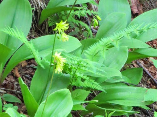
We always see lots of Clintonia on our May/June northern hikes, but I never get tired of the cheerful yellow flowers.
As for the hiking itself, my stamina was improving and we walked 40-45 minutes between rest stops, easily. One requirement when backpacking is to avail oneself of clean drinking water. Although we'd used a Steripen for the last couple of years of backpacking, we went back to the filter for this trip. The Steripen needed new, expensive batteries, and we like the filter just fine.


The trail followed a ridge for a while, with views of Blue Ridge Mountain. Not to be confused with the Blue Ridge Mountains, farther south.

We crossed a snowmobile trail and a creek, and ascended beside this impressive rock. There was just a funny jog east and then back west, mostly downhill from the looks of the topo map, until we would reach Rolston Rest Shelter. Again, we were going to go past the shelter and find a campsite, but it was more or less our goal.

Well, we kept hiking uphill, way to the east, for over half an hour. The trail made the jog back to the west. Now we'd go down to the shelter. Wrong. We kept climbing uphill. The elevation profile was clearly wrong. I kept looking at the topo map, wondering if I'd read it wrong (very fine detail), but the red line sure appeared downhill to me. We climbed that interminable downhill line for another 35 minutes. I was doggoned if I was going to rest before we reached the shelter. Finally, there was a short downhill, a private road crossing, and there we were, at the shelter in time for lunch. OK, a late lunch.

We stayed there for a couple of hours. We'd met quite a few hikers in the past few days, all northbound, but they'd all been using the shelters for sleeping. Another reason I'm not crazy about shelters... I'm not that social. But we love to rest in them mid-day. We read and signed the log book- always fun. We played our game in comfort, leaning against the walls. About four o'clock we wandered on down the trail for another 25 minutes, and found a decent tent site. We got set up and zipped in just before the rain began. We didn't even get sprinkled on!
Miles for the day- a relatively easy 8.5 (except that weird uphill made it seem longer- I've studied the map more closely at home, and where the trail line is drawn is downhill. I can verify that unless both of us had up-down sensory malfunctions at the same time, something is goofy!)
Just one more day. I'm always excited and sad at the same time about that point in time.

 | See Long Trail- Day 2 |
| if you like this blog, click the +1
| |
5 comments:
that view is amazing. Glad to hear you got zipped in for the night before the rain started
Great view of the reservoir. The map shows you traversed some very interesting topography.
I'd be leery of who I'd meet in those shelters. I think I'd sleep in my tent instead.
Looks like a very beautiful place. I could go down hill all day, but the uphill part would get me every time.
Lovely trail and thank you for sharing your beautiful hikes with us!
Post a Comment