Entries to Win Afghan

Sign up to receive the Books Leaving Footprints Newsletter. Comes out occasionally. No spam. No list swapping. Just email me! jhyshark@gmail.com Previous gifts include a short story, a poem, and coupons. Add your name, and don't miss out!
Showing posts with label Superior Hiking Trail. Show all posts

Wednesday, March 8, 2017

The Rest of the Story- Finishing Minnesota

 
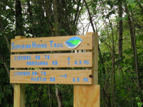
After our night at the Voyageur Motel, August 17, 2009, we hopped back on my final piece of North Country Trail to finish in Minnesota. This was also part of the Superior Hiking Trail. Over the next six days we hiked an additional 69.2 hilly miles. (For those who may know the SHT- from Finland to Gooseberry Falls.)

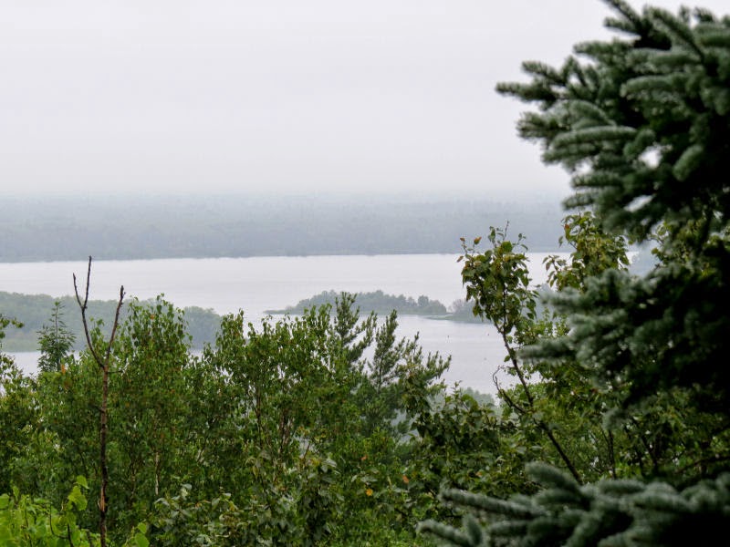
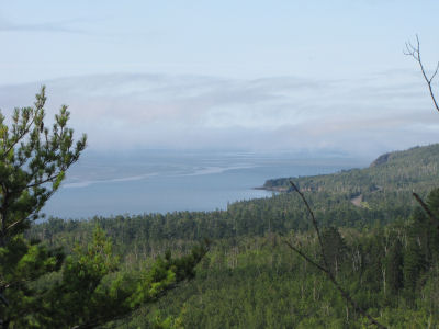
This is what a lot of that trail looks like. It's truly gorgeous. Although it was hilly, our daily mileages were shorter and we felt pretty relaxed about the whole thing.

Except one part. This was the wettest we'd ever been on a hike. It rained, really rained, for three days straight. Everything we had finally got totally soaked. That's not necessarily fun. The third night, I was determined to start a fire, and I did manage. But I have to say that even for me, it was a challenge.

Superior Hiking Trail

I posted quite a few pictures from this hike in other blog entries. I'll list them if you want to revisit any.

• See Closer In and Farther Out for an overview of the scenery
• See Berries! for some colorful botany
• See Makin' Tracks for probable wolf tracks
• See More Tracks for possible cougar tracks
• See The Coffee Clatch...er... Qoffee Quack, Part 1 a funny duck story begun
• See The Coffee Clatch...er... Qoffee Quack, Part 2 a funny duck story finished
• See North Shore Water Features for rivers and waterfalls

This cedar root is one of my favorite shots from that hike.

cedar root

We had hiked over 250 miles since leaving home, our longest trip ever.

Marie's leg gave her no problems on this piece. Mine was fine for the first four days, then began to hurt again. Although I never had it x-rayed, the diagnosis was "probably a stress fracture." It continued to hurt through September, and I spent serious time sitting around with it elevated, and iced, popping ibuprofen, because I had plans to hike in Ohio in October.

Of course, I did just that. Leg was all better in time, and has never had this problem again even when I did the long mileage pavement days in Ohio this past year.

It's been fun for me to review this trail time. Tomorrow I'll be back to local, normal stuff.

if you like this blog, click the +1   or

Like This!


Monday, August 25, 2014

Hiking and Home Again

 
Didn't get a chance to post last night. When we finished activities I would have had to use WiFi through the phone, and a thunderstorm was starting, and I wanted to get in my tent before I got wet.

Yesterday, I got to stay an extra day after the non-conference and hike again with Dan and Ruth Dorrough. I had hiked with them for a day when they were here in the Manistee National Forest. This picture was taken in this morning's sun, after the storm.

Dan & Ruth Dorrough

We met for the first time over 10 years ago, but have only really gotten acquainted more closely in the last couple of months. We agree that it's like we've been friends forever. I wish I could just disappear from real life and hike on with them as they continue their section hike of the North Country Trail. Yesterday, we were on the Superior Hiking Trail piece of the NCT from Martin Road to Lismore Road. Only 7 miles, but it was enough because we had to all get re-organized from the days at the villa. It takes a while to get all the gear re-shuffled to a different lifestyle. And they will be continuing on with their hike, so they had a lot of organizing to do.

SHT sign

The day was damp and drizzly, but not bad. This mushroom was doubling as a little bathtub for someone.

mushroom

Most of our walk was in nice woods, but there were occasional openings with beaver ponds or former ponds that are now meadows.

beaver meadow

Sometimes on a damp day all the colors just seem to pop out. These little beauties wanted to show off.

red mushrooms

We finished in good time, and did some necessary shopping and eating, then returned to our campsite. Dan and Ruth will be doing more backpacking than they usually do in the Minnesota Arrowhead, so we went through their packs, because they wanted to hear my suggestions. Pretty much as soon as we finished that a fairly amazing thunderstorm rolled in, and we all scooted for our "bedrooms."

Mine was still dry and snug this morning (on the inside, but that's where it counts).

Big Agnes Fly creek tent

Sadly, I did have to leave this morning. About 3/4 of the way home I crossed the Big Mac.

Mackinac Bridge

And arrived home in time for sunset through my pines.

sunset

Wonderful trip. I'd like to keep hiking forever.

See North Country Trail Section Hikers Over 2600 Miles
if you like this blog, click the +1   or

Like This!

Friday, August 22, 2014

Hike and Awards

 
Today, I went on a 6 mile hike on a piece of trail that is North Country Trail and Superior Hiking Trail, above Duluth. This is a new piece since my time of hiking through this area. I always like to see places that the trail has been re-routed to something better.

We began in the fog and climbed from 123rd Street to the top of Ely's Peak. There are great views from up there, but we didn't see them today! This is all basalt bedrock where the stone outcrops.

ely's peak

The fog changed the feeling of the hike. And I roughly knew where I was, but it wasn't nailed down in my head in relation to other places I'd been there. And then, we came out on a road, needing to cross Stewart Creek on a bridge, and! And! It was one of the most memorable structures of that hike I'd taken in 2000. Beautiful stonework.

Stewart Creek Bridge

Back into the woods and we came across a lovely mushroom (some kind of bolete) that was longing to send a message to my friend Rainfield. Perhaps he will translate for us.

bolete

By the time we were nearing the end we began to be able to see a little bit down into the St. Louis River. These hills that encircle Duluth, and across the river, Superior, Wisconsin, are the former shores of glacial Lake Duluth.

St. Louis River

In the afternoon, I went to presentations on the Kekakabic and Border Route sections of the NCT. And after dinner was the annual awards program. It's always neat to see how many people receive recognition for hours of volunteer time, and then the special awards for outstanding service in various categories.

Some additional visiting and discussing of trail issues with friends afterwards. Another wonderful day.


if you like this blog, click the +1   or

Like This!

Wednesday, September 9, 2009

North Shore Water Features


Twin Falls Baptism River Minnesota

Nearly 48 hours of rain made us and all our gear wet and somewhat less than cheerful, but it made the rivers of the North Shore of Lake Superior spectacular. It was hard to choose only a few pictures to show you, but these are the ones I selected. The one above is the Twin Falls on the Baptism River. Very scenic, but the Baptism River kept the trail at arm's length.

Foam Pill, Split Rock River Minnesota

The next day we reached the Split Rock River. It was my favorite. There were cliffs, and rock formations, whitewater, and flat water. We ate our lunch on a rock projecting into the river. But I chose to show you this foam "pill" that the currents had formed in an eddy. It was about two feet across! The picture below is the opposite shore from where we ate lunch. I like the blocky cliffs and the vertical trees. Just outside the picture the water was white and roiling. Recall that the story about the merganser ducks riding the rapids was on the Split Rock River.

cliffs, Split Rock River Minnesota

A couple of days later we reached the Gooseberry River. It can be just as wild as the first two, but it had now been several days since the rain, so it was calmer again. On this day it was a river with places one could play and explore. This boy was enjoying the day with his family, and who can resist rocks and water on a warm day?

Gooseberry River Minnesota

Gooseberry River Minnesota

I think tomorrow I'll share some fun closeup details from the hike. Then maybe it will be time to bring the posts back closer to home!

See The Coffee Clatch, er... Qoffee Quack, Part 1
if you like this blog, click the +1   or

Like This!


Tuesday, September 1, 2009

Closer In and Farther Out

 
Leskinen Creek Camp

I have been home for almost a week, and I'm trying to get my head around real life again. Today I'll just share some of the biggest impressions of the section we backpacked.

The Superior Hiking Trail is one of superlatives. It is named for its close association with the shore of Lake Superior. It was great to be back in the woods, with our small tent nestled between the trees rather than in a large public campground. Even in the busy summer season we only had to share a campsite with anyone on two of our six nights on the trail.

a valley view on the Superior Hiking Trail

The SHT makes a "point" of climbing to nearly every rocky vantage point that can be found. Even though we were generally walking southwest, unless we studied the topo map or read the guide it was always a surprise whether we would have a view of valleys, distant rivers, lakes and hills, or whether we would be looking at Lake Superior. This depended on which side of the hill we had climbed, of course. Sometimes we looked it up beforehand, and sometimes we just let ourselves be surprised.

Lake Superior from the Superior Hiking Trail

This last one was a lot of fun. We knew that we were supposed to climb Sawmill Dome this day, and in the morning we thought that this round hump must be the "dome." Sure enough, a couple of hours later we were standing on top of this round hump with its rocky sides!

Sawmill Dome on the Superior Hiking Trail

So I've now got 3947 miles of the NCT done! With 104 miles coming up in Ohio at the end of September I should be over 4000 before the end of the year. However, I came home with at least tendinitis, and maybe even a stress fracture in my left leg. So.... I'm doing a lot of resting, icing, and ibuprofen. I hate taking meds, but I HAVE to have this leg ready to hike and bike in four weeks. When I got home I couldn't even do two revolutions of the pedals on the exercise bike. Today I did two minutes without severe pain. I really hate being good, but I MUST so that I can make my goal.

Tomorrow I'll show you some more Minnesota trail treasures!


See About the Superior Hiking Trail
if you like this blog, click the +1   or

Like This!


Saturday, May 30, 2009

Early Yellow Minnesota Flowers

 
It was too early for many flowers to be out yet, but several were opening during the final week of our hike. I'm sharing these two because they are ones I had not seen before.

yellow corydalis in Minnesota

Above is Yellow Corydalis (Corydalis flavula). It is related to bleeding heart. I've seen Pink Corydalis on several hikes, but hadn't previously seen the yellow ones except in pictures. The pink ones are more delicate- almost so pale that they often are hard to see against the granite on which they like to grow. The yellow ones seem much more showy even though the plant is only a few inches high and each bloom about 1/2 inch long. We found them growing at the base of some rocks in the area that had been logged (see yesterday's post).

fly honeysuckle in Minnesota

The second one is American Fly Honeysuckle (Lonicera canadensis). This is one of the native honeysuckles, much more welcome than the alien Tartarian Honeysuckle bushes that grow everywhere in Michigan. The flowers were very pale yellow, maybe that's not quite so obvious in the picture. Each trumpet is about one inch long, but the bushes were several feet tall. Somehow I had thought that the Fly Honeysuckle had a sweet scent, but they didn't smell like anything at all. Honeysuckle is easy to identify, at least in general because it is one of the few shrubs with opposite branching. Also the flowers and berries are in pairs, often looking like two berries stuck together.

Wow, tomorrow is the last day of May. It needs to be contest day! I'll try to make one that isn't so daunting. Hope some of you will play!

See The Moles Missed This One
if you like this blog, click the +1   or

Like This!


Friday, May 29, 2009

Walking Into Spring


photo label

This is the first time I've taken this long of a trip in May. I've been out for five days in this month other years. But never before have I so completely walked from bare trees and the end of winter into green leaves and wildflowers.

The top picture was taken on our second hiking day. The view is of Lake Superior from the Superior Hiking Trail. As you can see it was a gray day and the trees are all bare and gray except for the conifers.

photo label

The second picture was on the last hiking day. We had just emerged from the greening trees in back of us into an area that had experienced a severe blowdown. Timber was salvaged, leaving the space looking about the same as if it had been logged (and difficult to walk through).

This afternoon I took a slow walk around my trail at home and picked some of the wild asparagus here. I thought that I might miss it all, so I was very happy to find some yet. It was rather mature, but I cut it up and made it into soup for dinner. I forgot to take a picture! Obviously I'm not back into blogging mode just yet-- trying to get my head around the schedule I was keeping before the hike.

I think tomorrow I'll show you some wildflowers from the hike.

Thursday, May 28, 2009

Home- The Hike Was Great!


hikers by Kekekabic Trail sign

We don't look like the brightest bulbs in the room in this picture, but here is the group (except me, I took the picture) that finished on the 24th at the Kekekabic Trailhead near Ely, Minnesota. We had a fifth hiker join us for the final five days. The weather warmed and the end of the hike was pleasant, for which we were not sorry!

Dinner at the Chocolate Moose in Ely was as wonderful gastronomically as the hike was wonderful hikin'omically!

We stayed in small motels/cabins on the way home with no web access. Marie and I arrived at my house last night, and spent today cleaning gear and putting it away before she left at 4 pm. It just all seems to have happened too quickly!

I've got so many things to catch up on!

spruce grouse

Here's one fun thing to share. This spruce grouse gave us a nice display on the next to the last day of the hike. After watching us for several minutes it flew to roost in a tree right over the trail where I guess it thought it was hidden. We hiked right under it! They are odd birds in that they are known for letting people get very close to them.

See Trail Work Day
if you like this blog, click the +1   or

Like This!


Sunday, May 24, 2009

Did We Make It?

 
campers sitting by a lake

Well, if all went as planned we have reached our car this afternoon, and are probably warm and snug in a motel.

There aren't too many hikes I've led with as many unknowns as this one. As late as the day before we left home, I was getting conflicting reports of "2-3 feet of snow still on the trail" and "mostly bare ground with a few snow patches." We had read of Nimblewill Nomad's terrible experience just a couple of weeks before we began our hike. We know the trail is difficult to follow (marking is not allowed in the wilderness which makes it even more difficult). I'm sure we've had an adventure!

But I hope that you've enjoyed the tour while I was in the woods, and perhaps learned a little more about trails. I also hope that I can do a live post tomorrow, so I haven't scheduled one. You'll know in another day!

I'm sure we've enjoyed some evenings similar to the one pictured above from 2003.

As I write this, we need to pull out of the driveway in 4 hours and 45 minutes. I still have an hour of work to do, and then I will catch a couple of hours of sleep. I tucked Marie in long ago, so she will be fresh to drive. She is a morning person, and I'm the night owl. Hubby just got up (3 am) to do the paper route, and I need to sign off. See you soon, I hope.

See The Blog Plan for the Arrowhead Hike
if you like this blog, click the +1   or

Like This!


Saturday, May 23, 2009

Volunteers


photo label

So, how does the trail stay open at all, given wind, fire, water... The answer is "VOLUNTEERS."

Almost all of the work of any kind (trail building and maintenance, through making phone calls, landowner negotiations, leading hikes, etc) is done by volunteers. Why? They simply love to be able to be part of creating inviting places in the forests, hills, prairies... to walk. More often than not, they are hikers who woke up one day and realized that they wanted to give something back to the trails that gave them so much peace.

Next time you take a hike, think about who it is that makes that pathway safe and clear for your enjoyment. In a park, it may be your tax dollars. But on many trails, it is volunteers.

See The Blog Plan for the Arrowhead Hike

Monday, May 11, 2009

End of the Superior Trail


Today / tomorrow we are making the switch from a rather new trail, the Superior Hiking Trail, to one of the oldest long trails in the U.S, the Border Route Trail.

photo label

We are camping here where the two trails meet, separated by just a few yards of road walking and the Swamp River. There is road access here which is why I have advance pictures. Lyle and I drove here in 2003 to check out possible places for supply boxes. We found a couple of established campsites with picnic tables, so we may be camping in relative luxury tonight. If it's still there the guidebook says there is even a latrine!

See The Blog Plan for the Arrowhead Hike

Sunday, May 10, 2009

First Crossing of Arrowhead Trail


northern view with spruce and water

The section today I have very little advance information about. We are hiking from Hazel Lake to Woodland Caribou campsite. At least it begins with some downhill! If you look at yesterday's elevation map we begin by heading down to the dip at the middle. Then we climb again. In fact we climb to Rosebush Ridge the highest point on the SHT, although the guidebook says there is no view. Don't worry, the SHT has LOTS of great views from other locations. The picture above is not from this section, but it shows the kind of terrain we will be in for much of this entire hike.

The second day of hiking can feel bad, although we've decided that the third day is the worst. One winter I did a series of 3-day weekend hikes to walk across southern Michigan. At the end of them all I thought maybe I was losing my interest in hiking. Then I realized that I had set myself up to finish each one on the day that feels the worst. That was not a great plan!

I am also hopeful that there will be some greening up occurring. I'm thinking as I write this on April 30, that in another 10 days it might look here, like it does at my house, which is reasonably green with trees flowering. May in Minnesota can be goofy with freezing nights and 80 degree days sometimes.

I think I've written enough about nothing for today!

See The Blog Plan for the Arrowhead Hike

Saturday, May 9, 2009

Heading UP the Trail


northern section SHT elevation map

Today we start hiking for real! Here is the elevation profile for the first three days of our hike. Of course it's "squished," so the climbing won't be nearly as bad as it looks, but we'll be going pretty steadily uphill all day today. The very first part follows the Brule River with a special place to watch for named Devil's Kettle Falls.

mushrooms under yellow leavesThis was the first picture (other than a signpost) that I took in 2000 when Marie and I started here and hiked south. That was in September. This is May! We don't know how much snow we will encounter. Just 2 weeks ago Nimblewill Nomad reported hiking through snow, sometimes as much as 2 feet deep at what will be the western end of this hike for us. I sure hope that a lot more of it has melted by now.

Today four of us are hiking north. If everything has gone as planned we have supply boxes and cars placed at all the right locations, have our wilderness permit and are really on our way! I'm hopeful that this will be more enjoyable, and less of a trial than Nimblewill Nomad reported.

See The Blog Plan for the Arrowhead Hike