So, you know I'm trying to get ready for this hike I hope to take in May. I plan to really challenge myself on it, and in order to be ready to do that I have to be seriously in shape. This was the test. Today I hoped to hike 14 miles with the 25 pounds in Teeny. I did it! 14.5 miles. I can still walk although there are parts that don't feel so good. (But nothing deadly awful) We'll see if I can move tomorrow.
The hike was defined by the Manistee River. I began at Chicago Avenue. I like how the trail just slips down off the road. People don't even know it's there.

The first bit of water you see below is a backwater of the Manistee, known as Blacksmith Bayou. There is a National Forest Campground there, and the trail crosses the road that leads down to it.
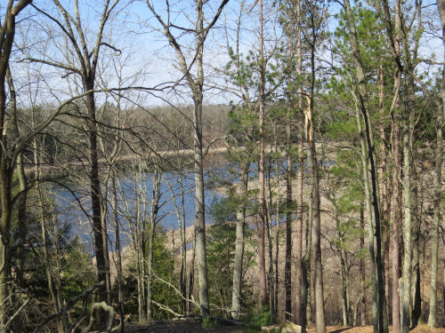
You pop out onto Highbridge Road to cross the Manistee River. I wonder how many pictures I have of this exact same spot, looking downstream from the road bridge. It's never the same, and I always seem to stop and snap a photo.

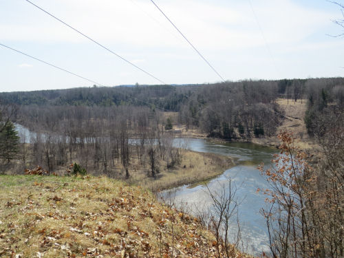
There's a little roadwalk, and then you head into the woods on the north side of the river. Here's the scenic view from near where we did the archaeology sampling five years ago. You get the unobstructed view because of the power line crossing!
From there on, for a long way (farther than I went today) the trail follows this river. Where I was today it sticks quite close to the edge of the hills. See the high hump on the left and the river snaking away below the level ridge? The trail is headed right for that hump. I want it to have a name, but it doesn't.

I love how the trail hugs the edge of the humps. Not sure if this is the one in the last picture or another similar one.

One of the really special things about this section is a glacial esker that's about a quarter mile long. The trail goes right along the top! See how steeply both sides drop away?

The next thing that happens is you descend on several sets of switchbacks down to river level.

This grassy floodplain is known as Leitch Bayou, and the trail traverses it for 2.5 miles. It's very different from the dry forested sand hills.

Then the trail climbs back to the top of the bluff near another campground called Sawdust Hole. This is where I took a rest and turned around.
It was a beautiful day, although the wind picked up in the afternoon to levels that impacted my hiking. I saw a tree fall on the other side of the road as I was coming back. Had to squint to keep the dirt out of my eyes. But I managed the 14.5 miles in 6.75 hours, which time includes rests, and talking with several other people. Not bad.
I have some lovely little details to share, but I think I'll save them for tomorrow. This is enough pictures for today.
NCT total miles in 2020 is 140.
North Country Trail, Manistee County, MI. Chicago Avenue to Sawdust Hole and back 14.5 miles
 | See More Archaelogy |
1 comment:
Way to go. Good for you doing that distance. That looks like a great trail to hike.
Post a Comment