Entries to Win Afghan

Sign up to receive the Books Leaving Footprints Newsletter. Comes out occasionally. No spam. No list swapping. Just email me! jhyshark@gmail.com Previous gifts include a short story, a poem, and coupons. Add your name, and don't miss out!
Showing posts with label dams. Show all posts

Wednesday, October 4, 2023

Home via Ann Arbor


I was going to spend a night with Ester, but she was in Ann Arbor! So I went home that way and she and I (and two other friends from Matthaei Botanical Garden days) had lunch together. I haven't seen Ester in over two years.
friends


Our lunch spot was about 2 blocks from where Bill lives. Go figure. So Bill and I did a 3 mile hike in the Bird Hills park. I used to walk Maggie there before she was mine. That's how long ago I was in that area.
hiker


We walked to Barton Dam


and Barton Pond


and back to the car.

About halfway home from there I just couldn't stand driving at 70 mph, the aggressive drivers, and the noise any more. So I got off the interstate and worked my way home on state roads. It took longer, but I was much happier. I think I managed to find a couple of small towns I'd never been in before.

My back is really sore- probably from all the days in the car. Hopefully it will be better tomorrow. All seems to be fine here. Tomorrow I have to get busy on a serious work list.

Bird Hills Park, Ann Arbor. Newport Rd to Barton Pond and back. 3 miles.

See Next Stop Maumee River

Sunday, October 24, 2021

Dragon Trail Beginnings

  Nice hike today with Monica and her daughter Keira. friends

The last time I went to Hardy Dam was because the 46-mile "Dragon Trail" was in the planning stages. Now there are actually some miles completed. Dragon Trail sign

There are 14.6 miles, but they are not contiguous. So we did most of what is complete, and one little piece of that as an out-and-back. We did get a nice early start from my house, but it's over an hour away. Nevertheless it was still a lovely morning at the boat launch as we were getting ready to hike. HArdy Dam pond

The trail is designed for mountain bike and hiking use. That means there are lots more twists and turns and small hills than you'd usually find on a hiking trail. twisting mountain bike trail

Most of the day was cloudy, but occasionally the sun popped out giving some good autumn color. You can see the water most of the time from the trail. HArdy Dam pond

You know I love patterns. This was the best one on the water today. patterns in water

We started from a park called Big Bend and walked toward the dam. We knew we were getting close here, but actually had over a mile to go because the trail wandered around an arm of water. HArdy Dam

One more view with some nice color. HArdy Dam pond

And at the end we walked across the dam and back. This is the view downstream on the Muskegon River. Muskegon River south of HArdy Dam

We did 13.2 miles, and I can feel it, but I could easily have walked 2 or 3 more. This is really good. The weather was ideal. We think it was 39 degrees when we started, but most of the time it was high 40s or into the 50s. Lots and lots of cyclists. A moderate number of hikers.

Dragon Trail from Big Bend Park to Consumer's Beach Park and back to parking. 13.2 miles

There is no other news.

See Hardy Dam

Saturday, September 11, 2021

Letchworth 3 - the Gorge

  Today was the best day of this hike, and we completed the Letchworth Branch. The trail was mostly well maintained with fewer deep dips to creeks. The temperature was drop-dead perfect, and after a brief mosquito-y start, they even gave up. photo label

But, as everywhere here, the creeks are all lined with shale. This is a good example.
rocky gully


The very best though, is that the trail gives a number of views of this portion of the gorge of the Genesee River. This is sometimes called the Grand Canyon of the East, but that name is also applied to a deep gorge in Pennsylvania. No matter what you call it, it's impressive. Genesee River Gorge

This is a closeup of that bump in the rock wall. Genesee River Gorge

And here is a view looking upstream instead of down. Genesee River Gorge

Just to give you a sense of this valley, here is a longer view of the floodplain. You can barely see the river down there. Genesee River Gorge

And what is the point of this? Here we are at the Mount Morris Dam. This dam is 215 feet tall, and was finished in 1951. The purpose is flood control. Downstream from this location is the city of Rochester, which regularly suffered catastropic floods prior to this date. Unless there are serious storms, the water is just allowed to flow through the dam. There is no reservoir. However, in storms, the water is held behind the dam and then released gradually to prevent the damaging floods. Twice, the water has risen to within four feet of the spillway at the top of the dam. Now glance back at the floodplain picture. And keep in mind that this valley is 17 miles long. Think about how much water was being held behind that dam! Mount Morris Dam

And this is the thing my dad loved about this park. He liked to go and look at the dam. I think he had experienced one of the Rochester floods, and he understood what a big deal this is.

We have now finished the Letchworth Branch of the FLT.

Letchworth Branch of the Finger Lakes Trail. 9.4 miles, approximately Ridge Road to the northern terminus in Mt. Morris

See Nice Trail

Tuesday, June 22, 2021

Back to Midland to Mackinac - Day 2

  Hi there! Did you have a nice day? I did.
yellow smiling art man


In the morning, I hiked a section of the Midland to Mackinac Trail that I did not even attempt to describe in the first iteration of the guidebook. My friend, Jerry, led me though it in 2018 because he said I'd never find it on my own, and I think he was right. However, now you can find your way through that section.

It's rough in a couple of places, but do-able. This portion that follows an old two-track was really pretty. But sometimes I was wading through ferns that were almost to my armpits, and there was a stretch of about 100 yards that I thought might be the end of the hike. But I kept climbing over downed trees and squishing through soft spots, and I did find the next blaze, and I didn't break an ankle. After that, it got better. (Oh yeah, I did miss a turn that wasn't marked and found a really old blaze that hadn't been removed, but eventually I figured that out and got back on the right track.) Midland to Mackinac Trail

As I said, this is a Boy Scout trail, and there are these nice signs at most of the major road crossings. Midland to Mackinac Trail sign

And in the woods, you'll find a mixture of blue rectangular blazes, arrows, diagonal marks, the normal DNR hiker/skier trail trapezoids, and some of these- special DNR trapezoids made for the Boy Scouts. Midland to Mackinac Trail Boy Scout marker

I will say that even though a lot of the trail is rough, there are almost always bridges at the creeks. This crosses Wheeler Drain. It's listing a bit, but it was sturdy. Midland to Mackinac Trail bridge

The portion I hiked today was all west of route MI-30, with crossings at each end. So, I'm not a complete dope. I walked back to my car on the road to complete the loop without having to fight my way through the difficult parts again. And that was fun too, because I found the yellow happy guy, and also this interesting location. This is an arm of the Tittibawassee River that obviously had much more water in the not-too-distant past. Remember when Sanford Dam failed in 2020? This is one of the areas, although far upstream, that was affected.

Jerry says the dam is being rebuilt, so perhaps all these homes will once again have waterfront properties. Right now, not so much! docks high and dry above water level

I got back to the car just before the rain started. Talk about timing! It rained all afternoon. But I had planned to spend some of the time with Connie and Jerry talking about the sections that would be best for me to re-hike. I knew I couldn't do everything on my list this week anyway, and they helped me decide which ones probably haven't been fixed yet. So now I have a plan for the rest of my time here that is likely to be productive. And we also had a chance to visit, which is nice because they are also good friends. They are really busy this week with special meetings at their church. Otherwise they'd be more involved with my trail adventurees.

I was thinking I might do a short hike in the late afternoon, but another heavy thunderstorm rolled in, so, hey. we just visited some more.

Midland to Mackinac Trail, Gladwin County, MI. West of M-30 and south of Ritchie Road. 4.2 mile loop

See Back to M2M- Day 1

Wednesday, March 24, 2021

Croton Dam Revisited

  There is something about this historic dam that is really appealing. Yesterday, I learned a bit more about the actual history of Croton Dam. It began producing electricity in 1907, and it was the first hyrdo-power facility in the world to supply transmission lines of 110,000 volts. It became an international attraction. It's now listed in the National Register of Historic Places. Croton Dam

It's located on the Muskegon River. The impounded water is simply called Croton Pond, or Croton Dam Pond (similar to the name of Hodenpyl Dam Pond which pops into my blog fairly often). It was named for the Village of Croton, which is just a mile east of the dam. However, part of the original village was flooded when the dam began operating. The name, Croton, was taken from a river, village, and dam in New York state, on the Hudson, but I could not quickly find where the word itself comes from.

This picture was on one of their display boards- a nice aerial view of the pond above the dam, and a bit of the river, below. Croton Dam Pond

It's now operated by Consumers Energy, and produces 8,850 kilowatts of electricity. During regular operation, one person can run the entire system!

Here's a picture of the east side of the dam structure. I'd never been in this location- to see this view before. Croton Dam

Here's another bombshell bit of knowledge. The first public demonstration of the generation of electricity in the US by water power happened in Grand Rapids, Michigan, not far from here! That was in 1880. We all know how quickly that technology caught on. Dams sprang up all over, and this one was first operated by the same company as the Grand Rapids hydro power plant.

This picture was also on one of the interpretive panels. This is the dam still under construction. You can see the bays for the four turbines, and in the first picture you can just see the curved tops of those same structures. construction of Croton Dam

One of the great things about these impoundments owned by Consumers Energy is that they are committed to providing recreational opportunities along the waterfronts. There are campgrounds, fishing locations, boat launches, etc, and trails other than the North Country Trail. I hope to check out some of those, one of these days. I did hike part of a short one at Hardy Dam (just upstream) a few years ago. There is even a trail that connects the two properties, and a 47-mile loop trail is being built around Hardy Dam Pond. Some portions are already open.

I got one picture of the impoundment. The dam is just out of the frame on the left side. You can see the green historical monument, and the side picture was taken just below that. Croton Dam Pond

So that's our history lesson for the day, boys and girls!

In other news: It's all other news. I worked really, really hard to get some serious house-straightening done, and to finish the current portion of the editing project I've been working on. Missions accomplished! Well, the house is never going to be all clean, but I did a whole lot. Now I get to watch a DVD or read.

See A Little Hike, a Little History

Wednesday, May 9, 2018

A Walk Along the Tennessee River

 
Loretta had to work today and the place I was planning to go is only open on weekends, so I hunted up some other trails. It turns out there is a fairly extensive trail network on the Tennessee Valley Authority land associated with Wilson Dam at Florence. The river here is wide and beautiful.

Tennessee River

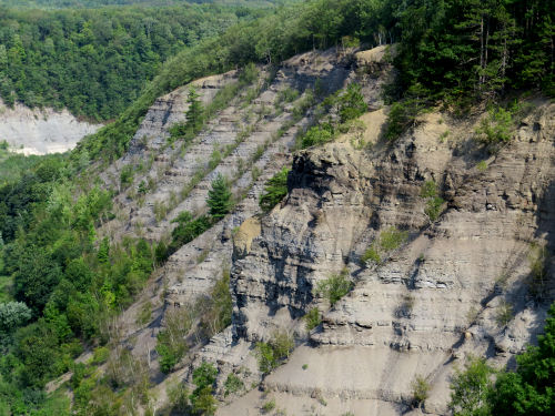
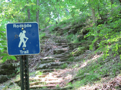
The Rockpile Trail is mostly at the top of the rocky bluffs along the river that I don't have a picture of yet. Of course, the hiker has to get up there!

Rockpile Trail

There were a lot of ups and downs, but some sections were just a pleasant stroll (through the poison ivy).

Rockpile Trail

The biggest trail surprise was a place where there is a deep bay at the edge of the river. The trail comes down to water level and crosses the mouth on a concrete bridge that is used as a fishing pier. There was a man there catching crappie. He said I should go back the way I came and there was a trail that stayed above the head of the bay. I asked him if the bridge connected with the trail on the other side. He said it did, but I'd have to go uphill to get back to the other trail. I told him I'd have to go uphill even if I turned around. I said I wanted to go to the dam, and asked if the trail went on that way. He said he thought it did, but he'd never walked to it. (By now, I was less than a mile from the dam!)

Rockpile Trail

I went on, and got back up to the main trail with no problem, but thought perhaps I'd reached an alternate Oz. There were red brick steps and above them a red brick trail!

Rockpile Trail

Finally, I made it to Wilson Dam. I showed you this four years ago, the last time I was here. This time, I want you to find the pile of rocks below the dam, just left of the center of the picture.

Wilson Dam

The rocks are always covered with white pelicans, cormorants, and great blue herons. Look at the relative sizes.

cormorants, white pelicans, blue herons

I really love the pelicans. This may be my best picture of them yet, even though they are so far away.

white pelicans

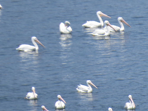
They have a nine-foot wingspan, much larger than the herons. And those black feathers only show when they fly.

white pelicans

I can't keep saving all the wildlife pictures to show you later, or there will be a huge backlog. Already, I have no idea how to share all the new and interesting plants without boring you to death. Anyway, I'll add some wildlife from today. This is a red-spotted purple butterfly. He was kind enough to land on my foot for his picture.

red-spotted purple butterfly

Best picture I've ever gotten of an indigo bunting. Not super great, but not terrible.

indigo bunting

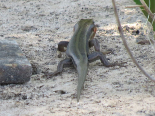
And most exciting for me, a new species to add to my list of animals. This is a five-lined skink. He was running right along that concrete bridge. I had no idea that a- they are so big, and b- skinks are lizards, not salamanders!

five-lined skink

What an awesome day! I completed the hike loop via a paved trail, but there was a breeze so it wasn't too hot. That gave me time to hike the Native Plant Trail too. Total distance- maybe seven miles (the maps didn't indicated mileages).

Here's the trail joke of the day. I needed to use the Energy Trail to connect to the bike trail. I was quite perplexed as to what that name signified. The answer... trail under a powerline!

The poison ivy was crawling out of the trail throughout- coming for me. My first act after returning home was to shower and wash all the clothes. Hope I got everything I touched wiped down.

See Wheeler National Wildlife Refuge
See Wilson Dam
if you like this blog, click the +1   or

Like This!