Entries to Win Afghan

Sign up to receive the Books Leaving Footprints Newsletter. Comes out occasionally. No spam. No list swapping. Just email me! jhyshark@gmail.com Previous gifts include a short story, a poem, and coupons. Add your name, and don't miss out!
Showing posts with label Briar Hill. Show all posts

Wednesday, June 2, 2021

Mash-Up Trail Day

  All day was spent doing trail stuff, but there was a variety. First, I helped spot John, who is going to hike the whole Manistee National Forest. He left his car at Croton Dam, and then I took him to Hodenpyl Dam. He got a much later start than he had hoped. First, he got caught in a traffic jam coming here. Then, I did not realize the Manistee River Bridge on M-115 is closed. Yikes. We had to go all the way back to Coates Highway to get across the river. But eventually, there he was... ready to hike. Wish him well! hiker at trailhead

Then I spent some time on my ongoing trail signage project. There were two possible routes to where I wanted to go. Because I hadn't seen it for a while, I took the spur from the Marilla Trailhead. This used to be the main NCT. But when we got those lovely miles along Hodenpyl Dam Pond, this became just a spur to a trailhead. Nice deciduous forest. deciduous forest with ferns

There are some really nice vistas from this piece of trail. The Manistee River is down in the bottom. vista

Here's Briar Hill again. Highest point in the lower peninsula. vista with Briar Hill

My project involved checking the posts at the junction of the spur with the main trail. I was carrying the shovel, because there was supposed to be a Carsonite post a little farther on to remove. However, one of the 4x4 posts at the junction had broken off. Since I had the shovel, I re-buried it. It's just a little shorter now, but it's OK for a while.

Then I went on to remove that other post. It's no longer there. At least I sure couldn't find it, and I had the GPS coordinates. Anyway, I made it to Eddington Creek, so I knew I was past the location. Eddington Creek

And Eddington Creek bridge. Eddington Creek bridge

Turned around and went back. Then replaced the shot-up Carsonite post and all its stickers at Marilla Trailhead. By then it was 5:30. I decided to just come home. There's lots more to do up that way, but at least I did a little bit. Because most of what I hiked was on a spur trail, not much of my walking counts as NCT miles. But my total for the day was about 3 miles. Hardly a hike, but the day was about projects, not miles.

In other news: Believe it or not, I did manage to sneak in a load of laundry!

North Country Trail miles for 2021 is at 321.

North Country Trail, Manistee County, Marilla Trailhead to Eddington Creek and back. Total 3 miles

See Hodenpyl Dam in Winter

Monday, May 4, 2020

Locating Yourself in the Landscape

 
Maps. I love maps. I love having maps in my head. I love trying to place myself in long vistas, imagining how early peoples located themselves in relationship to natural features.

For example... at one vista from the trail on Saturday, I tried to determine what that white "scar" is in the middle of the view. I'm pretty sure it's actually the sand road leading down to Harvey Bridge where I started hiking that day.

vista from the North Country Trail

Here's the really fun one. Remember how I keep finding views of Briar Hill, the highest point in the Lower Peninsula (1706 feet). Got it again!

The lump just right of center in this picture is Briar Hill from the north, and the little pimple left of it is the confusingly named Briar Ski Hill (1314 feet). Both are near Mesick, MI.

view of Briar Hill from the North Country Trail

Here is another view. In this longer shot, Briar Ski Hill is hidden in the ridges in front of Briar Hill. The other pimple to the left (east) has to be an unnamed hill that is over near Silver Creek at 1251 feet. But this does show how these peaks stand out from the mostly consistent level of the far ridge. In this picture, Briar Hill (the big one) is about 8 miles away.

view of Briar Hill from the North Country Trail

In both cases, I took a compass bearing just to be sure I wasn't trying to see something that really wasn't what I wanted it to be. But when I checked on a bigger map at home, I was right.

Now that you also know what to look for, you can spot those distinctive prominences in several of the other pictures from the last couple of days.

In other news: I worked on projects of mine all day long. I finished the jigsaw puzzle. I made potato-leek soup for supper with some leeks I brought home from my hike. Life is good.

See Pine Valley Preview
See How Many Oxbows?
if you like this blog, click

Like This!

Saturday, April 25, 2020

Teeny's First Overnight - Day 2

 
Day two was warmer, although it still felt raw enough that I kept a jacket on until about the last hour. I'm going to start with the very last picture I took before arriving back at the car. The sun had just come out. This is the same place where I took the picture that was the first on yesterday's post. However, the sunshine makes the view across Leitch Bayou come alive.

Leitch Bayou

The trailing arbutus finally got its act together and agreed to open! Such a delicate little blossom.

trailing arbutus

Here's another lycopodium. I saw three kinds on this hike. This one is Shining Clubmoss, Lycopodium lucidulum. There are two that look something like this, with downward pointing leaves, but this one is shiny. It looks like it's made of plastic.

shining clubmoss

This was a neat surprise for day 2, because I hadn't noticed it poking through on the first day. I saw two clumps of this. It's Lousewort or Wood Betony. Leaves can be this beautiful maroon or dark green. And the flowers can be either yellow or maroon. The leaves will get much larger, of course, about 6-8" long.

Wood Betony

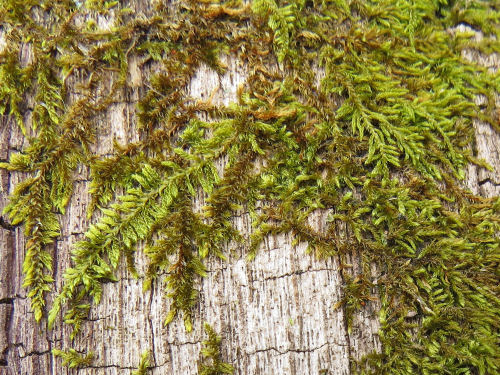
I see this every once in a while, but now I know what to call it. I haven't really gotten into studying mosses. But I believe this is Common Fern Moss, Thuidium delicatulum. At any rate, it's nifty looking.

Common Fern Moss

On this piece of trail, the views across the Manistee River are always hiding behind branches. It's really hard to get a clear view of anything. However, I did find one place where you can really see the twin peaks of Caberfae Ski Resort. And the lingering snow on the slopes verifies that's what it is. They are about 7 miles away. I have hiked here on late winter afternoons when you could see the lights for night skiing. Then you can really identify it!

You can also see Briar Hill, the highest point in the Lower Peninsula, but I could not find a single place where you could get a clear shot of it through the branches. I'll have to keep hunting. Now that I know what to look for, I keep seeing it from "everywhere." This is the third place.

Caberfae Ski slopes

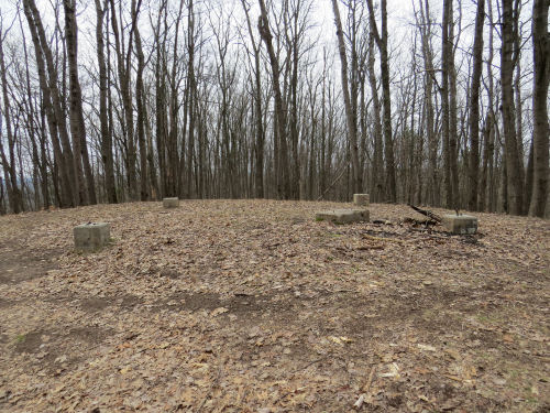
And this is a nifty find, sort of hiding in plain sight. I'd noticed it before, but then I was with a group. This time, I got up there (only a few feet off the trail, but above it, so it's easy to miss). This is the foundations for the Red Bridge Fire Tower. I haven't yet found any more information about it, except that it existed.

Red Bridge Fire Tower foundations

There are 10 good hills in this section. The biggest one climbs about 200 feet. There is one picture I regret not taking. And this is the time of year you'd need to do it. Makes me want to go back before the leaves come out. On a lot of those hills, moss has grown on the vertical part of where the trail is benched into the hill, so as you wind in and out of the crenelated bluffs you can see the green line of the trail tracking and climbing or falling around the head the valley ahead of you. The grade is quite uniform. I'm really impressed with the planning and execution of the trail building accomplished here. A lot of people don't like this side of the loop- the Manistee River Trail is on the other side of the river. There are more open views of the river, to be sure. But I like this side just as much. It's very quiet. The hills are a challenge. The valleys and folds of the sandy hills are pretty amazing. Some of them seem steeper than one might expect of their natural "angle of repose." There are old roads that wander through the valleys. I like to wonder who built those and what was their use.

Teeny did great- She didn't rub any raw spots. I did get a tiny "stich" in my left supraspinatus muscle. I think this can be cured by me getting in better shape. Since I had plenty of time, I made myself take a longer lunch break and read a chapter in the book I had with me. That was a good idea. I usually take a short rest (5-7 minutes) every hour. Marie and I have found this to be a great way to keep from over-taxing joints and muscles. I'm trying to stretch the walks out to 1.5 hours. Each of these two days I did 3 walks of 1.5 hours, and then two of one hour or less in the afternoon as I got more tired. I'm satisfied with my stamina in this regard.

Anyway... I had a great time. I met 6 hikers in the two days. I'm sure there are more over the weekend. This is a very popular section.

Total NCT Miles in 2020 - 168

In other news: Today I worked mostly on some of my many projects.

North Country Trail, Manistee County, Michigan, Sawdust Hole to Eddington Creek and back, 28 miles

See Teeny's First Overnight - Day 1

Friday, June 7, 2019

Pine Valley Pathway Group Hike

 
Only two people came to the hike today, but that turned out to be great because although both of these people have come on hikes before, I didn't know either one of them very well. This gave us a good chance to get acquainted.

hiker selfie

We ended up hiking about 7.5 miles, which was enough for all of use, since the day really heated up. First day that hot here, and it tires you out.

I did take a bearing on that hump (which doesn't show well in this picture), and it just has to be Briar Hill. This is the highest point in the Lower Peninsula of Michigan, at 1706 feet. I've been up it once, but it's all wooded and you can't see much. But I think it's very cool that I can now locate it from several other places.

bearing to Briar Hill

Just off the top of the ridge where I took the bearing you get a much better view of it.

Briar Hill

This would be a better picture if I hadn't made half a shadow, but it's Krigia vriginica, Dwarf Dandelion, which is native.

dwarf dandelion

And the lupine has opened up. It was only in bud when I was there on Monday.

wild blue lupine

We took a break and had a snack on the shore of Lost Lake, as beautiful today as it was on Monday- blue skies are responsible for that.

Lost Lake at Pine Valley Pathway

One more nifty encounter- a bright garter snake.

hiker selfie

In other news: I did a couple of errands after I got home, but with the heat, this was pretty much enough.

See Pine Valley Preview
if you like this blog, click

Like This!