Entries to Win Afghan

Sign up to receive the Books Leaving Footprints Newsletter. Comes out occasionally. No spam. No list swapping. Just email me! jhyshark@gmail.com Previous gifts include a short story, a poem, and coupons. Add your name, and don't miss out!
Showing posts with label vistas. Show all posts

Thursday, August 15, 2024

Nagonaba Trail

 I'm in Paradise-- Michigan, that is. My author friend Jean and I came up together for the Wild Blueberry Festival, and she needed to make a business stop on the way in Northport. Well, if you live in Michigan, you know that Northport is not "on the way" to anywhere. It's almost at the end of the Leelanau Peninsula, a finger of land that juts into Lake Michigan west of Traverse City, forming the Grand Traverse Bay. But it's more on the way than making a separate trip.

I knew Jean had about an hour of work to do, so I had researched if there was some place to take a little walk, and had discovered that they have a small trail system, the Nagonaba Trail. I figured I'd check it out.

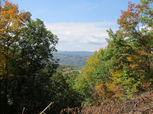
It turned out to be a delightful little place to explore. First off, I walked up to the Scenic Overlook on Braman Hill. You can drive up there, but Jean dropped me off at the parking area. I figured I'd explore as much as I had time for, so I walked up because someone said the view was worth it. From the overlook, you get a view of Grand Traverse Bay. It was a nice vista
overlook of grand traverse bay


I've been trying to find out what Nagonaba means but no luck so far. There is also a Nagonaba Street in Northport, so it may have been a name. I called the museum, but didn't get a human.

The trail is mostly natural surface, nicely maintained. It's multiuse, but not torn up by bicycles.
Nabogama Trail


One section was boardwalk through a wetland, and there was Cardinal Flower blooming. The first I've seen this year.
cardinal flower


Imagine my surprise when I took one of the branch trails to get back to meet Jean and discovered there is a big frog sculpture near Northport Creek!
frog sculpture


I didn't have time to explore quite all of the trail system. There was another nice boardwalk that I would have liked to follow, but I was out of time. As it was, I walked 3.4 miles, and I give the trail system 4 out of 5 stars. It was nicely marked with several maps posted. The park had rec facilities (tennis, pickleball, basketball, toddler playground, skateboard park and clean restrooms). Most of the trail was nicely shaded, and there were occasional benches.

We are set up, with our canopies tied down tight against storms that are supposed to come tonight. We are staying with fellow vendors from Ludington, Steve and Brenda. Bill and Shirley, also vendors from Ludington joined us for dinner.

Miles hiked so far in 2024: 362.0.

Nabogama Trail, Northport, MI, various sections and streets, 3.4 miles

See An Adventure Day

Thursday, July 25, 2024

Sojourner Truth, and, and, and...

 This morning we went to Sojourner Truth State Park. It's quite a new park that was put on the site of a former brickyard and cement factory. There isn't a lot there yet, but we saw most of it. Sojourner Truth grew up in this county, Ulster County. Born in 1797, she was slave to a Dutch family. But she walked away with her infant son and sought refuge with an anti-slavery family. They bought her freedom for $20. She then sued her former owner for the freedom of her son and won! She was the first black woman to win a lawsuit against a white man in New York.

She became known as a speaker, abolitionist, and suffragette. She actually attempted to vote in 1872, although she was turned away.
sojourner truth


There is supposedly a nice dock at river level, but we chose to take the hike to the other good destination at the park, an overlook of the Hudson River. The elevation of the surface of the Hudson here is only 16.4 feet above sea level, yet it's a 2-hour drive from here to New York City. No wonder the tides have an effect here. The elevation from this overlook was 160 feet.
Hudson River


There are several interpretive signs about the former industries. Clay at the base of the cliffs was used to make the bricks, and the cliffs were mined for limestone for the cement kilns. This small lake is a former quarry.
quarry lake


I also learned more about that really bad plant Trapa natans. I'm going to not use the common name "Water Chestnut" as that makes it sound like the Chinese vegetable (although the seeds of this are eaten in cultures where it is native). It's also called Water Caltrop. This is a mat of it on the Hudson River. Maybe we should be harvesting it and trying to eat it out of existence.
Trapa natans


Here's a closer look. The mats are pretty dense. That has to be impacting the ecosystem.


There were also a lot of nice wildflowers at this park. I think they must have been mass planted to be so prolific and concentrated in a former industrial area. It's a mix of Bee Balm (Monarda), one of the wild sunflowers, and a coneflower. They do look great.
mixed wildflowers


We also visited a preserve called Falling Waters (not the Frank Lloyd Wright one- that's in Pennsylvania). This has a nice loop trail and a little waterfall.
falling waters preserve new york


More grocery shopping, a little work time, and then this evening we were finally able to start the project that Marie would like to get done. We started staining her new deck. Hopefully we'll be able to finish while I'm still here. We got one coat on most of the railing.
staining a deck


Miles hiked so far in 2024: 354.6.

Overlook trail at Sojourner Truth State park, 1.7 miles. Falling Waters Preserve loop trail, 1.8 miles

See Saugerties Lighthouse

Thursday, May 30, 2024

An Adventure Day

 Colette invited anyone from our random hiking group, but it turned out to be just three gals: Colette, Sue and me. Our goal was Pyramid Point at Sleeping Bear National Lakeshore. But did we get there in a straight line. No, big NO.


First we made a quick stop at the relatively new Arcadia Marsh boardwalk. We saw over a dozen sandhill cranes, a lot of sunning painted turtles, a muskrat, ducks, trumpeter swans and lots of redwing blackbirds and sparrows.

This post is going to have to be a brief sampler. I chose to share some of the sandhills from that stop.
sandhill cranes


We had to stop at the Arcadia Bluffs overlook, because who can drive past that on a nice day? This is looking south from the top of the overlook, and the marsh trail we had just walked is down in the valley between this point and the far bluff.
Arcadia Bluffs Overlook


Then we decided to swing in to the Point Betsie Lighthouse since I'd never been there.
point betsie lighthouse


OK, we finally made it to the Pyramid Point Trail. Looks harmless enough, right?
hikers


It wasn't terribly hilly. Only about 100 feet total elevation change, but the final climb up to Pyramid Point was steep. From Pyramid Point you look out over Lake Michigan from 375 feet above the water. It's considered to have one of the best views of Big and Little Manitou Islands. I didn't do a very good job with pictures of that. I was too focused on the amazing color of the water. But that's Big Manitou on the right side of the picture, and Little on the left.
pyramid point view


We had planned to hike the loop trail there after going to the lookout point. This turned out to be the big wonderful surprise of the day. The trail is through rich woodlands and we saw something like 15 species of flowers in bloom, not to mention ones already gone to seed. I'll just share the best (to me).

Jack-in-the-pulpit was everywhere. We weren't sure if we'd ever seen so many in one place. This was my favorite.
jack in the pulpit


I love the yellow lady slipper orchids even more than the pink ones.
yellow lady slipper


Botanically, this was the best find of the day, although there is so much greenery going on that it's hard to know what you are seeing. This is rattlesnake fern, Botrychium virginianum, one of the moonworts. It's the most common of that group, but still a very nice find. It only grows in moist, rich woodlands. It has a Coefficient of Conservatism of 5.
Botrychium virginianum


All that, and it's not yet 2 pm. So we went to get some lunch.

Still not satisfied, we hunted up one more little trail that none of us had ever been too. That was a feat in itself because one or the other of us had been to almost every one of the 46 hikes in the Jim DuFresne book of Hikes Along M-22. We found the Portage Point Nature Preserve Trail, which I think has to be relatively new. It was a quick hike of a little more than a mile through more typical dry woods. But it was a great ending to the day. Just to emphasize how interesting the previous trail was, we did not see a single flower blooming along this trail.
Portage Point Trail


Was this the end of our adventures? Well, almost. Colette veered off in Manistee. Then Sue and I stopped to look at plants. Yes I came home with plants. More on that another day.

Now we are at the end. We think the total miles hiked is about 5.5.

Miles hiked so far in 2024: 249.2.

Arcadia Marsh, about 1 mile. Pyramid Point Lookout and Loop, about 2.8 miles. Portage Point, 1.25 miles. Miscellaneous at Betsie and the Bluffs ? But we are calling the total 5.5

See Shiawassee National Wildlife Refuge

Thursday, January 25, 2024

Rainy Day Fun

 It rained most of the day, but we managed to have some fun. In the afternoon we went for a drive so they could show me the town. We ended up on a ridge with quite a view.
view from Morris Winery


It was stunning... taken in the more literal sense. I was stunned. I had no idea we were so close to actual mountains. This is the western edge of the Appalachians. Also stunning as in gorgeous, even in the fog and mist.

I'm pretty sure the ridge right in front of us is called Chilhowee Mountain.
Chilhowee Mountain


I love the shades of the layers of hills. The mountain is about 10 miles away.
Chilhowee mountain


Let's zoom in once more for even more varied layers. Don't be fooled into thinking the blue-gray is sky. Look at the top. The sky is white. That gray is Chilhowee Mountain. Actual elevaton about 1800 feet.
Chilhowee mountain


It's a lot of pictures, but I have to show you Sugarloaf Mountain (what else, right?). It's just so cute sitting out there all alone. The Ocoee River flows between it and Chilhowee where it is dammed to formed Lake Ocoee.
sugarloaf mountain tennessee


Other than that, we did puzzles. We were talking about the rabbit puzzle I got for Christmas. Well, Lin has some of the puzzles like that made by the really good company, Liberty Puzzles. We had to get one out.
woman doing a jigsaw puzzle


There are many interesting pieces in these puzzles. Here are just a few. Sometimes you even had to combine several pieces to make the shape- for example there were about 6 pieces that made a car. There was a woman sitting at a table with a teapot and that was four pieces. And the shapes have nothing to do with the picture on the puzzle.
Starry River jigsaw


I loved this picture. It wasn't quite as hard as I thought it might be. We started last night, and I finished it this morning while Lin had a prior commitment. It's called Starry River.
starry river jigsaw puzzle


Not content to quit with one, we did another one this afternoon. This was easier. It's called Grizzly Bear. In this one, most of the animals in the picture had a shape piece of the animal that was also part of the picture. The frog had a frog shape in the middle, likewise the eagle and the porcupine, and more.
grizzly bear jigsaw puzzle


These are really high quality puzzles, and it was a treat to get to do a couple.

Joe has made some wonderful meals! They eat a lot of veggies, and you know this made me happy too.

Tomorrow I'll be back on the road.

See Bradley County Greenway

Tuesday, October 10, 2023

Gore Mountain


The afternoon of the day we went to Fort Ticonderoga (September 30), Marie and I did not return to the Celebration on the bus. We played hooky with Larry and went up the Gore Mountain Ski Area gondola. It runs all summer as a tourist attraction, and mountain bikers use the trails too.
Gore Mountain ski lift
people in ski lift gondola


The pictures from the gondola aren't as good because the plexiglas was very scratched, but this is looking down the lift.
Gore Mountain ski lift


There is a total of 1700 feet of rise from the bottom to the top. Needless to say, the ski resort has a number of lifts, but this is the popular one for tourists.

Now this is what I call a view! The blue peaks in the distance are the High Peaks. One of them is Marcy [high point in New York]. I could pick it out in person, but in the reduced size picture, I'm not so sure which it is.
high peaks from Gore


Since we could see Gore Mountain from the Moxham Mountain hike, I asked if you could see Moxham from Gore. The lift operator told me where to look on the way down. I think that cliff standing out by itself is Moxham. You know I love figuring out how I fit into the landscape.
Moxham Mountain


The name Gore Mountain has nothing to do with being bloody. At the Adirondack History workshop I attended at the Celebration, we learned that the whole central portion of the Adirondacks was surveyed not on N-S lines, but at a 45 degree angle to that. So where that area adjoins other areas surveyed in the normal manner, there are triangular sections. If you have ever sewed clothes, you probably know what a gored skirt is... a skirt made from triangles. Gores are also inserted in things like sails. Guess what those triangular sections of land were called. Now guess where Gore Mountain is located. I knew you could do it!

Well, ok... there is probably some etomological relationship between the meanings. They both may hark back to German and Old English where various forms of gehre and gar meant a spear or a spearhead, which are triangular, and the use of such an item to gore someone resulted in bloodshed... to be gory.

I edited in the day, and had a program this evening. That's enough for one day!

See Fort Ticonderoga

Monday, October 2, 2023

Step Two Homeward


Now I have a friend in my hometown who also likes to hike! Diane and I were a few too many years apart as children to really know each other. Now it turns out that we like a lot of the same things.
friends


We had time for a short hike before I had to hit the road, and she took me to see a piece of rail trail so new it's only been open for about 10 days. This was a section of the Lehigh Valley system. Only 2.3 miles are open yet, but it may get extended.
Odessa rail trail


This line stayed high on the hills for frieght. The passenger line had to stay low to go through Ithaca at the south end of the lake, 500 feet lower down. That means there are some great views. This is the valley south of Watkins Glen, and we think the water there is the south end of Seneca Lake.
vista


I liked this one a lot with hills and a farm.
farm in a valley


Then I hit the road and went across western NY. I've shared a lot of views of this drive in several seasons, over the years. All I could get is some drive=by snaps out the windos, but this one is OK. Just the hills I love. Sure, it's not the Adirondacks here, but it's still great. The afternoon light made the trees glow, and the colors are fantastic this year.
new york hills


And I arrived at blogger-friend Ann's house to spend the night.


Odessa, NY. Bruno Schickel Rail Trail. 2.3 miles

See Time to Leave

Thursday, September 28, 2023

Moxham Mountain


Marie and I signed up for the Moxham Mountain hike. The primary reason was because I wanted to see something that was new to me. It turned out to be a wonderful choice.

In the bus, on the way (picture taken through window), we had this view of the entire mountain. We were getting ready to hike from right to left up to the little hump, down into the saddle and then to to top of the hump with the sheer face.
Moxham Mt


Even part way up, we began to have nice views.
Adirondack view


Part way up the little saddle, we could see the cliffs of the south side of Moxham. Yes, we are hiking to the top.
Moxham Mt


The trail got rockier, with a lot of our walking on ridges and rock outcrops.
hiking up Moxham Mountain


Finally, we were at the top and were rewarded with this spectacular view! The existing North Country Trail is on the front ridge on the opposite side, with the Hudson River in the bottom of the valley.
view from Moxham Mt


Here is the lodge at the camp where the Celebration is being held. We have tents or bunkhouses for sleeping.
Forest Lake Camp


Last night we heard a talk by the Deputy Director of the Adirondack Mountain Club. It was very informative, and they are welcoming the NCT to the Adirondacks. Believe me, our trail would not be here without that acceptance.

See On the Way