Entries to Win Afghan

Sign up to receive the Books Leaving Footprints Newsletter. Comes out occasionally. No spam. No list swapping. Just email me! jhyshark@gmail.com Previous gifts include a short story, a poem, and coupons. Add your name, and don't miss out!
Showing posts with label Vermont. Show all posts

Thursday, June 16, 2022

Halfway - Celebrating with Kevin - Day 198

  My new friend (and NCTA Board member), Kevin Russell, wasn't sure he'd be free when I arrived at Maine Junction. He said to let him know when I could predict the time, which I did. hikers at Maine Junction

As you can see, he made it! But all morning, as I was hiking toward that destination, I was thinking it would be nice to have someone to celebrate with. But then I told myself that I do all kinds of things alone, and that is fine too.

But, I was pretty happy to see him hiking toward me just as we reached the shelter that isn't far from my goal. I was way overdue for a break, so we stopped long enough for me to eat a snack and drink some water. By the way, that is the Tucker Johnson Shelter- a nice one with bunks. Tucker Johnson shelter

How much farther to go? 0.4 mile! trail sign

And very quickly (easy trail downhill), we were there! What's the big deal about Maine Junction? This is where the Appalachian Trail splits from the Long Trail and heads toward Maine. It's also now (since 2019) the eastern terminus of the North Country Trail. So, it's a triple point where three major trails meet. No, we are not mentioned on the sign yet, but eventually... sigh. Lots of politics even for trails.

This is approximately the halfway point of my hike. It's the second time I've hiked to here (Marie and I did this in 2014) before it was official, and even though it's just a signpost in the woods, it's a special place. Maine Junction

However, unless you want to spend the rest of your life in the woods, you have to hike one more mile out to the trailhead at the road!

Kevin has been SO generous. He brought me a wonderful chicken salad for lunch... person eating deli salad

...and a sandwich for himself. person eating a sandwich

It was really fun to have someone to celebrate this milestone (milepost?) with me.

He had afternoon commitments, and I had to start driving west. I'm already back at Mary's, snug in Sunny, and now I have to decide how far I think I can drive tomorrow.

Miles today that count: 6.6. Total miles so far: 2450.4. Miles that don't count- the 1 extra to the parking lot.

Chittenden Tributary to Maine Junction (and on to Route 4), Long Trail, Vermont

Wednesday, June 15, 2022

Long Trail - Day 197

  As it turns out, I didn't end up with many good pictures from this day. A lot of the Long Trail is closed in by trees. There were hints of views and a lot of ups and downs. Someone had left a greeting on an artist's conk fungus. hello on artist's conk fungus

I caught a nice picture of a tiger swallowtail butterfly visiting Clintonia. tiger swallowtail

And the one real view is of Chittenden Reservoir where there are open rocks and no trees to obstruct the scene. Probably every hiker has this same picture, because it's the only one in this stretch worth taking. Chittenden Reservoir

I got the answer to where there is reliable water. A good creek is always near a shelter. Stated another way, after I got back to Mary's, she asked me the frequency of the shelters. The answer is, there is a shelter at most every reliable water source. This spaces them rather randomly, but you can count on water.

I camped just past an unnamed stream that flows to Chittenden Reservoir. It might also be reliable, but there was not a shelter there. I don't care for the shelters to camp in anyway. I prefer my tent.

Miles today: 10.6. Total miles so far: 2443.8.

Sunrise Shelter to Chittenden Tributary, Long Trail, Vermont

See Gilespie Peak

Monday, June 13, 2022

Moosalamoo - Day 195

  Say MOOSE-ə-luh-MOO. This is a National Recreation Area within the Green Mountain State Forest in Vermont. It covers almost 16,000 acres, and was designated a Wilderness in 2006. It was there when Marie and I hiked Vermont in 2014, but I didn't feel confident that I could get good enough maps of the trails to cut through it at that time. So we just hiked the road up to Middlebury Gap and got on the Long Trail there.

In the center of this wilderness is Mount Moosalamoo, at 2600 feet. Not a huge mountain, but from the parking area it's a 2000 foot climb. This is not to be scoffed at!

This time, there is a chosen route for the NCT through Moosalamoo. I even got a map. The NCT route does not go all the way to the top of the mountain, but it does climb 1700 feet.

I was delighted to find that some of the trail is even blazed for NCT trail sign

This trail is also used by mountain bikes. Their club has done some impressive trail work, especially a lot of rock work. stone rock work in trail

In an open area, I caught a Viceroy butterfly. They look a lot like Monarchs, but have that extra black line across their hindwings. Viceroy butterfly

Kevin met me at the campground- near the middle of the day- and brought me wonderful deli salads for lunch. Then he hiked with me part of the afternoon. That was great because he knew exactly which turns to take, and the east half was not NCT blazed. He kept trying to talk me into coming to spend the night at his house. He didn't like my footwear (neither did I, but that's another story), and he wanted to take me to an outfitter to get better shoes. friends

We did not reach the turn to climb up to the Long Trail until after 4 p.m. That was another 800-foot climb, and I let myself be talked into going home with him, even though it would add another day to my hike.
hiker at trail sign


Since he fed me lunch, dinner, and breakfast, I had enough food that the extra day was not a problem. And dinner was yummers! burgers on grill

Now for the rest of the story of the day. Last things first, we did not find a pair of shoes that fit me. That's the story of my life. Kevin was really unhappy that I would not buy a pair of shoes, but I insisted I'd be fine (very uncoachable, you see).

Kevin's presence did greatly encourage me.

For some reason, I was having a really tough time this day. Perhaps I didn't realize how long the climb up Moosalamoo would be. It was so discouraging. There were a lot of small switchbacks. Switchbacks are a good thing, but I kept looking at my shadow and grumbling, "Why am I going north againn?"

It was hot and the mosquitoes were thick. I was back in the headnet and long sleeves again. The forest was very closed in, and views were not on the menu. I was unusually tired, and feeling perhaps not fully positive about going into unknown woods backpacking again. Strange feeling for me, right?

Anyway, I started singing, "His strength is perfect when our strength is gone. He'll carry us when we can't carry on. Raised in His power, the weak become strong. His strength is perfect; His strength is perfect." (This is only the chorus. You can hear the whole song by the singer who made it well-known at His Strength is Perfect)

What a great message for ME. You all keep telling me how amazing I am, and maybe I was starting to listen to you. I am only stubborn, and willing to keep putting one foot in front of the other. I'm old, I'm weak compared to what I was even a few years ago, but I'm being allowed to do this epic hike (it has begun to feel a little epic), and all I have to do is keep letting Him carry me.

No one has an accurate mileage for this section yet. I estimated 11.2 miles by measuring the trail lines on a topo map. I think it has to be more than that. I should have turned on the tracker in my app, but I didn't know I'd be going to Kevin's where I could have easily charged up my power pack. I'll go with the measured distance. It was certainly at least that.

Miles today: 11.2. Total miles so far: 2425.7.

Oak Ridge TH to Sucker Brook Trail, Vermont, Moosalamoo

See Trail Around Middlebury

Saturday, June 11, 2022

Welcome to Vermont -Day 193

  The day began by walking across the Crown Point Bridge. It's about a half mile long. Crown Point Bridge

Here's a side view of the whole thing. It's a really lovely bridge, and it has pedestrian walkways on both sides.

Just in case you don't know the story behind this, the previous historic bridge was built in 1929. You can see it at We Hiked. But in 2009 it was inspected and immediately closed. They blew it up! Then they built this new bridge. "We" were afraid it was going to be some ugly, utilitarian thing, but instead we got this beauty, and its designed for walkers as well as vehicles. Crown Point Bridge

I sort of fudged when I said New York was complete a few days ago. Technically, the line is in the middle of the bridge, not at this sign.
Welcome to New York sign


Now it's official- I finished New York and entered Vermont Welcome to Vermont sign

Just because I finally got a picture of one, I've been seeing hares, and I'll show you. These are not really rabbits. They are bigger and just look different. This one wasn't too big- s/he might have been young. hare

Mostly what I loved about today is the views of the mountains. I just couldn't stop taking pictures of them, even though I can't identify what I'm seeing. When you look back to the west, you see the Adirondacks. Adirondacks

When you look east, you see the Green Mountains. In two days, I'll be up on top of those! Green Mountains

This valley between the two ranges of mountains is actually part of The Great Valley which extends all the way from Quebec to Alabama!

Miles today: 15.7. Total miles so far: 2397.2.

Crown Point Bridge to Bittersweet Falls Rd, Vermont.

See Out of Sequence

Tuesday, February 26, 2019

North Country Trail Amazing News

 
For over 20 years the North Country Trail has been working to have the route in Minnesota officially (by Congress, as required) to include what has been nicknamed the Minnesota Arrowhead. This extends the trail along the north shore of Lake Superior via the Superior Hiking Trail, then west on the Border Route and the Kekakabic Trail through the Boundary Waters Canoe Area Wilderness, and then back down to the center of the state at Grand Rapids, MN. Even the National Park Service has been accepting this route for years, but it still wasn't official.

A few years ago, the Appalachian Trail also finally decided they wanted to connect with the NCT, and this also required Congressional approval.

Last week, the Senate passed a recreation bill which included this "route adjustment" provision. This was the first time EVER the bill had made it through the Senate. For the past few years, the House had passed a version of the bill, but it needed to get through both houses.

Today, the House voted yes on their version, and now it only needs to be signed into law. Seems like this will happen, but we have a tiny bit of finger crossing to do for this last step.

This is HUGE!

Scenes from the included portions. Maine Junction where the NCT will join the Appalachian Trail. This is also part of the Long Trail.

Maine Junction, North Country Trail, Long Trail, Appalachian Trail

One of the views from the Vermont portion in the Green Mountains.

 North Country Trail, Long Trail, Green Mountains

A view from the Superior Hiking Trail along Lake Superior in Minnesota.

Hellacious Overlook, North Country Trail, Superior Hiking Trail

Waterfalls on the SHT and NCT.

Waterfalls, North Country Trail, Superior Hiking Trail

Mountain Lake on the Border Route, looking into Canada.

Mountain Lake, North Country Trail, Border Route Trail

And Agamok Bridge on the Kekakabic Trail.

Agamok Bridge, North Country Trail, Kekakabic Trail

These will now all officially be part of this great trail experience. Can't have a better quality day than this!

See The Party's Over, But it's OK
if you like this blog, click the +1   or

Like This!

Friday, June 27, 2014

NCT Vermont Extension- Long Trail Day 4

 
This was our last day for this hike, and truth be told, we probably could have hiked out the day before. But we didn't want to. (I can't speak for Marie, actually, but I didn't want to, and she knew I didn't want to, and she likes me.) So we had one last night in the woods, and awoke to a lovely morning despite going to sleep in the rain.

tent in morning light
There were just four miles to go to reach the car, and only three to make it to the big goal, a place called "Maine Junction." That's just a fork in the trail where the Long Trail and Appalachian Trail meet (for southbounders) or split (for northbounders). It will eventually be the new eastern end of the North Country Trail.

We were feeling happy and the trail was relatively easy. There was a steady uphill for the first couple of miles, but it wasn't difficult. We rested at a bivouac area.

hiker selfie

Even the trail markers were happy! And if you were wondering, the Long Trail is marked with white blazes.

smiley face

Before we knew it, there we were! Maine Juction, and two smiling hikers.

Maine Junction

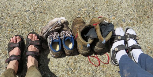
We'd passed quite a few hikers on the Long Trail, all NOBO (northbound), over the past few days. In the final mile to the car on the shared trail, we passed one hiker. I asked him if he was hiking the Appalachian Trail or the Long Trail, and he said the AT. But he was clearly intent on moving along and we didn't chat. We reached the parking area just before 11 am. First priority at the car? Let the feet out, of course.

boots and sandals

The next priority? Iced tea and a nice meal. We went to the Rochester Cafe, in, duh, Rochester, Vermont. Recommended!

restaurant meal

Here's the map. The Long Trail and our route is in red; the AT is in white.

Long Trail Map
See Long Trail Day 3
if you like this blog, click the +1   or

Like This!

Sunday, June 22, 2014

NCT Vermont Extension- Long Trail Day 2

 
How about starting with some explanation. The Long Trail runs the north-south length of the state of Vermont (Massachusetts to Quebec), for 273 miles, along the ridge of the Green Mountains. It's concurrent with the Appalachian Trail for the southern third. In this overview map, you can easily see the string of mountains. For reference, our hike is marked with yellow for road walks and red for trail, with the red strip on the eastern end the Long Trail Portion.

Long Trail
As I've not let you forget, we had to get creative to finish this hike together. So, Monday morning, we took down the tent and began re-organizing to see if my pared-down pack plan would work. The yellow tarp is just to keep things organized and clean (we weren't going to carry it), and the plastic box wasn't going along, but the contents were- the food. After my night-time machinations about what to leave out, we took out even more, including some of the food (we'd been eating less than usual too), and my fanny pack, just keeping a few essential items usually carried in it like the compass and insect repellent.

packing gear

Did it work? We got everything in Shamu, and Marie's daypack, and weighed them. I had 28 pounds and Marie had 15. This was definitely do-able. We even took one non-essential- our card game.

packed gear

Then we had to drive to the starting location, but even so we started hiking southbound at 9:45. Not great, but not bad with all the prep time. We hoped to make it seven miles, just past the David Logan shelter and then find a place to camp, but if that was too far, we'd take whatever adventure came to us.

The first and biggest climb of the day was about 950 feet to Bloodroot Gap. But we were thrilled to discover that the grades were much easier today. The first 2.5 miles were a very gentle climb.

Long Trail

Nevertheless, recall that I haven't backpacked in four years, and was sick before this trip, and still wasn't 100%. For most of the day we stopped every half hour for a short break. This is all humiliating to admit, but I'd rather walk 30-minute stretches than not walk. In an hour and a quarter, we'd covered 2.3 miles, and reached this marker. It's nice to have markers, so you can track your progress, even if you are going slowly (that's way slower than our usual pace).

Long Trail

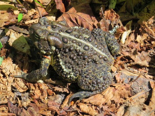
Even with Shamu on my back, and lower stamina, the weather was awesome, and nothing could keep me from enjoying this. We saw quite a few toads, but this was the first, and it was perhaps the largest toad I've ever seen, outside of a zoo. It was the size of my fist!

toad

There was no sign actually marking Bloodroot Gap, but this may have been the view from it. It's really a high col between Farr Peak and Bloodroot Mountain.

Long Trail Vista

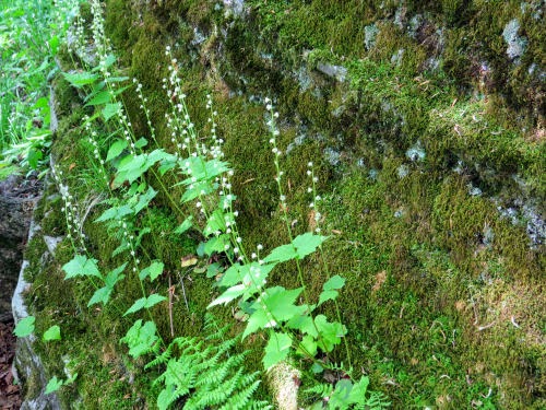
The afternoon was a series of ups and downs, none of them awful, but they were somewhat frustrating because the reality didn't match the elevation profile on the map very well, which suggested that section of trail was going to be mostly a descent. There were innumerable lovely rock gardens, this one filled with miterwort.

miterwort

We finally passed the shelter turnoff, and began looking for a place to put our tent. Dispersed camping is allowed, and the black fly and mosquito populations guaranteed that we wanted to be zipped in the tent.

We did find a lovely spot. Miles for the day, about 7.2.

tent

Camp chores include hanging the food out of the reach of critters. The flies didn't get the food, but they were working hard on me while I got it hung.

camp cache

Taking it slow was a good idea for yet another reason. This was like a second ending of the North Country Trail... after my "big deal" final hike in 2010. Of course, I never want the hikes to end, and this allowed us to prolong the adventure a little longer. We enjoyed the mild evening and played our game protected from the biting vermin.

Long Trail map
See Long Trail Day 1
if you like this blog, click the +1   or

Like This!