Entries to Win Afghan

Sign up to receive the Books Leaving Footprints Newsletter. Comes out occasionally. No spam. No list swapping. Just email me! jhyshark@gmail.com Previous gifts include a short story, a poem, and coupons. Add your name, and don't miss out!
Showing posts with label Manistee & Luther RR. Show all posts

Monday, October 27, 2025

Exploring Old Grade


Today was pretty busy, but it was all good. In the afternoon, I stopped at the "Old Grade Campground" (Manistee National Forest). It's only the second time I've been there.

Can you guess how it got its name?
old rail bed


Yup! It was a railroad grade. But you know I can't be content with only knowing that. I had to know what railroad. This is not far north of the village of Peacock where two separate railroads crossed each other. However, it is on the north side of the Little Manistee River. So I couldn't quite figure what railroad this was.

Turns out, it's a logging line of the Manistee and Luther RR. Their main line went from Eastlake to Hoxeyville (never quite making it to either Manistee or Luther!). On the map, the red lines are Manistee and Luther. The topmost of the dark green arrows points to where I was today. And that means the railroad had a bridge across the river there. I wonder if one can find any remnants.

The lower dark green arrow points to Peacock where the light green Michigan E & W line crossed the Chicago and West Michigan line in magenta.
railroad map near Peacock michigan


I was hoping to write about the loop trail at Old Grade for one of my columns. I have to think about whether I should do that. Some of the trail is in bad shape. I made it through with electronic help. The good portion could be done as an out and back. Anyway, I had fun. Here's where the trail begins.
trail marker


When you get around on the other side of the loop, the trail briefly follows a small, unnamed creek that flows beneath hemlocks to the Little Manistee River .
unnamed creek


Here are a couple of closeups. Red maple leaf- not just red in color, but it's a red maple.
red maple leaf


And some needles from a white cedar which fell artistically on its horizontal trunk. I suspect squirrels bit these off and dropped them.


This all happened after I met with some people about some trail stuff, and I also did laundry. I worked on computer stuff a bit this morning, and my day was completely filled!

Miles hiked in 2025: 410.4

Old Grade loop trail and in and out from entrance 2.3 miles.

See Not Quite, But Quite All Right

Saturday, February 24, 2024

Serious Railroad Sniffing

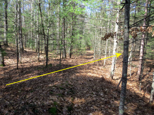
 I had to go to Fountain this morning, halfway to my section of trail anyway. The ground is still dry, and this morning, also frozen (18 degrees) which turned out to be a good thing. Exploring that railroad berm just called to me. This is the picture I showed you on Thursday. On this picture the RR is yellow and the trail is blue.

Manistee and Luther Railroad spur

My sense is that it's a spur of the Manistee & Luther RR, which operated from 1885-1913, for only 28 years. This seems short, but it was actually the longest operating line of R.G. Peters (local folks have probably seen interpretive signs about his railroads at Nordhouse Dunes). But I haven't actually connected it up yet. If it is, this spur does not show on the only map of the M&L route that I have. I've recreated parts of that map here, so you can see it in relation to the trail.

The yellow lines are the known M&L routes. It's a fact that it followed 9-Mile Road from Eastlake, all the way beyond 9-Mile Bridge, and then at some point left the road and continued south of Dublin and farther east to Hoxeyville, the eastern terminus of the main branch. This route even shows on old topo maps.

The southern route crossed the Little Manistee River (seems to be west of the current 9-Mile Bridge, but I'm not positive about that because the map I have has a line about a quarter of a mile wide), angled southeast, and at Koenig Rd (FR 5331, Dead Horse Marsh Rd) split again. One branch angled ENE along what is now the aforementioned road, and also continued SE. This branch includes the lovely shaded rail bed just north of the Freesoil trailhead that I often show you pictures of (MI-836.5ish). This is the branch that may have actually reached Luther.

The purple line is what I found today.
partial map of the Manistee and Luther Railroad


So, what I did today was park on Tyndall Rd near where the known berm crosses the trail. Then I began bushwhacking. I knew that section might be hard to spot. I'd tried before. No dice. I wandered around without finding it and made my way to the known place where it crosses the trail. First picture above. Then I followed that berm.

It quickly disappeared. More wandering. Then I found it! Some sections were in cuts.
Manistee and Luther RR cut


Other parts were clear berms.
Manistee & Luther RR berm


It was places like this that I am glad the ground was frozen today. Here I could not walk on the berm because that is where the trees have grown, so I had to stay down beside it where I'll bet it's pretty wet at some times of the year.
Manistee & Luther Railroad berm


In other places, where the rails were laid at grade you could hardly tell where it had been. (straight ahead)
small pines in woods


Another piece made me glad it was dry and frozen. The route was overgrown with leatherleaf- a sure sign that there is water very near the surface.


Also plenty of sphagnum moss there- also a wetland species.


I continued northeast and then it turned slightly to the north and "ended" at a dirt road which I think is now private. I'm pretty sure that road was the old rail bed. My guess is that it continued north until it hit the middle route before that route crossed the Little Manistee River.

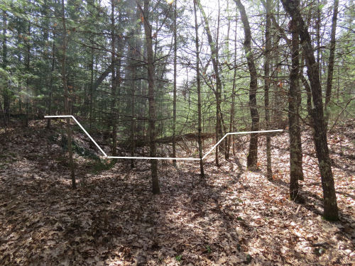
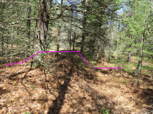
Then I turned around and followed it back to the trail crossing. I did manage to find the route that entire distance on the way back although it does become very unclear where I had lost it outward bound. So, how do you find an old rail bed? You've seen the cuts and berms. You know that railroads have to be close to level. You know that they can't make sudden turns. Here's another clue, and it helped me find that missing piece. The beds were made level by digging "borrow pits" along the way to get fill dirt. Even though this was built 150 years ago, you can still see a lot of those pits. I've circled a couple here in pink. But which clearish space is the rail bed? Yellow or purple? It was the purple one. I was aided by knowing the spot where I was headed, and I could also see some pits on the far side.
old railroad borrow pits


When I got back to the trail, I tried to continue south. I hadn't had much luck before, but those times it was summer and there was a lot of undergrowth. I was able to follow it today. I only went as far as my car. I need to go back one more time and make sure it connects with that southern line (the part that goes through the swamp). Then I'll be sure this was a Manistee and Luther spur. The M&L was a narrow-gage road (the rails were 3 feet apart) and hastily built. It was known for having lots of derailments and accidents. And yet, 112 years after the last rail car rode this route, I am able to follow its path through the woods!

Where it crosses the trail is near MI-835.5 What I walked today is in blue here. (Sorry about the inconsistent colors)
possible spur of the Manistee & Luther RR


Here is my Avenza track. I only walked about 3.3 miles, but remember I was semi-bushwhacking at best when I was on the route, and fully bushwhacking when I lost it and had to find it again. Unique miles followed on the railroad berm was about 1.5.
Avenza track


Total miles hiked in 2024: 116.6 of which 23.7 is North Country Trail.

Bushwhacking a spur of the Manistee & Luther RR. About 3.3 miles

See Couldn't stay inside

Saturday, October 7, 2023

Hikin' in the Rain


To my knowledge there was no singin' or dancin' involved, but hey, we didn't have Gene Kelly along.

However, nine of us decided that rain didn't matter. Two of the people were brand new to our group. We call them Intrepid!
hiking group in rain gear


All the rain gear made us a colorful bunch. Koa, Loren, Glen, Steve, and I walked together quite a bit.
hikers in the rain


Just a tiny maple tree, turned bright red.
small red maple


The most interesting thing was the way this bracken fern is losing its color. I like the pattern.
bracken fern fall


I also hunted down an unmarked railroad berm that I've showed you before. I lost all my waypoints when I updated maps. Note- if you use Avenza, it's safest to export your tracks and waypoints that you want to save before you update. Then if they don't come through, you can import them back into the map.

North Country Trail, Freesoil TH to Tyndall Road and back. 5 miles.

See SPW August Hike
See that rail berm in winter
See When I found it

Thursday, December 17, 2020

Embarrassing Trail

  Today, Loren and I hiked south from the Freesoil Trailhead on the North Country Trail. The snow we had on Friday was wet and heavy, and it has continued to stick to the trees, weighing them down. But when we started, the pathway was still clear. Other people have hiked it since the snow fell which also helps. snowy trail

However, the farther we went, the fewer footprints there were. And the blazing... well, the blazing had not been repainted in way too long. Here's a tree with a blaze. tree with a very old trail blaze

What? You can't see it. Look closer. There's a bit of blue paint hiding in the bark. very old painted blue blaze

Yeah, that's what we ended up looking for. And the branches were all bending into the trail. In this picture you can actually sort of see the trail. That didn't last. We decided we didn't feel like bushwhacking where we had to keep ducking under branches that dumped snow down your neck. We were now past where anyone had walked, so we were just hunting for old blue paint with no real help. This is why it's embarrassing. This isn't my personal section, but it belongs to my chapter, and this is just unacceptable. A hiker should be able to follow the blazes even if the treadway is covered with snow or leaves or whatever. Maybe I can help whoever has adopted that section in the spring.

We did walk 2.5 miles before we turned around. snowy trail

After Loren left, I decided to go north from there on my trail section. Since I'd just repainted the blazes in the spring, I knew it wouldn't be as bad. Well, I still had to duck under an awful lot of bent trees, but you could easily tell where the trail was. And you could always see a blaze. This is the view into the bottomland hardwood swamp that runs beside the first half mile. bottomland hardwood swamp

My goal was to make it to the old and unidentified railroad berm that I showed you back in March (link below). It was almost exactly 1.5 miles in. This time, I marked it on my trail app. Again, here's the view to the left (when you are walking north on the trail) which goes into a cut. old railroad cut

And here's the view to the right which is on a berm. old railroad berm

I decided to collect one more piece of information. Loren and I have been talking about trying to follow the old grade to see where it comes out. My thinking was that this was a spur of the Manistee and Luther RR. That still could be correct, but when I put the compass on it... wow! The trail actually angles slightly to the west there, and the railroad grade is almost exactly north-south! Now I'm really confuzzled.

I walked just a short distance on the berm and dropped a pin on my trail app on my phone. Then I did the same going the other direction in the cut. Yup- north-south. It parallels Tyndall Road, which is the border between Mason and Lake Counties. But it's really close to the road. Following it with all the saplings bent down isn't going to be any fun. We'll wait for better conditions.

I have spent about another hour trying to sniff out what this line might be. It almost has to be a railroad grade. The berm continues north past where I walked. The cut doesn't last very long, but quicly becomes a berm as the land drops gently to the south. They just didn't bother to grade road beds to that extent. Only railroads had to be so level. I did find a line for a two-track road on an old topo map that might correspond to this. So perhaps it was a logging spur, and then when the rails and ties were pulled up it became a road. There are SO many little bits of lost history like this. Those logging spurs were so ephemeral, they just laid them down and tore them up willy-nilly after the trees were cut.

Anyway, I hiked about 8 miles in light snow. I thought I might be a little sore, but I'm not. Hooray!

North Country Trail miles this year: 258

In other news: I did some editing, and pondered this railroad grade, yet again!

North Country Trail, Lake County, Michigan, south and north of the Freesoil Trailhead, and back.

See Railroad or Road

Saturday, March 28, 2020

Railroad or Road?

 
Can you believe that I discovered something new on my North Country Trail section this week? It's true. I guess I'd never hiked it at the exact right time of year with no leaves, and/or maybe with the light right for me to see it. Or maybe I was simply being unobservant.

At any rate, I found a worked road or railroad bed that cuts across that section of the trail. But what is it? I'm afraid that in the pictures you can't really see much of what is obvious when you are there. Well, not so obvious, I guess, since I've walked this piece probably 50 times, and never saw it before.

Here is the trail, going straight up the middle of the picture. I've marked the other grade in yellow.

grade crossing a trail

When you stand in the trail and look SW (to the lower left of the picture), there is clearly a cut made for some sort of transportation. I've marked the edges of the cut in white.

road cut

When you stand in the trail and look NE (to the upper right of the picture), there is clearly a raised berm. I had to step down off the trail beside the berm to get it to show up in a picture. I've marked the edges of the berm in magenta.

road berm

This looks like a railroad grade. Roads were seldom cut or built up that substantially to level them. They usually just wandered up and down unless there was some serious need to bench them into a side hill or get out of the wet.

But, here's the thing. I have a map of the historical rail lines in Lake County. This is not one of them.

I have looked at county maps, the forest service map, and the USGS topo map. This corridor does not show on any of them.

That being said, there are a lot of dashed-line roads on the historical rail map, and there is a possibility it shows on that. I'd need to follow it some more and see if it makes the indicated turns. Sounds like a fun adventure! And then... what will I know? I'm not sure. If it leads to the railroad grade (where we fixed those bridges yesterday) does that indicate it was a very temporary logging spur? A skid road? I think I'll need to talk to the Lake County Historical Society again.

I do love mysteries like this!

In other news: I worked on updating one of my web sites most of the day. I also went to the grocery store. Currently, I think this is the most risky behavior I engage in. It was busy, and I was very glad to get out of there and wash up.

See Boards, Blazing, and Bugs