Entries to Win Afghan

Sign up to receive the Books Leaving Footprints Newsletter. Comes out occasionally. No spam. No list swapping. Just email me! jhyshark@gmail.com Previous gifts include a short story, a poem, and coupons. Add your name, and don't miss out!
Showing posts with label Michigan. Show all posts

Thursday, June 17, 2010

Tahquamenon- June 8

Lower Tahquamenon Falls


We had a short walking day today to give us plenty of time to fool around and see all of the Tahquemenon Falls. (It rhymes with phenomonon.) There are five lower falls (both lower down the river and lower in height), and the upper falls. First we came to the lower ones.
Lower Tahquamenon Falls


Here is a closeup of one of the lower falls.
Upper Tahquamenon Falls


The upper falls is considered the second largest falls in the US, based on width, height and water flow. Of course Niagara is first. You used to be allowed to go much closer to the falls, but now the viewing is restricted to platforms which keep you at a distance, which makes it seem smaller.
Upper Tahquamenon Falls


This is a special place to me. Hubby and I honeymooned here 42 years ago, and I've been back several times. I almost decided to make it the location to complete my NCT hike, but it seemed too far from home for friends to easily join me.

We were glad we filled every water container before we left the park, even though it meant extra weight, because we camped that night in a poor location in sight of a small lake we could not access for water. But we were content with the memories of the falls and a short walking day.


Wednesday, June 16, 2010

Dry and Scenic- June 7

great blue heron


I think we were dry all day on the 7th! We walked between the Rivermouth and Lower Falls Campgrounds at Tahquamenon. This was our longest day. Their sign says 11.7 miles, but the maps really indicate that it's more like 14 miles. We were "serenaded" (more like kept awake) by sandhill cranes at night. I thought I was getting a picture of one in the morning, but by then the cranes had left, and what I got a picture of is a great blue heron. Still, very nice.
Tahquamenon Rivermouth


The day began by crossing the mouth of the Tahquamenon River on the road bridge. One lovely morning! Then we followed a dirt road for a while before popping back into the woods. The roads were often lined with patched of Canada anemone.
Canada Anemone


The rest of the day was over small hills and through woods. There were several small lakes that were beautiful to view, although pictures aren't too scenic, as the woods prevented open views of the water. It's always curious how wonderful and restful a view can be in person but a picture is just a slash of blue in dappled shade through a bunch of trees.
trail in woods


Here I am, standing in a typical patch of woods for the day.
Tahquamenon River


By late afternoon we reached the Riverbend Campground of the state park, another beautiful location.
camp dinner


With a picnic table again, we sat down to a "fancy" dinner. Hey... a table and bench can be a really nice perk! This is beef-barley stew with dumplings.


Tuesday, June 15, 2010

Wet and Wetter- June 6


June 6... we were happy about a dry start to the day, but while we were still packing the packs the rain started again. We arrived at the wonderful suspension foot bridge over the Naomikong Creek soaking wet (we thought).


The nice new fiberglass, accessible latrine made a wonderful place for a rest stop. Marie believes in full protection from wet, cold, and bugs! After that, we encountered the only piece of really bad trail on this whole hike. There was a boardwalk for footing, but the shrubs and plants had grown in so thick around it that we were not bushwhacking, but we were whacking bushes! After this section we really were wet... totally, dripping, nowhere dry at all wet.


But we got a gray view of Lake Superior. If a thru-hiker were walking east to west on the entire NCT, this is the first view they would get of the largest Great Lake.


I am very happy to tell you that the rain blew away by afternoon and we had a truly lovely campsite at the mouth of the Tahquamenon River in the State Park there.


Monday, June 7, 2010

Lake Superior Rocks

person standing on rocky shore


These pictures were taken on May 28, back on the lovely day on the Lake Superior Shore. Yup, that's me out on the rocks. I just like the shot- both for the scale of the rocks compared to a human, and I like climbing around on them. The rocks below are polished by the waves and sand, and kept shiny by the water. Nature's artistry.
large rocks in lake superior


By now we are only have 3 more hiking days in the Upper Peninsula, and are far east of where these were taken, but we'll be back to a different spot on the Lake Superior shore in just 2 more days.


Friday, June 4, 2010

McCormick Wilderness

wilderness sign


The final day of this hike, Tuesday, we walked the 7 miles through the McCormick Wilderness. "Wilderness" means land that has been officially so designated. It is not managed for timber, hunting, etc. There are no mechanized or motorized tools/ vehicles, etc allowed (not anything with a wheel either). That means that trail work can not be done with any power tools. In Region 9 of the US Forest Service, which is all but North Dakota along the NCT, they also do not allow blazes in the wilderness. There have been tales making the rounds for years of people getting lost in this area because the trail could not be found. For the past two years the NCT Chapter that maintains this part has been raking the entire 7 miles by hand, twice a year, to try to keep the treadway visible! We laughed and laughed! Not only did we not get lost, we really didn't need the GPS. There was a clear brown treadway to follow all the way through. It was some of the nicest trail we've seen anywhere. In fall when the leaves come down, or winter, it would be difficult, but the raking sure makes it a snap now. What an undertaking!
big rock by trail


The area was less hilly than the day before and we made good time. There are many very large glacial erratic rocks to walk by. Here's a BIG one!
White deer lake trail and NCT junction


Here I am at the end point near the parking lot on the Peshekee Grade where this segment ended. I have under 200 miles to go to finish the trail!.
hikers soaking feet


This always feels great after a day of hiking!

By the time you read this we will be back on the trail for the next piece. I've got things scheduled for every day... some from this hike, some from other times, so feel free to come back. I'll see you, live, probably on June 11 or 12.


Thursday, June 3, 2010

A Puzzle in Pink and OrangeTape


pink flagging tape on tree

This day (Monday) we knew that we had a bit of a challenge. The first couple of miles of trail weren't trail at all... yet. A route had been scouted by a man named Bill Menke, who is well known in North Country Trail circles. He's currently the Regional Trail Coordinator for Wisconsin and the Upper Peninsula, and he's a trail builder extraordinaire. Bill is the person who first taught me to look at how a trail is placed on the ground, and why some choices are better than others. He had been through here with flagging tape, but four years previously!

So our first challenge was to hope that the flagging tape was still in place. You can see in the picture above that there are two bright ribbons. This was the sight that greeted us from the end of the logging road, and we were glad! Knowing that Bill laid out this route was also very useful. We could trust that he had not taken the route directly down any steep slopes, or run it along the bottom of a wet valley. Bill lays out good trail.

person standing in woods

However, there were a few points where the tapes had come down or broken... whatever, we had to really hunt for the next one. This picture looks pretty much like a person standing in the woods. That's exactly what it is. One of us stood in sight of the last ribbon and the other one hunted for the next one. Most of the time, this did not take too long. However, we did spend almost an hour hunting up how to leave a point of interest where there had been an old building of some kind. By then we were almost at the end of this section, and could have just skipped "the route" and gone to the next piece of trail. It was easy to figure out, as we were near Cole's Creek, but we were determined to find Bill's route, doggone it! We eventually did find it, and followed the flagging tape to an open meadow.

The meadow is really the former bottom of Silver Lake Basin which emptied when a dam broke several years ago. They are refilling it slowly so that the vegetation which has grown up doesn't just rot all at once. Cole's Creek is one of the feeder streams. Below, you can see me testing a log to be sure it is safe to cross. We had a nice stop here to get water and dry our tent since it had rained the night before.

crossing creek on log

The next challenge was to find previously built trail. Lorana told us that it hadn't been maintained very well, because it's a long hike in there with no road access. So we chose a route to bushwhack up the slope out of the basin, with the hopes of recognizing the trail when we crossed it. With very little problem, except for pushing through alders and hemlocks we found the trail, and it wasn't bad at all. We have seen some really bad trail in our 20 years of these hikes. While it's true that this section needed a bit of work, it wasn't nearly as terrible as we had been warned.
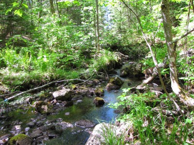
Wildcat Canyon

The rest of this day was very hilly and rocky. The trail went continually up and down steep hills with rough treadway, and we only made one mile an hour for the next four hours. Whew. But it was beautiful even so. This is Wildcat Canyon, a small rocky creek.
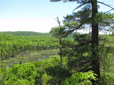
Dead River

A little later we were high on another bluff with this view of the Dead River upstream from where it feeds Silver Lake Basin. I'm trying to refrain from posting an overwhelming number of pictures. We also passed a lovely small pond and more big rocks than we could count... all of which make me ooh and aah.

waterfall in a rocky flume


Finally, at the very end of the day, we reached this rocky waterfall with no name. It sluices down a natural flume into a pool below. We treated water and soaked our feet because we knew that we would be camping in just another tenth of a mile. And we did just that in a nice meadow, having covered about 9 miles of difficult trail.