Entries to Win Afghan

Sign up to receive the Books Leaving Footprints Newsletter. Comes out occasionally. No spam. No list swapping. Just email me! jhyshark@gmail.com Previous gifts include a short story, a poem, and coupons. Add your name, and don't miss out!
Showing posts with label Hamlin Dam. Show all posts

Tuesday, December 22, 2020

Inspiration Point Loop

  Cathy and I went to Ludington State Park again today, but we needed to keep our hike short, as she has family Christmas things to do. We decided to go to Inspiraton Point and then see if we could get on the loop we found last week.

We parked at Hamlin Dam and walked across it. I took a short detour to get below it and take a picture. This small dam creates the huge Hamlin Lake! Hamlin Dam

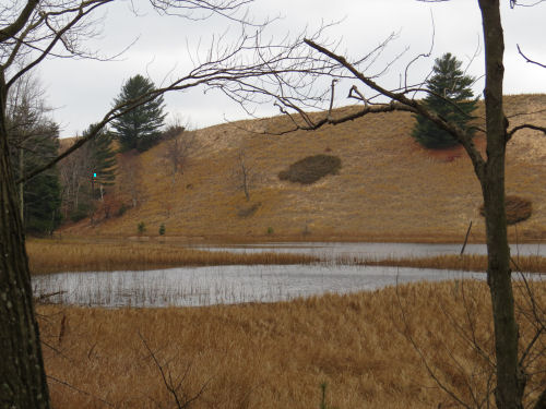
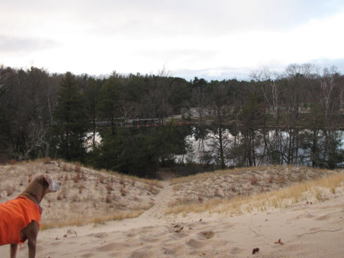
Once you cross the dam, you have to climb up a bare dune. This is the view up this arm of Hamlin Lake from about halfway up the dune. Hamlin Lake

Then you go down a dip, and up another sand ridge. At the top of that, you turn northeast on an unofficial trail. trail on a ridge

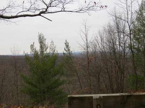
If you look down to the left, you'll see the foundations of the old CCC camp, where the men lived who built the stone shelters and did other work at the park in the 1930s. CCC camp foundations

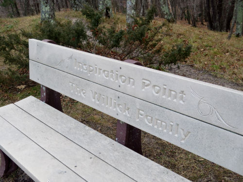
This trail takes you to Inspiration Point. You know you've arrived because there is a bench that is labeled. Inspiration Point bench

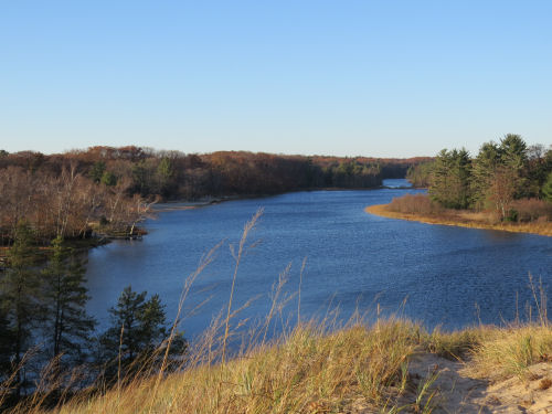
Here's the view across Hamlin Lake. Does it look familiar? It should because last week we were looking across at those same dunes, but from farther east and lower down. Hamlin Lake view from Inspiration Point

We figured this trail, which continued on, had to connect somehow with the loop we took last week. So we kept going. Somewhere, we turned south. This trail was not looking like the one we had been on at first. But after a while... we passed that same beech tree that is growing so low in the sand. So we knew we'd soon be back at the Y off the main trail by which we could return to the dam. Easy peasy.

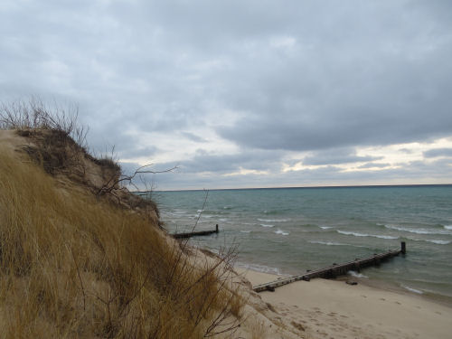
I had to stop on the way back for the obligatory picture of Lake Michigan. Notice the clouds. No conjunction viewing for west Michigan. Lake Michigan

We need to turn on an app to track where these trails are. We have no idea where we connected last week with the trail to Inspiration Point, but clearly we must have. We probably did 3.5 miles. A quickie, but better than nothing.

In other news: I did editing and grocery shopping. Bleah... but I hope I have everything for Christmas. It's going to involve more cooking than I want, but that will result in yummy food. So, there's that.

See Finding Inspiration Point
See An Adventure with Cathy

Tuesday, December 8, 2020

One Day, Two Hikes

  I had planned to walk with Cathy this afternoon, but then an informal group decided to hike at Big M ski area in the morning. Well, why not?

We hiked the highest, hilliest trail at Big M. This is the view north from Capper's Peak. view from Capper's Peak Big M

Let me pull that in for you a bit. I didn't look up what we are seeing, but my guess is the hills on the north side of the Manistee River. view from Capper's Peak Big M

Big M is an area within the Manistee National Forest, within the Udell Hills. The North Country Trail passes through it, but that's not what we were on. There are miles of cross-country ski trails. Of course these can be hiked when there is no snow. It used to also have a downhill run, and this is the foundation from the ski lift. Those hikers are looking south, so you can tell that Capper's Peak really is a high point. Big M

Oddly enough, there was an old travel trailer that had been dragged out into the woods. Loren reported it, because it's certainly not supposed to be there. old camper in woods

We did the Catamont Loop, plus spurs at each end to get from and to the parking lot. Catamont Trail sign

There were eight of us, and Loren's two dogs, who hiked. It's easy to spread out on a trail, and being outside is pretty safe anyway. hikers

Then I came home, got some lunch, and met Cathy to hike at Ludington State Park, the back trail out to Hamlin Dam. I didn't take many pictures, but this is a little pond that is on the inland side of one of the dunes. Technically, an interdunal wetland. pond with sand dunes

And our turn-around point- this familiar view of the back side of Hamlin Dam. Hamlin Dam

I've decided that I really like hiking when the temperature is in the 30s. If you hike right along it's easy to stay warm enough.

The really bad news is that someone in bell choir has tested positive for the virus. So my phone kept dinging with texts to tell us all that practice was cancelled. In fact... all the Christmas bell choir stuff may be cancelled. We'll have to wait and see. There is no other news except that I picked up some groceries on the way home.

My mileage for the day was a total of 8 miles- 5 at Big M, and 3 at the State Park.

Big M Ski Area, Manistee National Forest, Michigan. Catamont Loop plus spur from parking, and Double Bit and Lumberjack Trails to return to parking. Ludington State Park, Piney Ridge Road to Hamlin Dam and back

See Four Miles and Comfort Food for another hike to Hamlin Dam
See Hiking at Big M for another day I hiked the Catamont Loop

Thursday, September 6, 2018

Four Miles and Comfort Food

 
Did four miles with 33 pounds this afternoon. I was stiff after yesterday's fast walk, and thought I wasn't feeling much like doing this, but oddly enough, I put on the pack and everything felt good. We walked two miles on trail (not roads), sat down for a few minutes for a snack and drink and a visit. Walked the two miles back to the car, and Nothing hurt at all. This is really encouraging. There was topography and logs to step over. Really and truly... nothing hurts. Very good news.

Ludington State Park

This is a hike route I take occasionally, from Piney Ridge Road to Hamlin Dam.

It's one I like a lot because there usually aren't many people on it. Cathy really likes it too. In fact, she's the one who first told me it exists.

Ludington State Park

It leads to the back side of Hamlin Dam. You can just see the orange warning floats above the dam if you look beyond the greenery.

Ludington State Park Hamlin Dam

We managed a better selfie today.

hiking friends

And look what I found on the way home-- a puffball that is still edible. Not sure if it will be OK tomorrow, so I ate a double helping tonight. This is one of my ten favorite foods in the whole world. (not that I've made a list of ten, but if I did, it would be there)

frying puffball

In other news: I worked several hours at Shagway Arts Barn. Often, when I'm out there I can get some writing done, but I just couldn't get my head in story gear today, and then a man came in who wanted to talk forever anyway. So it was probably just as well I wasn't feeling annoyed that he was keeping me from writing. In the morning I made granola and filled Cathy's dehydrator. Need to deal with that yet tonight and refill it.

See Giant Puffball
See Another Walk with Cathy
if you like this blog, click the +1   or

Like This!


Sunday, November 13, 2016

Season of Thankfulness - Health

 
Today I'm specifically stating how thankful I am to be in good health. As many of my friends are having more and more difficulties, I'm still in pretty good shape.

This is partly due to good genetics, partly due to the fact that for the most part I like healthy foods better than processed stuff, partly due to enjoying exercise, and mostly due to the grace of God. I really am thankful.

I take no medications of any kind on a regular basis. The only real health issues I have are shoulders that dislocate very easily, and I can not have caffeine as it causes an irregular heartbeat. I think I can live with those.

To me, being able to go out for a hike is just about the best thing to do in the world, and I can still do so, pretty much without any restrictions. Today, I hiked the trail from Piney Ridge Road to Hamlin Dam.

This trail winds between the sand dunes and the south part of Hamlin Lake.

autumn trail

The late afternoon light and comfortable temperatures (mid 50s) sure made for a nice time.

autumn trail

The climb up to the top of the final dune follows a valley which was knee-deep in leaves! Not sure I've hiked in that many leaves before. It was kinda fun.

knee deep leaves

At the top (you've seen this hike before) is the back side of Hamlin Dam.

Hamlin Dam

And the view up the lake was gorgeous today.

Hamlin Lake

I need to be careful to never become complacent about appreciating my ability to visit places like this on foot.

See A New Trail To...
See Finding Inspiration Point
if you like this blog, click the +1   or

Like This!

Thursday, April 11, 2013

Big Sable River Walk in the Rain

 
I had a little time to kill after doing errands till I clocked in at work. I walked a mile-long loop at the Ludington State Park that goes on both sides of the Big Sable River. You've seen sections upstream and downstream in other posts. This was a very tame, paved walk, but it met my time requirement, and kept me out of the mud. With four days of rain we now have serious mud!

Here's the walkway.

Sable River walk

These pictures were taken with my phone. It's not bad, but doesn't seem to have the clarity of the camera. Plus... it was raining! This is the view downstream. Follow this for another 3/4 mile and you will come to the Big Sable outlet into Lake Michigan. On the far bank are some reddish trees. Those are Speckled Alder, like the ones I showed you last week.

Big Sable River

There are interpretive signs along the walkway. There used to be a small village known as Hamlin along this section. Thus, the names Hamlin Lake and Hamlin Dam. It was established in the 1850s when the first dam was built. The interpretive sign here explains that the river was much different then. It was narrow and fast, perfect to power a mill, which was why the dam was built, and the village grew up. There was a dam break and bad washout in 1888, from which the village partially recovered. However, in 1912 there was a full dam failure, and the village was completely wiped out. The river was also changed to become the wider, slower one seen here. The log pilings along the edge here were put in by the CCC in the 1930s to help prevent erosion.

Big Sable River

Here's the current Hamlin Dam. It was just rebuilt a few years ago (under controlled conditions which did not empty the lake). It's always amazed me what a small dam creates the huge lake. I've shown you lots of pictures of the lake, and it's the one I swam across in 2011. Here's a link to the Hamlin Lake Map. The dam is at point 3.

Hamlin Lake Dam

Even in the rain and wind there was something of beauty. The wind riffled the surface of the water, making sections of texture and lighter color. If I'd had more time I could have just watched that for quite a while.

Big Sable River

And at work, the lady who really knows how the machine works took time to show me the right way to set up runs. I like it that she seems to trust me, and she's going to be the boss tomorrow too (she's not usually there on Fridays), so I'll get to work with her even more.

if you like this blog, click the +1   or

Like This!


Saturday, December 17, 2011

Finding Inspiration Point

 
Today was the monthly Spirit of the Woods hike, and it was just us three girls again (Loren, Ellen and me!). We are having a great time every month, but if you are local, we won't mind a bit if you crash our party. Come join us in January (Pine Valley Pathway, Jan 21)!

three hikers

A couple of years ago, someone asked me if I'd been to Inspiration Point on Hamlin Lake. I said that I had not, but for some reason (maybe we got interrupted?) I never learned how to get there. Well, today, we found it by accident!

We began by hiking the trail that I told you about in A New Trail To..., but we started at the dam and went the other way. Coming back, we took a side trail high on a dune ridge along the south side of Hamlin Lake.

In about a half mile, we came to a bench with the label "Inspiration Point." Here's the view to the NNW.

Hamlin Lake

We sat on the bench and ate our lunches. But it was COLD, so we didn't sit there long. The ice is beginning to form on the edge of the lake, and I just liked the patterns it makes.

ice patterns

All together we hiked about five miles. We only had two dogs today. Loren only brought Corky, as Teak and Cedar are finding it harder to do the long hikes. This picture is closer to Lake Michigan, before we actually started walking, but I just like it.

hiker on dune

We saw a Pileated Woodpecker, and some gulls. Not a great wildlife day, but we sure had a good time. And now I know how to get to Inspiration Point!

And... I can explore another day, because the trail goes on farther. I wonder where it goes? You know I'll tell when I find out.


See Hamlin Lake Inspiration Point is just to the east of #3
if you like this blog, click the +1  

Wednesday, November 30, 2011

Hamlin Lake

... and arrived at Hamlin Lake Dam!

I'd been told that's where I would end up, but it was still awesome, because I'd never seen it from this side. Look sort of above Maggie along the far "shore" and you will see orange floats. Those are for safety, above the dam.

Hamlin Lake Dam

Now look the other way, up the lake. It looks narrow and smallish.

Hamlin Lake

But it's not. Everything you see in these pictures is in Ludington State Park. But the Lake is not small at all. This end, very near the dam, narrows down, but here's a map to give you perspective. Check out the mileage legend. The big blue space to the left is Lake Michigan, of course. The dam is located at number 3.

Hamlin Lake map

So, before we go any farther, let me show you the dam. Think about the size of this lake. It covers 4992 acres (surface area), and has a maximum depth of 78 feet. That's a pretty big lake. Now take a look at the dam.

Hamlin Lake dam

Too bad there was no one else there so I could put a person in for perspective. The dam is only about 8 feet tall, yet it creates that huge lake! Isn't water amazing? It was built during the logging era (about 1900) to create the lake for floating logs. The dammed river is the Big Sable.

OK... what are all those numbers on the map? I thought I'd show you where some of my other adventures have been.

Point 1: Big Sable Lighthouse- Two Lighthouses and a Trail

Points 2-3: Yesterday's hike- A New Trail to...", and A Day for Friends (the posed picture at the end was taken on the other side of Hamlin Dam)

Points 4-5: Where I swam across the lake in August- So Slow, But Undaunted

Point 6: Where the Big Sable River enters the lake. I don't have a picture from that exact location, but it's been featured upstream in Interesting Intersection but No Train and Cinq Rivieres

Point 7 (and surroundings): Nordhouse Dunes, where you've seen many adventures- Ellen and Joan Find Treasures at Nordhouse, or Ducks of the Day (on the little round lake to the right of the 7), or A Tale of Nor-Dunes

Point 8: Victory Park- Orange, location of the Orange Mist cooler in the woods

Point 9: The end of Larch Drive- Overheard on Hamlin Lake

That's plenty of info for one day, but I thought it would put some perspective on some of the adventures where I've dragged you along! Work day tomorrow- who knows what I'll find?

if you like this blog, click the +1