Today's work was more a tale of five rivers than small lakes. Why did I spell them in French? Sounds sophisticated? I ended with the Pere Marquette- named for a French explorer? To be mysterious? Yes.
First we have the Big Sable River. You won't see this view from the road. This is from a private back yard... not bad, eh? This is the river that empties into Lake Michigan at Ludington State Park. Oh, that's French too- "big sand." The view is downstream.

Next, I headed to the far NE corner of Lake County. I drove over 150 miles this afternoon visiting sites. I crossed to the north side of the Little Manistee River on Old M-63. "Manistee" is an Ojibway word that loosely translates to "Spirit of the Woods." That's why so many things/groups around here have that name (like my trail club).
Here's the downstream view of the Pine River from Raymond Road. This is only a little bit upstream of the hikes on Silver Creek Pathway where you've recently seen the Pine. Both the Pine and the Little Manistee flow into the (Big) Manistee River, which reaches Lake Michigan at the city of Manistee.

But, I'm still on the north side of the Little Manistee, and need to head south again. So I recrossed it on Birch Street at the village of Luther. This is the upstream view, and it's also upstream of the earlier picture by nine road miles- who know how many river miles that is- at least twice as many.

Then I scooted southward, and crossed the Baldwin River at Baldwin, which were named for the governor of Michigan in 1872. This river crossing is on M-37, and in just a short distance it flows into the Middle Branch of the Pere Marquette. You are looking downstream.

In just two road miles, you reach that Middle Branch of the Pere Marquette, still on M-37.

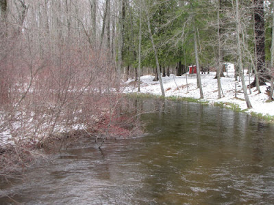
I had four sites to visit down there, and saw some little private lakes I'd never seen before. But by then I was seriously focused on rivers. But I still had to cross the Pere Marquette again to get home. I did that on Walhalla Road (you are looking upstream).

As you can see, by the time the river gets here, it's quite sizable, and the South Branch hasn't even joined it yet! This is the river that's a mile south of my house and reaches Lake Michigan at Ludington. There it widens into Pere Marquette Lake, where the carferries are docked, and then out a channel into the big lake.
Well, that's a lot of river pictures, I know it's probably overwhelming. There's a message in that. We DO have a lot of rivers here, and not every road has bridges. Getting around can be a challenge. Lots of roads keep the same name on both sides, but you have to know, or have a good map, which ones will actually take you across the water. More than once (not today) I've found myself at a dead end where a map showed a road going through, but... haha- joke was on me, and I got to backtrack. It's like a big puzzle!
OK, I'll stop now. I had fun tracking rivers today. Hope you did just a little bit.

8 comments:
Joan, what a treat, seeing all the river photos. It truly is a beautiful area in which you live and hike. Are all the rivers full of fish - good eating ones? Do you like fish? I don't ever see you talk about fishing so I wasn't sure. I enjoy fish - hate the bones ... and I don't fish.
I share your fun.
You bet those rivers are full of fish! Those are some sacred waters to fly fishers. Lots of Steelhead, Brown Trout and King Salmon.
After the native Grayling were decimated the Pere Marquette was the first stream in US to be planted with German Brown Trout. The Little Manistee playes an important role in the Great Lakes steelhead stocking program.
it's a healing sight, Sharkbytes, glad you find your way, it's sometimes stressful when you think you are lost or finding a way, but sometimes fun too :) like solving puzzle
A very enjoyable tour of the rivers. 150 miles huh? you did quite a bit of traveling today. At least it looks like you enjoyed yourself.
I love all of these river scenes. I guess rivers are something that we have in abundance all over Michigan. I'm surrounded by them here too, even though most are much smaller than those in your pictures. I love every one of them.
Carmen- Please notice a good answer about fish from Matt! I don't fish, mostly because I don't like fish to eat very much. A little is fine, but it's rarely my first choice.
rainfield- that would be an honor!
Matt- thanks for the fish answers! Nice to see you stopping by
Betchai- I like knowing how and where the rivers lie on the land. We've all but forgotten them with roads.
Ann- I did! This is a huge rural area I cover, but I like driving around on the back roads.
Ratty- Maybe there are a lot of rivers in Michigan. I've never really compared it to other states. NY has a lot more little creeks.
Nice river pix!
There is still some snow around! Will it ever end!?
Post a Comment