Today was interesting. After I did the paper route, I needed to stay in the town where that ends to do one of my work assignments. But I can't do those before 9 am. So I slept in the car for 3 hours. That's a good way to get a stiff neck, in case you didn't already know.
I did the last of my field work for the week, and got home at noon. Felt like crap. But today was predicted to be the lovely day of the week. So I decided to do an adventure that I've been wanting to do for a long time.
I followed a river. Since I only had the afternoon, I chose a short one. This is entirely within Mason County. The North Branch is shown in dark blue. That's the one I followed. I had no idea how far I could get in the time I had.

I really wanted to find the headwaters. But, where was it? The two lakes near the east end of the river, Ford and Round Lake have outlets that lead into the Lincoln River, as does a small lake called Picnic Lake. (SE of Ford) The source of a river is usually defined as the farthest distance upstream. So it may be Round Lake, but Cunningham Lake is higher (735 feet). At any rate, I went hunting for Cunningham Lake.
Shhh. It involved a bit of unauthorized access. But if you are the owner and you are reading this, I only took pictures. It was lovely!

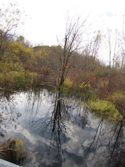
I couldn't get really close to the outlet, but it's about in the middle on the left. The creek was shallow, but surprisingly broad within about 50 feet of leaving the lake. It flowed through a swampy woods.

The circles on the map are where the pictures were taken. Once I followed the small creek to the nearest road, the rest of the day consisted of stopping at every place it goes under a road and taking pictures up and down stream. That's a lot of pictures, and not all are very memorable. However, I picked some to give you a sense of the river, and it's still too many!
Here's the Morse Road crossing- already the river is looking like more than a sleepy stream. I was quite surprised at how quickly it grew.
Where it flows north under Fountain Road it looks well adapted to the agricultural landscape, but then wild again where it goes south under Fountain Road just a couple of miles later.

See the splash? That is the straggler of three deer who were very alarmed at my invasion and crashing their way across the river.

These crossings were all culverts. However, at Darr Road, we finally get a real bridge. Although it's got weights limits. Also width limits!

Continuing west, here's the place where most people interact with the North Branch at US 31. It seemed more to the point to skip the water. Not that I like to, but this illustrates my pet peeve with bridges. They are safe, but you can't see the waterway. At least they posted the name of the river.

Well, let's skip ahead. Here we are on Victory Corners Road. This is the last place to picture the river before it connects with the South Branch of the Lincoln River (in teal on the map). Of course I'm wondering how much of it could be kayaked. Certainly not above Darr Road. Maybe below there with care. And a saw.

By the time I got there it had started to rain, and began crash-banging just as I got home! Good timing!
Well, perhaps you'll see the South Branch, or the Main Branch, or a different river, another day. Not this week. The price I pay for this fun is that I have to do all my reporting tomorrow. But, it's supposed to rain, so I think I made a good plan.
Now I have to try to go to sleep. 3 am comes early.
Oh, and dry feet are highly over-rated.
 | See Ducks of the Day |
| if you like this blog, click the +1 | |
4 comments:
That must have been a fun adventure.
Well you had a great day!
Chuck & Vanilla- I love following features that the surveyors and civil engineers have abandoned for those straight paved (or at least graded) things.
I'll take your word for it on the stiff neck and just not try sleeping in the car...lol
You had a nice little adventure today
Post a Comment