
Matt took all our tracks from the three sources: Avenza, OnX, and an Apple Watch and imported them into the software that NCTA uses to generate the Avenza maps. This shows about 0.2 mile of trail. The orange line is the Avenza track that Bill took. The line of fat purple dots is from Bill's Apple watch. The thin purple line in between is what I took with OnX. Now... the current line on the NCT Avenza maps is the red dotted line way off to the right. This is the kind of thing our data is going to be able to correct. The light green dashed line is where Matt chose to average the data from our three tracks. (I'm not sure what the darker green dashed line is.) Note that speech to text put in "punching" for "puncheon." But we know what it means.

Here's an example where our three tracks were in close proximity. And yet, the spacing between the two outside lines is about 20 feet. This happens because of many possible reasons. The apps need to communicate with four satellites to collet a point. The different apps may not choose the same four satellites. The apps may collect a point after a certain time interval, or after a certain distance which can affect accuracty. And, although civilians are allowed to have access to quite accurate data now, these low cost apps don't have the capability to get super accurate. Thus, the value of having multiple tracks. You can see where Matt is placing the "official" line (light green). He's pretty much going up the middle, but if two tracks are close together he gives them more weight.

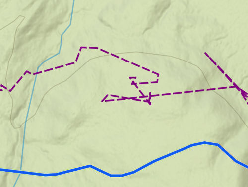
Here's another reason to have three tracks. Every once in a while one of our devices would seem to go haywire. This shows my purple track way off the trail and acting berserk (I was not over there wandering around). Each device took a turn or two doing this. We really don't know why. But it still left two tracks to average.
We got 87 miles of trail in the NCTA software today. That is a huge number for a single day. Matt still has some additional work to do, but he's hopeful these miles will be in the fall update.
The structure inventory data got sorted a little better, and we have a plan for what to do with it next.
Long day. 3 hours driving, 8.5 hours sitting at the picnic table. So very worth it, but I'm going to go get off my butt now.
 | See What We Did in the Adirondacks |
3 comments:
How interesting this is. I never realized how much was involved in creating these.
Lulu: "Wow, that's fascinating! What a lot of work! We can only imagine how hard this was BEFORE the satellites and the GPS ..."
Ann- it's a lot of work. I don't think a lot of people appreciate what Matt does.
Lulu- most trails on maps were not super accurate before GPS.
Post a Comment