Entries to Win Afghan

Sign up to receive the Books Leaving Footprints Newsletter. Comes out occasionally. No spam. No list swapping. Just email me! jhyshark@gmail.com Previous gifts include a short story, a poem, and coupons. Add your name, and don't miss out!

Sunday, September 30, 2018

Day Fourteen - Midland to Mackinac

 
Today was awesome! I made eight miles of forward progress. I am loving the wild and remote feel of this area. Miles and miles of evergreens and aspen always with a low ridge in sight in the distance. That said, the woods is full of guys in trucks and Jeeps and on ATVs scouting out places to hunt. I find it a bit hilarious how often I'm getting passed by vehicles on these nothing roads.

northeast Michigan backcountry

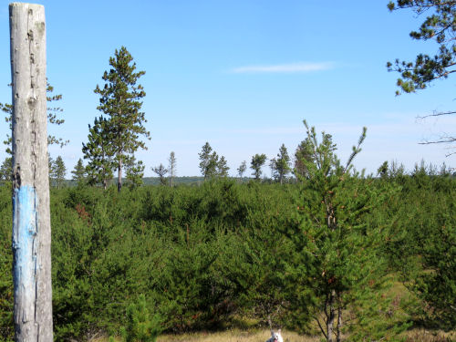
I particularly liked this little stretch on the "Wannabuk" Trail. For one thing, the footing was solid. In the picture above the M2M followed a snowmobile route that is all churned up sand. Who knew I should have trained for this hike by walking the beaches?

northeast Michigan backcountry

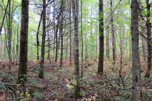
But the trail turned off Wannabuk in that band of jackpine you can see above. It took me an hour to do the next mile and a half. It was back to bushwhacking with blazes, and then a stretch where I would never have found my way except there was a bit of a treadway to follow. Crossed some mucky areas that could be bad in spring, and a small creek that is part of the headwaters of the West Branch of Big Creek. Little log bridge. I ate lunch there with the water gurgling.

log bridge

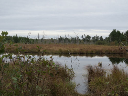
Then a large beaver pond where there would be some nice camping spots.

beaver pond

It was a good day for tracks. That soft sand took prints very well. I'm getting up in the area where the Michigan Elk Herd is located. Pretty sure I saw elk tracks both yesterday and today.

elk tracks

Most of the usual suspects: deer, raccoon, fox (of course it could have been a dog, but there were no accompanying human tracks), and maybe a bobcat. Kicking myself for not taking pictures of that. Sandhill crane, not too unusual, but fun.

sandhill crane tracks

The weather was perfect for hiking. I think it got a little warmer than they predicted, but about 50 degrees all day. My little thermometer broke just before this trip so I've had to guess. So I decided to try to get in a pile of miles. Pretty sure I got in 8 trail miles. But I had no particular interest in going back through that difficult stretch or repeating the 5 miles is soft sand, so I decided to walk other roads back. What a great choice!

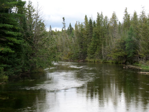
There is an area along the Middle Branch of Big Creek that I thought was beaver flooding, but I later learned it was dammed to create a long skinny lake. Made that walk quite enjoyable.

I saw a pair of trumpeter swans.

trumpeter swans

And then I watched an eagle swoop down and catch a fish.

bald eagle

Trail miles total: 109- over half by any estimation. Miles walked today: about 14.

Today's trail angel is named Clayton. I still had 3.5 miles to go to the car. I had it in me to do them, but didn't like how late that got me back, because I had a motel reservation waiting (the shower felt great and now the wet tent is drying over the rod). A guy in a Jeep stopped and asked if I was walking for fun or wanted a ride. I said I'd gotten my trail miles in for the day and would be glad of a ride. Turns out Clayton is a member of the outdoor club where Luke "Strider" Jordon spoke this past week about his Great Plains Trail hike! Small world, right?

Weather looking bad tomorrow afternoon. I think I'll do a short hike in the morning, and then come back and go to the laudromat and hardware store.

Did I mention how still it was today? Many, many times I could hear no human sounds at all. No breeze. Just quiet!

See Day Thirteen
if you like this blog, click the +1   or

Like This!

Saturday, September 29, 2018

Day Thirteen - Midland to Mackinac

 
Last night’s sunset wasn’t a very good predictor. Neither was the weatherman. It rained off and on all night again, and was cold this morning. Cold and drizzly. Nothing that kept me from hiking, but certainly not the pleasant morning I expected. That’s what I get for checking the weather!

p”ink sunset

Today was also all on “roads” of some kind or other. Paved, dirt, service roads for power lines, snowmobile trails. One real hill to go up and down. 160 feet elevation change on Elk Hill. I realize on an absolute scale that’s not much, but it’s the biggest hill so far on this hike. It went down again to East Branch Big Creek.

East Branch Big Creek

I reached my destination, but I can’t say I didn’t lose the trail. Again the M2M was concurrent with the Shore to Shore horse trail. They got all the markings, and I had no idea when the two trails separated. Checked each corner carefully, but when the S2S made a sharp east I said, “nope.” Followed the power line out to Townline and then walked west to where my trail came out to that road.

No one there was going to find their way easily. I dragged the sign to where it at least should be if it were upright.

fallen signboard

Let’s talk about trail marking. So far, I’ve been mostly following the blue blazes. Some have been dark blue blazes. Every once in a while there is a DNR trapezoid with the Scout emblem that is just for this trail. Sometimes there is the hiker/skier trapezoid. The S2S trail has it’s own trapezoid with a horseshoe. Sometimes there is flagging tape. Blue is reassuring, but someone went through a lot of miles with yellow tape, and that has been helpful. But here’s one I hadn’t seen yet. Just a hiker. Hiker faded. Hiker down.

hiker trapezoid

And while we’re on blazes, let’s talk about why I have trouble finding them so often. You’d think I’d have no trouble seeing this, right? Ones like this are great. Quite freshly painted, and they sort of stand out in the woods like Christmas lights. Easy to spot.

bright blue trail blaze

The paint does fade. This one is probably about five years old. Not bad. It was put on a tree that hasn’t shed it’s bark badly. Really good blazers scrape the loose bark before painting, which makes the blazes last even longer. This one also is still pretty much a rectangle. Although, on this trail, blazers aren’t so careful about that either. Harder to see from distance, but acceptable.

faded blue trail blaze

Sadly, all too often, this is what I’m finding, however. It’s probably been ten years since this blaze was touched up.

faded blue trail blaze

And this one.

faded blue trail blaze

Finding these spots on the trees when there is no treadway to follow at all is what has made some of the days really difficult, and slow. Today, however, all went great because I found all the trail going one direction or the other. I'm not trying to be super critical. There just aren't enough people caring for this trail. But it will need better marking and more treadway to get good use.

It warmed up a little bit after two o’clock and there was intermittent sunshine.

cloudy sky

But except for needing to keep adjusting the jackets to stay warm enough without being too hot, it was a fine day.

Forward progress on the trail about 6 miles. Total trail miles to date: 101! Not quite halfway, but over a hundred. (Of course, this is all just best guesstimation. No one has actually measured this trail on the ground.) Total miles walked today 12 or maybe 12.5

See Day Twelve
if you like this blog, click the +1   or

Like This!


Friday, September 28, 2018

Day Twelve - Midland to Mackinac

 
Everything is starting to feel more autumnal. It rained all night, and continued into the morning. I sat in the car and watched turkey wander through the campsite nibbling whatever it is they nibble. Then a black squirrel did the same. I took pictures, but they look like you’d expect through a wet car window.

I needed to find an adapter plug and learned there was a hardware store only 7 miles away. Off I went on that mission, and discovered a nice restaurant right across the street. I ordered a hot sandwich. It was excellent. Half was enough to fill me up then, so I saved the rest. (Ate it just now) But I ate all the homemade potato chips then.

Back at the campsite, and it looked as if the worst of the rain was over, so I started walking at 12:20. 95% of what I hiked today was on roads of some description, and I’m happy to say that I never once lost the trail. (Not too difficult, right?) However, I did have to guess which way to go at a fork, but I guessed correctly. There was one blaze in that half-mile and I blew it a kiss as I passed it.

red autumn leaves

After leaving Rainbow Bend Campground, the trail joined Conners Dam Rd, a two-track. This was a lovely two miles.

Just when you think summer is over and the delicate flowers are gone, harebell, Campanula rotundiflolia will surprise you.

harebell

I actually didn’t go off route to check out the lake until on the way back, but Conners Lake is easy to access. Loved the lonely shore.

Conners Lake

Here it is from the dam.

Conners Lake

Then I did four more miles on paved road before I turned around. Crossed the North Branch of the AuSable. I don’t mind taking pictures of rivers from bridges. People in cars hardly notice when they cross. But the waterways are often beautiful.

AuSable River

On the way back, the tree that looked as if it had a few red leaves was fully visible. Wow!

Red Tree

Saw two more birds worth noting- an eagle and a bluebird. (And maybe a kingfisher, although it was too far away to be sure it wasn’t a bluejay).

Pretty good for a day that started out looking like it might be a bust. I’m no longer alone at the campsite. Well, it is the weekend! But I do have to drive somewhere to get enough bars for internet access. Found a place closeby that works!

Forward progress on the trail about 6.5 miles for a total of 95 miles. Total miles walked today- 13. I’m a little footsore from the pavement, but nothing serious. The adventure continues.

Tomorrow is supposed to be the one guaranteed nice day for a while, so I hope to do some good miles.

See Day Eleven
if you like this blog, click the +1   or

Like This!


Thursday, September 27, 2018

Day Eleven - Midland to Mackinac

 
Almost! I almost had a day with no bushwhacking. Actually, depending on how you count it, maybe none. I lost the blazes 3 times, but each time found them within 5 minutes again.

Had a wonderful trail angel this morning, Cindy Faust, whom I hadn't ever met, but she agreed to spot my car. I decided to go for more miles, and got in 13! She and Bridgee met me and took me to where I turned around yesterday. Thanks, Cindy!

hikers and dog

They walked with me for 40 minutes before turning around.

hikers and dog

I've never spent much time in the upper east part of lower Michigan. It has a very desolate feel to it, very much like the UP.

spruce and hills

dead tree

The trail joins the Shore to Shore horse trail for a couple of miles. The good news is that you won't lose the treadway, but it's not great walking for humans. I wasn't sorry when they parted ways.

trail signs

Quite a few rolling hills today. I loved the pattern in this fallen log.

patterns in wood

And some pileated woodpecker was feeling very linear when it did this.

tree with woodpecker holes

Love the name of this road, and it also meant I was getting close to the end for the day.

Linger Longer Road

Crossed the AuSable River, another milestone.

AuSable River

Total miles today 13- both miles walked and miles that count. Total miles this trip 88.5.

Gotta scoot. I'm parked at a road corner where I have cell service to post this. Need to get back to campsite before dark.


See Day Ten
if you like this blog, click the +1   or

Like This!


Wednesday, September 26, 2018

Day Ten - Midland to Mackinac

 
You are going to start thinking that when I lose the blazes, I don't look very hard because I just enjoy bushwhacking so much that I want to do it yet again.

I hiked for exactly 20 minutes with blazes and lost them at the beaver flooding of East Creek. I was particularly dismayed, because even if I could get across the creek I could potentially have to bushwhack for two miles to hit a road.

Northward I went via compass (no sun). Actually managed to cross the creek on a beaver dam. See the humpy thing heading out into the water on the right? That. The picture is actually looking back south. I forgot to take a pic on the other side.

beaver dam

The bushwhacking wasn't too difficult, but of course, one never knows what is ahead. That's the stressful part when alone. I really have to make it back to my car. Preferably on the same day.

open woods

Found this really interesting fungus. It might be Hen of the Woods, but I'm not positive.

fungus

Bushwhacked for 35 minutes and came upon a two-track going north. Took it! Five paces later... blue blaze!!!!

two track with blue blaze

This blaze was astonished to see me again. "You never give up, do you?" it said.

blue blaze with eyes

Just before one o'clock I reached a major milestone. This actually makes me feel as if I'm getting somewhere. I left State Forests and entered the Huron National Forest.

Huron National Forest sign

Wow! The next two-plus miles of trail I can actually recommend. There was interesting terrain (one little puddle of hills there), there was established treadway, there were consistent and correct blazes. I would actually call those miles pleasant!

Got to my destination and ate lunch. It doesn't look like tomorrow's trail is as good. Sigh. I guess someone just loves those two miles.

I decided to walk back on Meridian Road. I should have checked to make sure you could get through on it before I started hiking. The maps look like it goes through, but I know from my experience yesterday that there is at least one piece of it missing. But I figured I'd go as far as I could before cutting back to the trail. What I didn't really want to do was try to bushwhack back through that same section with the creek because of the uncertainty of finding a place to cross East Creek. Kind of unlikely I'd find the same beaver dam.

Anyway, I'm walking along and although, unlike Lucy, I did know where I was, this felt Narnian. There are almost no road signs at the corners of these sand roads. And yet... here I am... Meridian and County Line.

Meridian and County Line Road sign

Meridian continued for another mile. So far so good. A hunter in his truck was coming up Meridian. I stopped him and asked if the road goes through. He said it did. I showed him on the map where my car was. He said, "I saw it. A little Subaru, right?"

So now, I was feeling happy. Just 2.5 miles to the car and no more bushwhacking required for the day. Crossed East Creek on the road. It's really very pretty. I especially liked these hummocks of grass with water shield around them.

hummocks of grass in wetland

Progress on the trail for the day, about 5.5 miles. Total for the trip 75.5 miles. Total miles walked today, about 12.

Got new pants at the thrift store this morning, so I have more confidence that I will return in the afternoon fully clothed. Also, I wore the Gumby II jacket until mid-afternoon. The day was damp and chilly, and the jacket was great.

See Day Nine
if you like this blog, click the +1   or

Like This!