Daniel White
b. August 19, 1649 Marshfield, MA d. May 6, 1724 Marshfield, MA
Oldest child of Peregrine and Sarah (Basset) White.
Married Hannah Hunt on August 19, 1674.
Children: John, Cornelius, Benjamin, Ebenezer
Buried in Cedar Grove Cemetery, Marshfield, MA.
Very little is known about Daniel. The family property was deeded to him in 1674 by his father, Peregrine. He would have been 25 years of age.
Peregrine had a large house and quite a lot of land. There was the original gift from Sarah’s father of 40 acres, but he was also granted land because of being an original settler. 100 acres were gained by that grant in 1673, but there may have been more at another time. Also, Peregrine purchased additional land.
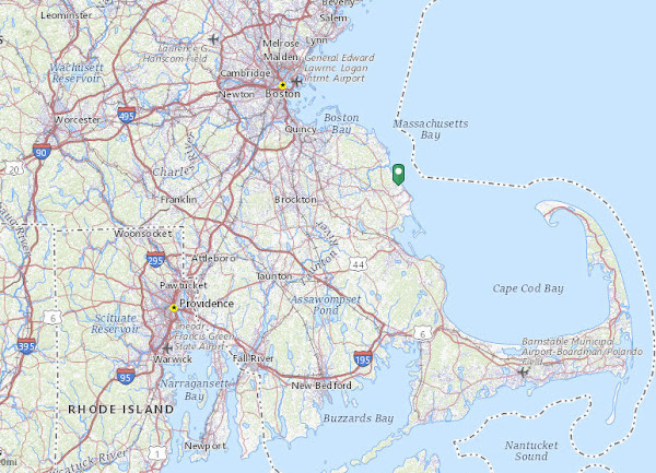
So, Daniel suddenly became the owner and probably primary caretaker of a lot of property. We do know exactly where this land was. Marshfield Town (township), Massachusetts is on the coast of Cape Cod Bay, north of Duxbury.
The North and South Rivers met and flowed into Massachusetts Bay. The White property was at the base of Snake Hill just southwest of this river mouth. Since that time, the mouth has been relocated. Currently, Rexhame Beach is now found where the old rivermouth was.
This is a current map from Google Terrain of that area. You can see the T in the river, just west of Rexhame Beach. That was the original outlet from the North and South Rivers.
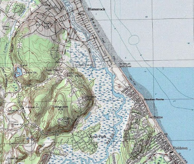
This is the USGS Topo map of that area. You can see Snake Hill is named, as is the old river mouth. The name of the road that encircles the hill is now named Peregrine White Drive.
Snake Hill is important, because Peregrine’s and thus Daniel’s property was just at the southeast base of it. It’s indicated as being marshland, but apparently it wasn’t too wet to build on. Additionally, the marsh grass that grew there was considered a valuable resource for feeding the cattle that were brought to the colony. Documentation of the first cattle in New England is lost, but there was known to be a population of them in 1627. Cattle had been brought to the St. Lawrence River area in the mid-1500s, and to New Netherlands in 1625. Peregrine’s will states that he had, in 1704, one ox, half interest in a horse, four cows, one heifer, and half interest in three young cattle, along with some other farm animals. But these listed certainly would have eaten the marsh hay. Perhaps the half interests were with Daniel.
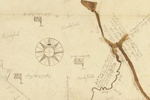
On this map, from 1795, the North and South Rivers show, and what appears to be the Episcopal church somewhere on Snake Hill.
This 1838 map shows the same area, and the names S. White and J. White indicate that the land was still in the White family. It also shows the location of the Peregrine White apple tree.
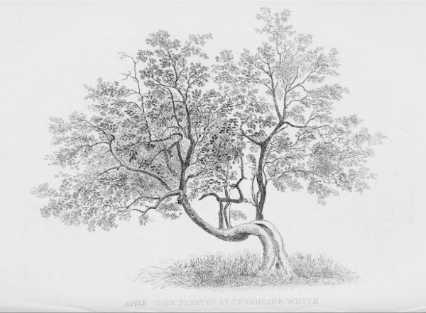
This tree was undoubtedly planted while Daniel was a boy. He certainly helped tend the animals and harvest the fruit from this tree while growing up in the house pictured in the Peregrine White entry. This is a drawing of the tree in 1854. Half of the tree had died by 1851, and the remainder was dead by 1914.
However, a piece of wood from the tree was presented to the Hanover Historical Society in 1865. This is a real connection! I could touch something that was also touched by Daniel.
Daniel’s will survives, but I have not yet been able to access it on line. Perhaps it will verify that he continued life as a farmer.
Interestingly, Find-a-grave has a lot of wrong information about some of the next generations. This appears to be due to confusion concerning which Hannah Daniel married.
In other news: I edited and wrote.
 | See Peregrine White |


2 comments:
Lulu: "So much interesting history! Our Dada likes old maps. We have an old map of Oceanside hanging up in the hallway, in fact, but it's not nearly as old as those two!"
Lulu- I stole those maps from the internet. One can order actual reproductions, but I think I have enough stuff. The digital ones will be fine.
Post a Comment