Entries to Win Afghan

Sign up to receive the Books Leaving Footprints Newsletter. Comes out occasionally. No spam. No list swapping. Just email me! jhyshark@gmail.com Previous gifts include a short story, a poem, and coupons. Add your name, and don't miss out!
Showing posts sorted by relevance for query straight line wind. Sort by date Show all posts

Friday, June 11, 2021

That Valley Trail

  I'm taking you back to one part of Tuesday's hike at the State Park that I want to tell you more about. I thought I had pictures that showed how this has changed, and I do!

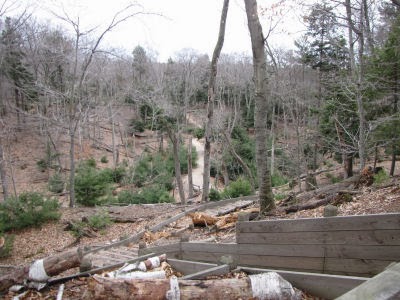
When we headed back toward Lost Lake we cut across a valley on what is now part of the Lighthouse Trail. But long ago, this was called the Beechwood Trail. That was before 1998. That year, there was a large, straight-line wind event called a derecho. To have that designation, there have to be sustained winds of more than 58 mph. The result was that almost all the trees in that valley were flattened. In 2010, you could still see the effects of that with tree trunks littering the ground in a linear way. The trees felled were mostly maple and beech. valley with trees blown down

The trail was closed for years. But the park redesigned the trail system, and in 2010, this was the valley, now with a set of stairs leading down to the floor, where you can see some regrowth of white pine lining the edges of the trail. This is now a portion of the Lighthouse Trail trail with stairs into a valley

Well, I took a picture at pretty much the same location on Tuesday. Look at the valley now! You can't even tell it had been bare. Nature is amazing. trail with stairs into a valley

In other news: Another hot, hot day. I did finish mowing the lawn before sundown last night, and tried to do some outside tasks this morning, but things didn't go right, so not much was accomplished. I did one load of laundry. After that I tried hard to make it a book day. I managed to write a whole chapter, and worked hard on the cover. Stay tuned. This evening, I attended another of the Reading Regatta Zoom events.

See Two Lighthouses and a Trail
See Straight Line Wind

Wednesday, August 10, 2022

The 2007 Ham Lake Fire - Day 253

  I did succeed in resting most of the time today. I only did a little bit of cleaning and sorting, and laundry, in between reading chapters of the book I bought at Gunflint Lodge. It's called Gunflint Burning by Cary J. Griffith. He is an author I already was familiar with, and I'm very interested in the Ham Lake Fire. I really couldn't put it down.
book Gunflint Burning


A lot of you already know quite a bit about fires and the Boundary Waters. I'm sure some readers don't, so I'll try to give a brief overview and explain my interest.

The story begins with the July 4, 1999 infamous blowdown. A derecho (straight line wind) blew in excess of 90 mph for 1300 miles from North Dakota to Maine. Of the million or so acres in the Boundary Waters Canoe Area Wilderness, over a third were affected. An estimated 25 million trees were blown down.

First reports said "the Kek will never be opened," but of course volunteers got busy, and it was. Then the corridor was improved. The pictures I have from the 2003 Volunteer Vacation I took there show some of the devestation, but those aren't digital, and I don't have them with me. The best I can do is show a picture from last week. You can see the cut ends of tress that are high off the ground. Trees were piled like pick-up sticks. New trees were not yet tall enough to camouflage it as in this picture.
fallen trees

On the Volunteer Vacation I was on, our duties were to clear out more fallen trees (some participants were chain saw certified). Most of us spent the week clipping baby alder trees and berry bushes. With the sudden sunlight after the blowdown, the growth of such shrubbery was phenomenal. We had a crew of 7 people, and we cleared about 6 miles near the center of the Kekakabic trail in five days. (It took us a full day to canoe in, and another full day to canoe out.)

So, the trail was opened, but then the question became, "When will it burn?" There was never any doubt that it would.

Several fires are notable, Alpine Lake, Cavity Lake (2006), and the East Zone Complex Fires all occurred before 2007.

Here is a map of the Cavity Lake Fire (tan), and the Ham Lake Fire (brown). I've drawn a very rough blue line for the NCT across this map, so you can see how the trail was affected.
Boundary Waters fire map

So after the 2003 trip, and a few years of spinning my wheels, I got serious about planning my hike through this area. I created an itinerary in 2006. Then the Cavity Lake Fire happened. I created an itinerary again in 2007. Ham Lake Fire. I followed this fire quite closely at the time, reading news reports every day. Although that fire was in the spring, the Kek remained closed. Again in 2008, I planned a hike for August. The trail was closed due to the danger of fire. I finally smartened up, and planned a hike for the spring of 2009. That time we were successful.

However, the scars of the Ham Lake Fire were still very raw. The next two pictures are in the section on the east side of Gunflint Lake- visible in the first picture. We saw this area first, because we were hiking east to west, but this was actually the last area burned by the Ham Lake Fire.
burned wilderness
burned wilderness

After we passed through that, we were on the south side of Gunflint Lake. The lake is about 7 miles long and less than a mile wide. Gunflint Lodge, Heston's Lodge, and many others are located on the south shore of the lake. However, the fire burned right down to the water on the Canadian side, which you can see in this picture from the Gunflint Lodge dock. Previous owners told me they stood and watched the fire come down the hills, hoping it would not jump the lake. (I know that distance sounds like a fantasy fear, but the Ham Lake Fire was pushed by such strong winds that it was forever "spotting," starting fires far ahead of its front.)
Canada across Gunflint Lake

On the west side of Gunflint Lake, the fire started at Ham Lake, just slightly south of the trail line. Winds first blew it west and northwest. There was hope that it would burn into the Cavity Lake Fire area, run out of fuel and stop. Look at the map again. But, of course, the winds changed. The fire blew north into Canada, then the wind changed again, and it blew down to the southeast, to the north shore of Gunflint Lake and around the east end as seen in the pictures above.

Here are two picture from 2009 where the trail had burned across the Kek.
burned wilderness
burned wilderness

Now, these burned areas are covered with 20-foot tall aspen. There is only an occasional charred trunk or stump visible. Except for the stands of younger trees, I could not even tell when we passed through this area last week.

The Ham Lake Fire was one of the largest in Minnesota's history. It was eventually elevated to a Type I Fire- the most serious- because of the people and resources needed to fight it, and because it crossed the international border.

How did it start? Most wildfires are actually started by lightning. This one was the accidental result of a careless campfire, built by an experienced camper. If this doesn't scare you into being extremely careful with fires, I don't know what will. There was not a ban on fires that week, although perhaps there should have been. The conditions were hot, dry, and windy. You can say he should have known better. You can say a lot of things, but this story always makes me a little queasy. Things like this can happen to any of us.

And some of you probably know how the story ended. Because it happened on federal land, he was charged with federal crimes, even though he had not intended to start a forest fire. Unable to deal with the possible consequences, he committed suicide before the case went to trial. His death was the only human casualty of the fire.

The book is excellent, and puts some perspective on the story- better than following news reports. Also, I have met several of the people who are part of the story. I suppose I can't say I know them well enough to call them friends, but enough to really personalize the whole drama.

See Today's Object of Joy

Sunday, December 12, 2010

Snow and Old Wind

 
snow covered tree

For some goofy reason, we didn't get as much snow as the rest of the state. I did run the snowblower early this morning- wet heavy snow, so it's not blowing as much as a dry snow would. Most schools are already closed for tomorrow, and I sense another snowblower run in my future!

Now for the Old Wind. Some of you may remember that I have talked about a big wind storm in 1998 a few times. It was classed as a derecho wind event, which is straight-line winds with sustained force higher than 58 mph. I previously showed you the valley at Ludington State Park that was leveled, and how it is growing back. That view, at Two Lighthouses and a Trail, is in summer, looking south in the valley.

snow covered tree
I learned yesterday, that with the old logs highlighted by snow, you can still see the linear pattern of how the trees all blew down. This is the same valley, but looking north. My breath was taken away when I first saw how the trees were all knocked down there, after that storm. Here's another view.

snow covered tree
That is the same storm that snapped my big basswood tree. But the summers come and work their green magic, and eventually the memories won't show even in the winter.


Thursday, May 7, 2009

About the Kekekabic Trail


Kekekabic Trail map thumbnail

I am going to use our travel days to tell you about the trails we will be hiking. Today is the Kekekabic Trail (KEK), Say KEK-kuh-kah'-bik. The map above is clickable to make it larger.

One piece of the KEK can be traced back to the 1880's, as a wagon road to the Paulson Mines, but was primarily a road for fire management, built in the 1930s. It's hard to believe that it ever was a road though... it's very primitive. It was soon abandoned for that use as airplanes took over fire spotting. In the 1960s it was converted to a hiking trail, and was popular in the 70s. However the Forest Service stopped maintaining it and it nearly disappeared until the Kekekabic Trail Club was formed in 1990. Now volunteers attempt to keep it open.

That is a real challenge. In 1999 a huge straight line wind blowdown occurred. First people said the trail would never re-open. Then they said it would take 5 years to re-open it. Two years later, the KEK was ready for hiking again, but the fire danger was intense. Also, all the ground that hadn't seen sunlight for decades was springing up with brambles and young birch. Keeping the trail clear enough for anyone to find it became a real problem.

In 2007, the Ham Lake Fire burned across several miles of the trail. We are expecting to encounter a number of difficulties on this rugged trail.

See The Blog Plan for the Arrowhead Hike
See Kekekabic Trail Club
See North Country Trail Association

Saturday, February 21, 2009

Crows Take a Hike


My mother was a great one for quoting silly little rhymes. One of her winter standards was:
The snow the snow, the beautiful snow
It freezes above and falls below.
The bluebird, the blackbird, the robin and crow
All stick their feet in the beautiful snow.
Today there were no birds at all venturing out to stick their feet in the snow. They were all sensibly hunkered down wherever they could find shelter from the wind and snow. The snow was from the east, which is very odd, and blowing. The skiing was great, but I wasn't stopping to take any pictures. But Maggie and I went out twice.

However, I've been working on a collection of pictures to show because on the days when the weather is nicer I've been amazed at the amount of walking around that the crows do. I mean, they aren't like turkeys that have a lot of trouble getting off the ground... And yet, they hike all over the field, walking for yards and yards of distance. I hadn't really noticed it before, but this past week when there has only been a dusting of snow (until today!), I could follow their walking tracks for 50-100 feet!

This set of 3 strips shows crow tracks in light snow, medium, and deep snow. You can see how much the conditions change how the tracks look. You get nice definition of the pads and claws in the light snow, and just broken holes in the deep snow.


I made the next picture big so you can see how this crow was just walking along in a straight line. You can see one of my boot prints too. The picture below that is just kind of funny. There are tracks going both directions, and some places the crow broke through the crust and in some places it didn't. If you look closely at the bottom of the picture, one foot is going one direction and one the other direction. I think that crow was hopping around for some reason. Maybe he was doing a dance!


P.S. February 26 will be a milestone day for me. I'm planning a special post for Thursday.

Friday, March 19, 2010

Two Lighthouses and a Trail


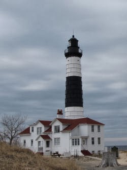
Big Sable LighthouseSince today was the last warm and dry day we are supposed to have for a while, I just had to go for a good hike. I decided to do the Lighthouse Trail at the Ludington State Park.

It's not my favorite trail. It's very cold in the spring and fall because of the wind, and very hot in the summer as you cross open dunes. The loose sand is hard to walk in. Nevertheless, Maggie and I had a great time, and I updated this trail section on Get Off The Couch. It runs from the Big Sable Lighthouse, east and then southeast across the park to end at the Lost Lake Trail on Hamlin Lake. Then you have to take other trails to get back to your car. Of course the lighthouse is very nice.

deer

gray squirrel

We saw a few critters too! Just some whitetail deer and a gray squirrel, but it was nice to know that the wildlife is moving around in the nice weather. (OK, I also saw gulls, geese, and a pair of swans.)

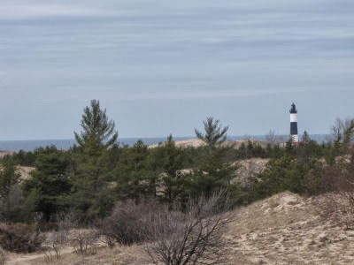
dunes

This view comes after you climb over some of the dunes on the trail and look back to the west. It's very typical of the open areas in the park.

valley regrowing with pines

This picture has a long story. Prior to May 1998 the valley you can see here was filled with full-grown trees. We had a storm with devastating straight-line winds. Every tree in that valley was flattened. It looked like Mount St. Helens without the ash. As a result, the trail through it was closed for years. Only two years later the white pines you can see down there had started to grow. A few years after that the park put in the steps which now lead down to the valley floor, cleared a lot of trees and hardened that section of trail. It must have been a huge job! But now you can walk that way again.

Ludington Lighthouse

Finally, on the way home, I stopped at "First Curve" and got a decent picture of the Ludington Lighthouse. You wouldn't think that this is so difficult, but the light on the lake, or choppy water, or haze often make it really hard to get enough contrast for the small light to show up well. I like this shot a lot!

Hope you enjoyed the hike!


See Ludington Beach in January
See What Maggie Saw

Thursday, August 29, 2019

My Trailer Redo - Day 93 - Waiting for Water, and a Wall

 
I thought I was only going to be able to say that I spent the day waiting for water, but one wall happened!

This is what the afternoon looked like. The skies got darker and darker and the wind was blowing pretty well, but I kept working until the sky started playing with electricity. Then I decided it was time to put away the power tools.

stormy sky

Before that happened, however, I clamped the beadboard paneling to the plywood and cut them out together. I want the two partial walls I'm putting in to be sturdy, as part of the internal support system. I decided they didn't need to be 3/4 inch ply, but I want them solid.

laying out a custom wall section for a fiberglass trailer

Then I glued the two pieces together, just as the storm was starting. My hobby clamps were large enough to go around the edges of this, and it's a good thing. It needed some persuasion to stay together evenly. And I had forgotten how much I hate the smell of fresh-cut masonite.

As I was cutting this, I was having second thoughts about my wall covering choice. Given how totally, totally un-true everything is, suddenly a wall board with vertical lines seemed like a bad decision. I chose to make the longest straight edge line up with one of the grooves in the pattern.

I also thought maybe it was going to chip like crazy when I cut it. I tried a scrap first, with masking tape on the finished side and clamped to a piece of scrap wood. I cut a wavy line in that (scroll blade on the sabre saw), and it was fine. So that was a relief.

But I ended up taking the glued and clamped wall into the house because it started pouring. The wait for the water from the sky was over.

gluing layers of a custom wall section for a fiberglass trailer

Went out and sat in the trailer while it was raining. Still weeping under the old air conditioner hole, but I got the leak to move. I'm not too worried about this. I'll keep adding to the outside fill every time I do a batch of fiberglass, and I'll get this one stopped.

leak a fiberglass trailer

What I was hoping for was to find the source of another leak. When I moved the table the other day, I discovered another puddle in the center back. I watched diligently, but not the slightest bit of moisture came down the back wall. Well, Marie and I will probably have some chances to chase it down on this trip.

I also did some non-trailer odds and ends, and ate dinner, and the sky cleared up and the sun came out. I REALLY wanted to get more done today, so I went back out. The wall pieces seemed to be holding together fine, even though they hadn't been together anything like eight hours. But I was feeling impatient.

So I screwed that wall in place. It will have to come back out again when I put the flooring back in, but that's OK. This will give me a chance to have a test run with it to see if it's working out. I tacked the front uprights of that bench to the floor, and put on the bench tops, tacking in place the one that doesn't need to provide any access. That nicely holds things more rigid. The others are loose for now.

That side of the trailer is ready to go! It's pretty cool to have one tiny bit of the final finish wall in place. (No trim yet, of course.) And it looks fine! The vertical line along that front edge is where it needed to be no matter what is actually vertical (although that pretty much is).

 custom wall section and bench for a fiberglass trailer

I decided to do a little bit on the other side. Worked on that back bench brace. Of course, it's not the same as the door side, so I had to just do it in two pieces. It's ready for fiberglass.

And I made the extension for the bench upright for that side. It's ready for corner braces.

That "wall" is just the old bench stuck in there upright to give me a sense of what the wall will look like. I have it marked out on the plywood sheet, but things were too wet on the porch to try to cut it out this evening. But I'm in good shape to continue tomorrow. I checked that back brace with a level, but it sure doesn't eyeball right. (Not that little nubbin- that's just balanced there.) Will check again before I add fiberglass.

bracing for a bench section in a fiberglass trailer

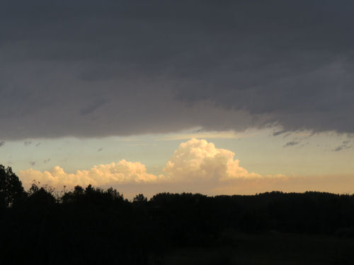
Here's what the sky looks like now!

sunlit shelf cloud
"
I really want to get this second bench and wall done so I can move on to some temporary refinements. Marie and I are going to live in this for almost 3 weeks, and I can easily jury rig some pieces of the storage so that things won't be such a mess inside, with nowhere to put things. If I get the benches and these two walls in place, then I'll have time to fool around with the little things that will make our "home" more pleasant.

But now, I'm really ready to settle down. I didn't get to sleep till after 3 am last night because I was just so wound up about the trailer. Could not stop planning all kinds of things in my head. Solved a couple of small issues, I think, so that's good at least.

See Bracing and a Bench
if you like this blog, click

Like This!


Monday, January 10, 2022

Little Miami Railroad - Day 41

  From Yellow Springs (yesterday), all the way to Milford, I'll be on the Little Miami Scenic Trail. This is a rail-trail, the former bed of the Little Miami Railroad.

Like most any railroad, it's pretty straight and flat. That said, when the portion from Milford was surveyed toward Lebanon and Waynesville in the 1840s, the grade of just under 1% was too steep for the locomotives of the era. So the rails were laid to Morrow, Fort Ancient, and Oregonia to Waynesville. These are now the familiar place names along the North Country Trail. Although eventually merged into Conrail, the road operated until 1981. Little Miami Scenic Trail

Here is the through-truss bridge across the Little Miami River railroad bridge over the Little Miami River

And a highly typical Fleming Through Girder Bridge over Gladys Creek. (the wood rail on the inside is for the trail.) railroad bridge over Gladys Creek

The Little Miami RR was only the second railroad built in Ohio. The first was far to the north, the Erie & Kalamazoo. Most people in Ohio were satisfied with canal travel. Railroads were seen as a means to connect towns that weren't on canals. But onstruction of the LMRR began in 1837 because water routes were not available in winter months when they froze.

I guess we can assume it had reached Spring Valley by 1844, since this mill is oriented to the rail line. Spring Valley woolen mill

You can almost always find where a rail line went through a town by looking for businesses oriented off the orthoganal street grid. Street on the right, rail grade on the left. This building is also in Spring Valley although I don't know what it used to be. Spring Valley building

The line was extended to Xenia by 1845. Here is the beautiful Xenia station. Xenia Station Xenia Station

And this building, just south of Yellow Springs, has been identified for me as the Miami Powder Mill, maker of gunpowder. It was located at a small settlement called Goes Station. It has been closed since 1925, but clearly the building is being maintained. I couldn't detect that it had a siding, but the building was very close to, and oriented to the tracks. interesting brick building

Today was cold. As soon as the temperature rose a little bit a biting wind came along as well. I hiked fast! I was warm, but I didn't take long breaks.

Miles today: 17.1. Total miles so far: 602.2 OVER 600!

BONUS SECTION: Just fun.

Nancy brought pasties that were made in Marquette, MI. Who eats pasties in Ohio? We do! pasties

And this is for my duck-loving friend, Diana. duck doll

See Yellow Springs