Today, I went out to do a couple of assignments with my job as a Field Data Collector. The road I drove was one that I've traveled many, many times in the past. But I'm trying to pay more attention to even familiar places. While double checking the topo maps, just to be sure that I knew what I was talking about, I learned that there used to be tiny settlement called Sauble. Actually, that is great info, because it gave me a way to tie these two pictures together, other than the fact that they are taken from the same road, Hamilton Road.

This view is looking south. The hills in the distance are called Ward Hills. That might sound vaguely familiar, because it's a place that I like to hike. The hills are only a little bump, as hills go, but there used to be a small, family-friendly ski area there with just a rope tow. It's long gone. I never went there, and really don't even know exactly where it was.
At the bottom of the valley between me and Ward Hills, is the Big Sauble (usually spelled Big Sable) River, and the corner that is all that's left of the hamlet of Sauble.

Here's the Big Sable River approaching Hamilton Road from the east. Farther east, the North Country Trail crosses it on the Vince Smith Bridge.
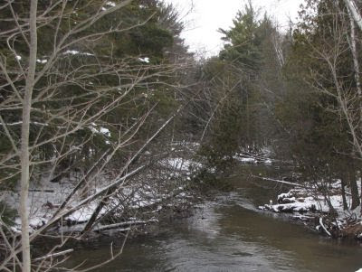
And here's the Big Sable River heading west toward Lake Michigan. The Big Sable doesn't get as much press as most of our other rivers, because it's not really navigable, even by canoe or kayak.
Where it reaches Lake Michigan (20 miles away in a straight line), at Ludington State Park, it is dammed to form Hamlin Lake, and then reaches the big Lake in a wide, shallow swath that is one of the premier locations to watch migrating waterfowl in West Michigan. You can see Hamlin Lake behind us at A Day for Friends, or in On Lost Lake, a part of Hamlin Lake
This was fun for me... to try to explain to you how a little piece of what I saw fits into the local landscape. I hope you enjoyed it too.
 | See Walking at Ward Hills |
7 comments:
I could easily settle into walking the areas - just like home, I love rivers.
I followed you, all the way.
and it was fun for me to get to see a little of that landscape. Looks just like the kind of place I would enjoy exploring
It's soooo pretty! I saw lots of concrete, traffic, and potholes today--not quite so lovely. Sigh.
I'm aware of the Aux Saubles River, in Ontario, Canada, which flows into Lake Huron. I think it means "the river of sand." So I assume your river must have a sandy area somewhere.
Carol- I have been wondering if one could "walk" the river in summer. A lot of not public land on the banks, but if not too overgrown one could try what I call "stream stompin'"
rainfield- if we were to meet we could take turns
Ann- where I took the pic from is private (except for the roads), but almost all of Ward Hills is public, in the Manistee National Forest.
Lin- Ugh... I don't envy you living in the burbs.
Ferd- HAHAHAHAHAHAHAHAhahahahahaaaaaaa. Oh, let me see if I can stop laughing. A LITTLE sand? That's all we have is sand. All those hills are stabilized dunes. Lower Michigan is one big sandbox.
I wonder if there's any sign of the settlement hidden away? I guess wooden buildings wouldn't survive, but maybe something has?
Post a Comment