We had a big group today with 16 hikers. The weather was drop-dead perfect. Not too hot, not too cold, low humidity, sun.

You know I was happy to have my littlest hiking buddy, Sophie, nearby.

This is a pretty neat section with some variety in the things you see. At first the trail is high above the Manistee River. I took some pictures, but they don't look like much. The light just wasn't right to show what little of the far bluff you could see very well.
One really interesting feature is a narrow glacial moraine. The trail follows right along the ridge. (Picture by Sue- Sophie's human)

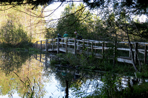
Here's a bridge the chapter built just a few years ago. This is an area that the beavers insist on reconstructing fairly often. So what used to be a small 10-foot bridge has now become this. You can see that the edge of their dam is almost under the bridge and the water level in their pond is pretty much even with the ends of the bridge. Hope they don't feel the need to make their dam higher!

This is right at the bottom of the bluff where the trail comes down nearly to river level. This open grassy area is known as Leitch Bayou. It's quite different from other places on our trail.

We saw some kayakers and fisher-folk on the river here. It's a nice calm section and very picturesque.

After about a mile the trail climbs back up into the forest. The leaves haven't really turned at all yet. A few occasional colors here and there.

This section is hillier than some, but we had everyone back to their cars by dark. That makes me feel like I did my job.
I hiked part of this last fall. See Hike 100 Done. And near the beginning of this section is where I got to participate in the archaeology dig. See Archaeologist for a Day
North Country Trail, Highbridge north to Upper River Road TH, 10.9 miles
 | See MNF Hike #11 |
| if you like this blog, click the +1 | |
1 comment:
A perfect day for a hike. Nice turn out.
Post a Comment