Entries to Win Afghan

Sign up to receive the Books Leaving Footprints Newsletter. Comes out occasionally. No spam. No list swapping. Just email me! jhyshark@gmail.com Previous gifts include a short story, a poem, and coupons. Add your name, and don't miss out!

Saturday, June 14, 2014

Third Hiking Day- May 25- Alder Lake to Beaverkill Rd

 
This day was totally trail miles. The sun greeted us, slanting through the trees, as we crawled out of the tent. We had been sprinkled on a little bit, but since the past two years we've hiked in frigid, all-day rain, we were thrilled with this year's weather.

sun through trees

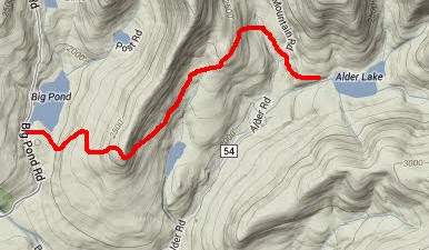
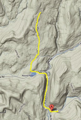
We had left a car at the day's destination, the end of Beaverkill Road, the night before. This gave us the chance to make an earlier start on the trail. We only had to drive a few miles to Alder Lake. There are the remains of a mansion on the site, but no information about who lived there. When we hiked past, several campers were bunked on the lower stone walls!

mansion ruins

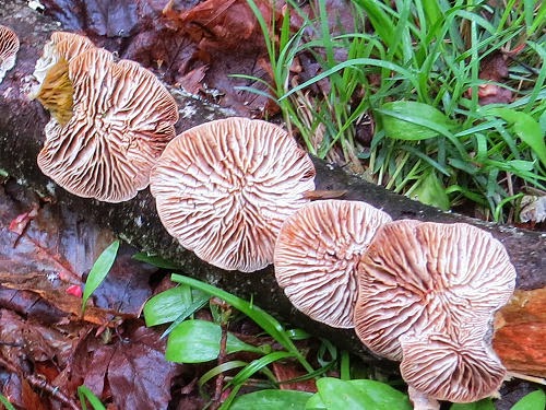
There's nothing like a level walk through a beautiful blue and green landscape to help even morning-bumbly me to wake up and "smell the roses."

Alder Lake

Some ups and downs, but the big goal for the day was to reach the top of Balsam Mountain. It was a presence as we approached it for most of the day

Balsam Mountain

Those slopes look so smooth from a distance, but the trail is rugged and rocky- a hallmark of the FLT in many places.

Balsam Mountain

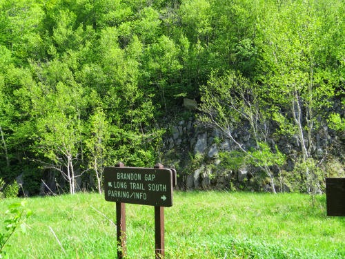
We passed this marker and knew we were getting close.

3500 feet

Actually, we didn't go all the way to the summit. That's an additional 60 feet higher off the Finger Lakes Trail at the fire tower. The trail reaches its high point on this mountain, however, at 3660 feet. We passed that point without even a marker. However, when the trail started down, we had no difficulty figuring out that we'd done it. The downhill was nearly vertical and brutal to knees. We met a lot of people walking up to the firetower as a day hike, since the parking lot (and our car) was just 1.5 miles away.

Catskill map

Mileage for the day- 8.4

See Second Hiking Day
if you like this blog, click the +1   or

Like This!

Friday, June 13, 2014

Second Hiking Day- May 24- Alder Lake and Wildmeadow Rd


Let's be honest. Marie was not the only one who wasn't excited about backpacking after that first, tough day. I was really shocked at how tired I was, and my insides weren't back to normal (still aren't, but that's another story, with less quality). So we decided to figure out a way to do all of the remaining Finger Lakes Trail as day hikes. It took a lot of driving, and some creative rearranging- not hiking contiguous pieces, but we did it.

So on this day, first we hiked three little miles from Big Pond over to Alder Lake at the next road. These were trail miles.

Catskill map

You can practically count on seeing old stone foundations on eastern hikes. We always love to speculate about who lived here and what kind of people they were. You can deduce more than you might think from a pile of stones.

stone foundation

These shelf fungus were on a broken branch that was flipped over to show the undersides.

fungus

Then we moved the cars- it took a lot of time- few roads, all narrow with lots of curves, but the routes were beautiful too. See how the hills just swallow the roads? (that's mist rising from the hill, not smoke)

Catskill road

We added 6.5 miles of the road walk to this day, which took us down Wild Meadow Road and then into Claryville.

Catskill map

Sometimes you get the nicest views of the hills from the road walks because there aren't so many trees in the way. I always love the hills.

Catskills

And, guess what? There's always that little blue bedroom at the end of the day! Dry, snug, and ready to shelter us for a nice rest.

tent

See First Hiking Day- May 23
if you like this blog, click the +1   or

Like This!

Thursday, June 12, 2014

First Hiking Day- May 23- Berry Brook Rd to Big Pond

 
Here we go! I'm going to try to take you through our hikes day by day. I'm actually swamped and breaking back into real life slowly. Very slowly (grump, grump).

We met the first night and planned to set up the tent and start camping. However, it was pouring with thunder and lightning. We opted for motel camping! It was nice, although expensive. It was also dry.

Aspen Motel

When we headed for the trail... well. It was a challenge. There were three 800-foot climbs and another 200-footer, just for fun. All within 9.6 miles. That's when I learned that my stamina certainly wasn't back to the proper level yet. We went over Mary Smith Hill, Middle Mountain, Beech Hill, and Cabot Mountain. I just like the way the rock curves along the edge of the trail here. This piece of trail wasn't too steep, but most of these climbs were pretty rocky and vertical.

Mary Smith Hill

The next two pictures are sights that are welcome, comfortable friends of the northeast spring woods. Wild Columbine and the red eft.

wild columbine

red eft

There were some really nice vistas to reward us for the climbs. A little hazy, but not bad.

Catskill vista

We hiked right into the place where we were camping at Big Pond. Because it was the holiday weekend there were park rangers checking on things. One of them asked us where we'd walked from. When we told him, his eyes got big and he said, "That's a pretty good hike." So even though we were really pooped, that made us feel a whole lot better. The truth is, this turned out to be the most difficult of any of our hiking days. We must have been getting in better shape as we went along, but there were no other days with so many steep and rocky places.

It was strikingly reminiscent of a day at the western end of the Finger Lakes Trail, many years ago, when we also hiked over three similar hills all in one day. I only remember the name of one of them, Jimmerson Hill. It has remained a symbolic nemesis of all wall-like obstacles that must be overcome, ever since.

We pitched our "little blue bedroom" at Big Pond, ate a cold dinner rather than drive somewhere, and crawled in our sleeping bags.

Here's a map of day one: The maps aren't going to be the same scale each day, but you can get the idea. Red line is trail hiking (not road).

Catskill map


See I'm Thinking About May for the overview map
if you like this blog, click the +1   or

Like This!

Thursday, June 5, 2014

We Hiked!

 
Today, we are back at Marie's house, where I will get to spend just three more days with her. I'd rather it be about three more weeks, or months, or years. I hope each one of you has at least one friend who is as close as the two of us are.

We were playing our favorite word game, and Marie was dealt this hand! I am not making this up.

Quiddler hand

Two big completions in the past couple of weeks. First, I finished the Finger Lakes Trail, making me officially End-to-Ender #370. All I have to do is send in my record form and I'll receive that patch.

Then we drove over to Vermont and hiked the 65 additional miles that are being added to the North Country Trail so that it will connect with the Appalachian Trail. Luke (Strider) Jordan hiked this piece last year, but Marie and I are numbers 2 & 3 to do so.

I can't get organized quite enough yet to start taking you through the days of the hikes, but here are some more feel-good teasers. When we were last at Crown Point, in 1996, the old bridge, built in 1929, was the link to Vermont.

Crown Point Bridge

Now, there is a new bridge, opened just last year, and you can see it here in the same perspective. This is where we began the Vermont piece. Technically, I guess we were still in New York until we were halfway across the bridge! It has pedestrian walkways, and is a beautiful crossing of Lake Champlain. Lots of history there. More on that another day.

Crown Point Bridge

Any day is a good day that we are hiking together. Total miles this trip- about 112. I have to add up the corrected mileages, but this isn't off by much.

hikers

if you like this blog, click the +1   or

Like This!

Sunday, June 1, 2014

First Day on Long Trail


Hoping for a fast blog post before WiFi Cafe closes.

This will be fast! What a trip! We are tired but having a wonderful time.

Walked 9.9 miles today from Middlebury Gap to Brandon Gap on the Long Trail in Vermont.

Brandon Gap sign Long Trail

We had moose tracks- and not the ice cream (not to mention great masses of moose poop.)

moose track

Lots of rocks! Here I am coming down Gillespie Mountain.

descending Gillespie Mt

I put a picture of a great vista on Facebook, too. Gotta scoot, but wanted to check in.


if you like this blog, click the +1   or

Like This!