Entries to Win Afghan

Sign up to receive the Books Leaving Footprints Newsletter. Comes out occasionally. No spam. No list swapping. Just email me! jhyshark@gmail.com Previous gifts include a short story, a poem, and coupons. Add your name, and don't miss out!
Showing posts with label Letchworth. Show all posts

Saturday, September 11, 2021

Letchworth 3 - the Gorge

  Today was the best day of this hike, and we completed the Letchworth Branch. The trail was mostly well maintained with fewer deep dips to creeks. The temperature was drop-dead perfect, and after a brief mosquito-y start, they even gave up. photo label

But, as everywhere here, the creeks are all lined with shale. This is a good example.
rocky gully


The very best though, is that the trail gives a number of views of this portion of the gorge of the Genesee River. This is sometimes called the Grand Canyon of the East, but that name is also applied to a deep gorge in Pennsylvania. No matter what you call it, it's impressive. Genesee River Gorge

This is a closeup of that bump in the rock wall. Genesee River Gorge
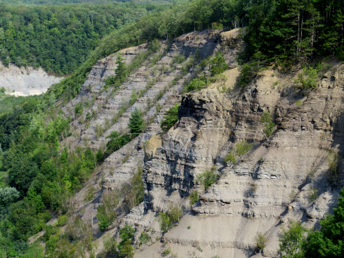
And here is a view looking upstream instead of down. Genesee River Gorge

Just to give you a sense of this valley, here is a longer view of the floodplain. You can barely see the river down there. Genesee River Gorge

And what is the point of this? Here we are at the Mount Morris Dam. This dam is 215 feet tall, and was finished in 1951. The purpose is flood control. Downstream from this location is the city of Rochester, which regularly suffered catastropic floods prior to this date. Unless there are serious storms, the water is just allowed to flow through the dam. There is no reservoir. However, in storms, the water is held behind the dam and then released gradually to prevent the damaging floods. Twice, the water has risen to within four feet of the spillway at the top of the dam. Now glance back at the floodplain picture. And keep in mind that this valley is 17 miles long. Think about how much water was being held behind that dam! Mount Morris Dam

And this is the thing my dad loved about this park. He liked to go and look at the dam. I think he had experienced one of the Rochester floods, and he understood what a big deal this is.

We have now finished the Letchworth Branch of the FLT.

Letchworth Branch of the Finger Lakes Trail. 9.4 miles, approximately Ridge Road to the northern terminus in Mt. Morris

See Nice Trail

Thursday, September 9, 2021

Letchworth 1 - Yellow Blazes

  We are now following yellow blazes. We are doing another of the Finger Lakes Trail branches. This is the Letchworth Branch which goes the length of that park and along the gorge cut by the Genesee River. I've been here a lot of times in my life. It was one of my dad's favorite parks- he didn't have many, but I'm not sure we'll even see the thing he liked the most. And I've hiked here with Irene several times since I've been blogging. yellow painted blaze on tree

I've previously hiked pieces of this trail with Irene, but I'm not sure I'd done the parts we hiked today which was the southern end of the park. Letchworth Trail sign

The weather is delightfully cool, however it decided to rain for an hour in the middle of the day. We managed to hit a park pavilion at the right time to eat lunch and stay dry for most of that time, but I did have to put the camera away. This is at the Parade Grounds, a flat open area where a number of divisions of troops mustered for the Civil War. lunch in a park pavilion

This is just a roadside weed, an agrimony I think, doing it's first year rosette (whatever it is, it's a biennial), and I think it is pretty. Newish, and very invasive weed, Narrowleaf Bittercress, Cardamine impatiens. rosette of basal leaves

The best of the day was taking a spur trail after the sun came back out that followed the edge of the Letchworth Gorge. The rock walls are about 200 feet high. Letchworth Gorge

Here's another view. See the green water at the bottom?
Letchworth Gorge


And our destination on that spur was the view of the Middle Falls. The Upper Falls is just visible above that. You can see the Letchworth Bridge spanning the gorge at the top of this picture. This is a new bridge, built in 2017, which replaced an iron bridge that had been in use since 1875. This is an active railroad bridge, operated by Norfolk Southern. The new bridge has been named the Genesee Arch Bridge.
Letchworth Gorge Middle Falls and Genesee Arch Bridge


It was an easy hiking day. A lot of the trail was on a former railbed, and was quite level.

Letchworth Branch of the Finger Lakes Trail, southern terminus to Dygert Rd with spurs, 8.7 miles

See Letchworth Hogback