Entries to Win Afghan

Sign up to receive the Books Leaving Footprints Newsletter. Comes out occasionally. No spam. No list swapping. Just email me! jhyshark@gmail.com Previous gifts include a short story, a poem, and coupons. Add your name, and don't miss out!

Friday, June 20, 2014

NCT Vermont Extension- TAM to Middlebury Gap

 
Last road walk of this outing! We had miles to do on route 125, from where the Trail Around Middlebury crosses that route to what's known as Middlebury Gap where the Long Trail crosses that same route. We had a great incentive to finish this walk in record time. There were signs all over Middlebury advertising a Rhubarb Festival. Well, we both love rhubarb! It was 10-2 at the Universalist Unitarian Church. So, we wanted to be back in town by 1 pm. We started hiking at 8:08.

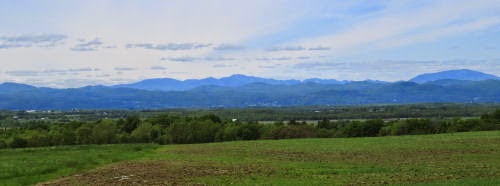
The road quickly rises as soon as it turns east, and provides great views.

mountain view

When one is not zooming by at 50 mph or more, one can find beautiful things to see along the road. Here's a wild azalea in bloom.

wild azalea

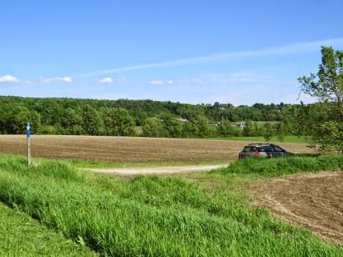
One of our concerns was whether we would actually be able to walk this route. Yes, on the road. There was a bridge over the Middlebury River under construction and cars had to follow a long detour. So, the day before, we had driven past the barriers to the actual bridge to ask if we could walk through. No one was there, but clearly the bridge was in place and walkable. Imagine our surprise when we arrived on foot the next day and discovered it was also open to traffic! But the cars mostly hadn't discovered that yet, so traffic was low on the whole section that was previously closed. We like that.

East Middlebury bridge

East of East Middlebury there were serious cuts through the rocks, and each face was moist and covered with exquisite moss and fern gardens. I'll take one of those for my back yard, please. The picture doesn't even begin to do them justice.

ferns on rocks
The road follows right along beside the river. Steep plunges were followed by flatter spaces. We liked these red rock strata. They were unlike most of the other rocks we saw.

red rocks

Almost at the top here. This is the Bread Loaf School of English- a graduate college of Middlebury College. It was founded in 1915, and is known for Robert Frost's association with it. The core of buildings are older than the school, built by Joseph Battell, beginning in 1861, as a summer resort. Battell was a local publisher and author who bought up vast tracts of land which eventually ended up mostly as the Green Mountain National Forest. The classic buildings were awesome. It would be very cool to return there for some sort of writing course, sometime.

Bread Loaf School of English

Here's a baneberry in bloom. Is it red? Actaea rubra, or white? Actaea alba. I didn't know there was a way to tell them apart before the berries appear, but there is! Red baneberry has slimmer, greener stalks, and small hairs. I think this is red. Now that I know this, I'll have to practice with the info.

red baneberry

Occasional breaks in the rocks, near the top of the gap, provide more glimpses of the Green Mountains- looking blue and misty in the morning.

Green Mountains

Did we make it to the Rhubarb Festival? We finished hiking at 12:46. And now I'll tell you our dirty little secret. Did we hike this in the west-east direction of travel we'd been doing? Heck no, we had cars and we aren't completely stupid. We walked downhill, east to west.

But there's more to the rhubarb adventure. No one in town that we asked seemed to know anything about it, or even where that church was. Finally, a lady in a bookstore looked it up on line. "Oh yes," she said. "I think they have a new building." She directed us on foot, but it was now well after 1 pm, and we'd already walked 12.2 miles. We hopped in a car and drove there, squeaking into the event just before they stopped serving lunch.

We hadn't really known what to expect (but were hoping for pie). What we found was a large rummage sale, a plant sale, games for kids, and lunch for $5, or maybe six. Very reasonable. We paid our fee and got in line. Did I take one single picture? Nope. We were hungry and forgot. But there was turkey or tofu with rhubarb chutney; the salad had roasted rhubarb as a garnish, and the dessert was rhubarb bread pudding. It was all very yummy.

We each bought a few used books. Neither one of us can resist cheap books. I think I got 5 books for $2.75, and two of them were ones I'd been specifically looking for- an almost unheard of success story. After that we went back to our tent and visited and read. We like to read out loud to each other, and I usually bring something about the local history, or some adventure. That didn't happen for this trip, but we simply enjoyed a couple of mysteries, and chilled.

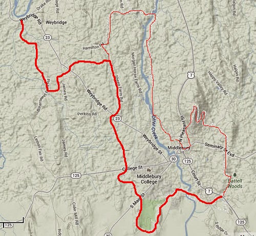
Here's today's map. Tomorrow... onto the Long Trail.

NCT Vermont map

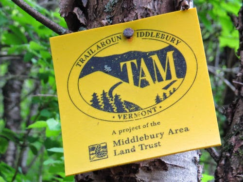
See Trail Around Middlebury
if you like this blog, click the +1   or

Like This!

Thursday, June 19, 2014

NCT Vermont Extension- Trail Around Middlebury (TAM)

 
For our second day of hiking in Vermont, we planned 9.6 miles, all of it on the western portion of a loop trail that encircles the city of Middlebury. We briefly met with the man who has been the driving force for this effort for 20 years, John Derrick. He had provided me with maps and info ahead of time. Despite the bad storm they'd had, and extensive clean-up work he said he had to do on his farm, he was out mowing the trail, too. Trails never happen without passionate, dedicated people who work hard to create and maintain them. We had hoped to take him to dinner, but he said his wife told him he was already committed to something else that night.

John Derrick

So, we headed off along the edges of some good-sized farm fields. It was quite reminiscent of portions of the Finger Lakes Trail... except for those Green Mountains still ahead of us in the distance.

Trail Around Middlebury

Our blazes for most of the day were the TAM logo. It's a silhouette of mountains and hills, with some evergreens, and the letters T-A-M in the base of the mountain. But... um... don't tell John, but we decided that from a distance they look like a cow facing left. So, we just followed the cows.

Trail Around Middlebury

One of the best sights of the day was a bobolink singing for us on a shrub. I haven't seen many since childhood, and I hope they are making a comeback.

bobolink

Much of the piece in the middle of the day that was pretty much straight south was in the woods. That was a beautiful walk along the base of a ridge where we could look out to our right into sunny wetlands along a creek. Then we entered Middlebury College property, and the trail wove in and out of woods and meadows, and finally (didn't) go through the college solar array. We did take a wrong turn here and got to see the panels up close, and also got to walk at least an extra half mile to get back to the correct place. Who would want to walk under 10 miles for the day, right?

solar array

We saw very few real cows on the hillsides, even though it's dairy country. John told us that most cows are "kept on concrete," because there isn't enough land to both graze them and raise feed for the winter. He said his own small herd does get to go outside. It seems sad to me that some cows don't get to be outside at all.

cows

After following a ski trail around a golf course, and getting rained on a little, near the end of the day we crossed Otter Creek on the Boathouse Bridge. It's a sizable suspension bridge, and John said he built it. I think this means he planned, organized, raised funds, and also worked on construction. I'm sure he had help!

Boathouse suspension bridge

Here's the map for the day. The eastern half of the loop is the very thin red line. We chose the west side for a rather stupid reason- it was the side John highlighted when he sent me the map. So I thought the NCT had decided to follow that side. I guess either option is fine. The east side is more "urban," (we were told), but also has some nice woods and nature preserves. I wish we'd had time to do that side too, just for comparison.

TAM map

Sections like this are part of the reason I love the North Country Trail. I love the wild and high spots, but I also love the patchwork of experiences that can be found working one's way through the landscape, whatever it is. You'll never get tired of the "same old thing" on the NCT.

See Crown Pt Bridge to TAM
if you like this blog, click the +1   or

Like This!

Wednesday, June 18, 2014

NCT Vermont Extension- Crown Pt Bridge to Trail Around Middlebury

 
My excitement level was really high as we drove to the Crown Point Bridge on Thursday, May 29. I hadn't yet seen the new bridge, just opened in 2011. This is a truly strategic, historic location on Lake Champlain, and we'll come back here after the hike- there's lots to show you. But for today, it's "just" the place where we'll begin hiking east.

Crown Point Bridge

Officially, the North Country Trail still ends/begins at this bridge in New York. But, hopefully, a bill is being introduced in Congress this year that will add this Vermont extension to connect the trail with the Appalachian Trail. The new bridge has pedestrian walkways on each side. Here we go.

Vermont sign

Once over the bridge we turned south, and had many chances to shoot lovely views of graceful span.

Crown Point bridge

We had remained flexible in how to divide the hiking days up. There was a possibility of some trail over Snake Mountain, but our contact in Middlebury said they'd just had a bad storm and portions were seriously washed out, and it wasn't marked. So we chose the road walk around the base of the mountain. Here's the north end of the snake- we're actually headed for the south end, but this was the visible slope that we could keep in sight. That distinctive scarp was easy to keep track of.

Snake Mountain

Along the way we had a nice view of an osprey. It had a nest on a platform, but seemed pretty fond of the chimney cover on this house.

osprey

Finally, we got close enough to Snake Mountain that it was just a presence, not a distinguishable shape.

Snake Mountain

One of the strangest things, to me, was that this day was on a fairly level area between the Green Mountains (our destination), and the Adirondacks (some of my favorites). The Daks were a shock, every time I looked west where there was a break in the trees. This is one of the nicest views. I don't have much sense of the peaks from this angle, but I'm pretty sure the big hump in the back right is Giant which I have not climbed. I don't think you can even see Mt. Marcy (the highest peak) from this perspective because it's farther west. One of the peaks right near the middle is Dix, which Marie, Mathilda and I (and Chips) went over in 1996.

Adirondacks

With a sunny day, some favorite mountains at my back, and new ones to be explored ahead of me, my soul was singing. Flowers were just the grace notes. Here are some wild geraniums.

wild geraniums

We hiked 14 miles and arrived at the car, placed where the Trail Around Middlebury crosses Rt 23. Pavement is hard on the feet, but with all those miles we felt no guilt at ordering a yummy dinner! We got a BLT and a big salad and split them. The Bridge Restaurant, just on the Vermont side of the bridge, appropriately enough, is highly recommended. Good food, very reasonable prices.

Trail Around Middlebury

So, this map isn't too exciting, but just for the record, here it is. It does show how relatively level this section is.

NCT Vermont map

See We Hiked
if you like this blog, click the +1   or

Like This!

Tuesday, June 17, 2014

In Between and Extra

 
At Marie's house we cleaned, washed, sorted, showered, and repacked. One night in a bed and then we were off to Vermont. Those Green Mountains just rise directly out of the nearly flat countryside- a very impressive ridge of lumps that we would soon be hiking on top of. Geologically, they are part of the Appalachian range and run north-south from Massachusetts to Quebec.

Green Mountains

I hadn't been able to get as much information as I wanted ahead of time about possible free camping options, so we thought we might have to go to more than one place to check them out. There was some indication that there was free National Forest camping with few amenities at several sites, but I couldn't find out if they were hike in, drive in, still actually in existence, etc.

However, my first choice (for location) turned out to be perfect. Texas Falls had several primitive sites that you could drive to. Not to mention a wonderful waterfall!

Texas Falls
It was like a mini Watkins Glen (in New York) with rushing water in narrow channels, and interesting holes carved by the water and churning stones.

Texas Falls

Texas Falls

We chose a site that suited us and started to set up the tent. Oops! One of the poles was beginning to split. Duct tape to the rescue, of course.

tent pole repair

Soon we were all set for several nights, and looking forward to beginning our Vermont adventure the following morning.

campsite

Now I have to take you back a couple of days, just because of the interesting place we ate in Claryville. Don't be misled. Claryville is just a blink in the road. It has historically been the source of limited amenities for hikers of the Finger Lakes Trail (or anyone). FLT hikers have wanted something there because it's so close to the eastern terminus- people are often celebrating endings or launching beginnings. Just a few years ago, the Blue Hill Lodge and Cafe opened with Frank and Irina as the new owners. Irina does everything with style, and cooks Russian foods for the menu (as well as American fare).

Irina Blue Hills Cafe

One day, we had Russian ravioli, "pelmeni," and a pulled pork sandwich. She sent us "home" one night with a layered dessert that was to die for. And on our last day there, we bought tubs of solyanka to take to Marie's for dinner. That's a soup filled with various cured meats, and according to Wikipedia, brined cucumbers. It was very good. It traveled in my car, and I was tormented by the amazing odors.

Irina Blue Hills Cafe

So, if you are every in Claryville (haha- unlikely unless you go there on purpose!), do be sure to eat there. It's awesome.

Tomorrow's post- day one of phase two of the hike.

See Fifth Hiking Day
if you like this blog, click the +1   or

Like This!

Monday, June 16, 2014

Fifth Hiking Day- May 27- Claryville to Denning TH

 
I'm going to start with a picture that was actually from the night before, but it was after we finished hiking. We were backtracking with one car to retrieve the other car. As we drove up Beaverkill Road, a mama bear and three cubs scattered like a cloud of mosquitoes! Two of the cubs went up trees faster than you can imagine. It was getting dark, and the picture was taken through the dirty windshield of a moving car, but at least I got one shot that is distinguishable as a cub.

bear cub

Tuesday was another beautiful day, and we set about to do our final road miles in good time. We broke camp, packed up and headed for Claryville. Just 7.2 miles for the day. The red line on the map is the little bit of trail we did to the eastern terminus, as previously explained.

Catskill map

There are some aspects of road walking that are quite pleasant. Of course, one can make good time, but there are also sights that aren't as likely to be seen on trail. For example, the tiger swallowtail butterflies must have had a mass emergence. We saw group after group of them looking for damp patches on the shoulders.

tiger swallowtails

The road followed the course of the East Branch of the Neversink River. I guess it gets its name because of how flat it is- somewhat unusual in the Catskills. I loved this dark spot beneath hemlocks.

Neversink River

Openings were filled with cheerful bluets (Quaker Ladies).

bluets

We also passed the Straus Center, which is part of the Frost Valley YMCA Camp. It's a farm and horse ranch, and seems to be set up for campers to stay in the yurts.

Straus Center

We were done hiking just after noon, and that was great because the day was beginning to heat up- into the 80s, our warmest day yet. We went back to Claryville for some lunch and cold drinks, then headed to Marie's house, just 90 minutes away. There we would do laundry, reorganize, and launch into the Vermont portion of the plan.

We made a scenic stop on the way to her house. Coming down out of the Catskills on the east, this is the impressive spillway for the Ashokan Reservoir, with the mountains nicely arranged behind.

Ashokan Reservoir

I am pleased to report that I remain NOT bent out of shape at hiking the end before we got to the end. The whole adventure was extremely satisfying. Of course, the completion of the FLT is great. But spending time with Marie is always wonderful. We would willingly re-arrange a lot of schedules to be able to spend time together. If we have to walk slower, we will. If we have to walk fewer miles, we will. But we will do it together.

See Fourth Hiking Day
if you like this blog, click the +1   or

Like This!