Entries to Win Afghan

Sign up to receive the Books Leaving Footprints Newsletter. Comes out occasionally. No spam. No list swapping. Just email me! jhyshark@gmail.com Previous gifts include a short story, a poem, and coupons. Add your name, and don't miss out!
Showing posts with label eagle. Show all posts

Friday, March 13, 2026

Esopus Bend Nature Preserve


Today, Marie and I took a hike that was more like a "real" hike. We'd been concerned about getting in a lot of mud with the rains, so we've mostly stayed on hardened trail. But today we were more adventurous. We've hiked here together before, but not since 2012! Marie hikes here a lot because it's a good conditioning hike near her house.

Just a reminder- New York is not Michigan. Of course I love that there are rocks.
mossy rocks


We did the loop with the biggest hill twice. Just to make us feel "at home" on the trail, this part of the hill has lots of roots.
Esopus Bend trail hill with roots


Part of the trail is along Esopus Creek. I choose to show you this part at the bend, where there is a nose of rock that comes down to the water.
esopus creek


This was the place where I first learned about oriental bittersweet, an invasive that chokes entire trees. I've shown it from other locations many times, but it's still here.
oriehtal bittersweet


Just a hint of spring- the skunk cabbage was up in the low areas. We found a bit of mud, but didn't get into anything too awful.
skunk cabbage


We even saw a lovely fungus- cinnabar polypore- which I've encountered a few times, but not too often.
cinnabar polypore


We got to watch this guy for quite a few minutes. I do think it's a male because it's mature but rather small.
bald eagle


And this is fun! I also saw this plant the last time I was here, and after some checking today came to the same conclusion I did 14 years ago. This is lesser pyrola or lesser wintergreen, Pyrola minor. It's related to shinleaf which is more common. Here are the leaves.
lesser pyrola


And the dried fruits from last year.
pyrola minor fruits


What a great hike! And I'm not super tired. I feel as if I'm starting to get in shape. It was in the mid thirties, but not windy or damp and clammy, so it didn't feel nasty. There was even a little sun.

We managed to make this take quite a bit of time what with fooling around to look at things. We did odds and ends in the afternoon and went to a Scout fundraising dinner in the evening.

Miles walked in 2026: 92.9

Esopus Bend Nature Preserve, Ulster County, NY. All miles except the Meadow Paths. Some twice. 5.1 miles.

See Amazing Oriental Bittersweet
See Lesser Pyrola

Monday, January 8, 2024

Family Day

 Here is everyone! Back row left to right- Charlie and JoJo, me. Front row- Sport, Cece and Elliott who is holding Cullen. Elliott is Charlie and JoJo's son, and Cullen is their son. Emma is on the right. She is Charlie and JoJo's daughter.

We had dinner together today, although there was a moment when Elliott wasn't sure he could make it. If you perhaps saw on the news about an explosion in a hotel in Fort Worth today, Elliott manages the restaurant chain that had a restaurant in the basement. Two of their employees were injured. The total injuries was 20, but so far no fatalities. It appears to be caused by a gas leak (not official word yet), but the hotel and restaurant will be out of business for an extensive time. The two lower floors were destroyed. Elliott was not on site, but it will be his responsibility to figure out a lot of what happens next.
family photo


On Mondays, Charlie and JoJo babysit Cullen. It's been an awful long time since I spent a whole day with a two-year-old. Wow! But we all survived.

We took a stroller walk in the morning and went past the neighborhood eagle nest. This is literally a Dallas neighborhood, but the eagle doesn't seem to be bothered by all the people living on the ground floor. The nest is actually visible from JoJo's house although this picture is taken closer to the nest.
eagle nest


Many different ornamental plants in the south. I believe this is an artichoke. I saw several as lawn plantings.
artichoke


This is the sunset from their backyard. They have a corner lot where the ground slopes off to the west, so there is an open view without obstructing houses.
sunset


This picture is just for fun. Sport has this pet duck. He thinks this is the best toy.
dog with a duck toy


It rained, so except for a short morning walk, and a fast stroller walk where Charlie took Cullen to watch the trash truck, we were playing inside all day. You know it was mostly about the toddler, which is fine, but we think tomorrow will include some other adult activities.

JoJo put together a meal of lasagne, salad, garlic bread, and cappucino ice cream cake. We did not go hungry!

See Stop Five- JoJo

Friday, April 14, 2023

45 Degrees, 83 Degrees - Day 406


Today we did the southern half of the NCT side of the Jordan Valley. Running down the middle is the Jordan River. It always looks so lush; the water comes right up to the banks.
Jordan River Michigan


As we were walking along, we noticed a commotion high above our heads. A big nest.
bald eagle nest


My guess is that this is dad. The other eagle was flying around and seemed larger to me. Females are larger. They probably have chicks in the nest. I had to look up when they breed, but they ARE early breeders, so it seems likely. This was right on the trail. This pair didn't get the memo that they don't like to nest near humans. (I've seen some other nests very close to homes, etc, so I'm not sure this is a really accurate rule.)
bald eagle


After quite a few ups and downs, we came back to the Jordan River at Pinney Bridge.


The most anticipated part of today's hike, for me, was passing this sign. Of course, I've hiked here before, but that was prior to when anyone realized that this is the ONLY crossing of the 45th parallel made by the NCT. A sign has now been added, and lots of people take their picture here. Me too!
NCT 45 degree crossing


We ended with the big climb up to Landslide Overlook. Not too much to see at this time of year, but the trees are just barely turning red.
Landslide Overlook


The other big event was that the temperature hit 83 degrees while we were hiking. That's just too hot for me this early. My enzymes haven't adjusted yet.

But the heat sure made spring think that it's time to spring into action. We saw hepatica in bloom.
white hepatica


Carolina spring beauty.
Carolina spring beauty


And even some bloodroot.
bloodroot


P.S. There was NO snow on the trail at all. First day for that.

We are going to get out on the trail earlier tomorrow because it's supposed to be even hotter. The heat just sapped our strength.

Miles today: 8.8. Total miles so far: 4525.0

See Buddy Bill's Back

Monday, June 3, 2019

Pine Valley Preview

 
I'm leading a hike on Friday at Pine Valley Pathway, but I haven't been there in a while, so I thought I'd better check it out to make sure there haven't been any big changes. The plan was to hike 9 miles, but I think I did about 10, because there was one odd trail turn I forgot about, so I did some backtracking.

The centerpiece of the area is a tiny kettle hole called Lost Lake. (There must be one of those in every county in Michigan). But it is gorgeous when the sky is blue, which it should be on Friday!

Lost Lake at Pine Valley Pathway

Most of the trail markers are the regular DNR trapezoids, but there are still a few of these old "footprints" left. I like them. Looks like a porcupine does too.

trail marker at Pine Valley Pathway

On the northernmost loop there's been some logging which has opened up a nice vista. See that ridge in the distance?

vista at Pine Valley Pathway

Let me bring that in for you. See the hump in that ridge?

Briar Hill from Pine Valley Pathway

I'll be doggoned! I'm pretty sure that's Briar Hill again. Now that I've got its shape in my head, and paid attention to the fact that it really sits up from the surrounding landscape, I can't stop seeing it. It would be about 15 miles away, and that seems reasonable for that ridge. Here's the line on a topo map. I'll take a compass Friday and get a bearing on it to be more sure.

topo map from Pine Valley Pathway to Briar Hill

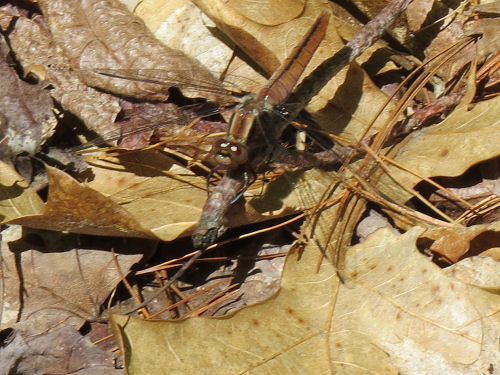
The air was alive with medium-sized brown dragonflies. They would zoom by at my shoulder level or a little lower, and then perch down low on sticks and things near the ground. I caught one in focus. I'm no dragonfly expert, but I think this is a Common Baskettail. The pattern isn't quite right, but the behavior and the time of year are correct. Also, the fuzzy thorax, and the little bit of darker color where the hind wings join the body. Another new dragonfly for me!

common baskettail dragonfly

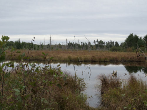
There's a nice wetland you can see on the last loop I took. It's at the edge of Syers Lake. I went closer to take a picture. Do you see anything interesting?

Syers Lake wetland Pine Valley Pathway

There's a bald eagle coming right at me!

bald eagle flying

He (it's big- so probably she) perched in a tree, and I got a picture, but there are too many pine needles in the way. But look at that foot!

bald eagle

On the way home in the car I may have seen the same eagle, and much more closely, but I couldn't get a picture while driving. It and a crow were getting an early dinner on a road killed deer. They were actually sharing.

In other news: I wrote in the morning, and then did this hike. Now I'm fed and clean and hope to do a little bit of bookwork yet tonight.

Pine Valley Pathway, 10 miles, Lake County, Michigan, Pere Marquette State Forest
Pine Valley Pathway

See Pine Valley Pathway Again
See Briar Hill from Hodenpyl Dam Pond
if you like this blog, click

Like This!

Monday, October 8, 2018

Day Twenty-Two - Midland to Mackinac

 
Jumped the gun a little on the ending of the rain. Oh well. I walked in hard rain for an hour, but then things cleared up and the rest of the day was beautiful and warm.

Made it past the community of Aloha, and Aloha State Park.

Aloha Michigan town garden

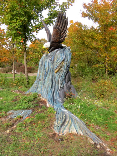
This beautiful carving done in a stump is at the entrance to the park. Look at how even the roots are painted.

eagle carved into a tree stump

The trail swings by the shores of Mullett Lake, which is really large. After the rain cleared it was quite warm, so mist was rising from everywhere. It made the water and sky all swirl together, even with a distant shoreline.

Mullett Lake

I just liked this interesting little fungus on the end of a log.

brown fungus

In one place a large swath of white cedar needles had fallen across the trail. The pattern is fascinating.

white cedar needles

Finally, both "tunnel" pictures I took today are inviting, with the sun shining through wet leaves. I think I like the first one better, but each has a unique feel.

rail trail with sunny leaves

rail trail with sunny leaves

My feet aren't crazy about these 14-mile days on the hard surface. Actually, the feet as a whole are fine, but the two toenails I'm losing are sore tonight. Neither one is quite ready to fall off yet.

People must have been waiting to pounce on a nice afternoon. By the time I turned around and started back, there were power boats on the lake, a kayaker, a bicyclist on the trail and another walker on the trail. She said she saw me go by her house in the rain on the way out.

kayaker

Looks like the weather is going to cooperate tomorrow, but Wednesday may be a complete washout. I'm not walking in thunderstorms. We'll see what the sky actually produces. I'd like to try to pick up a bit of that missing section on the way home on Friday, but it has hardly stopped raining since the day the roads were flooded before. Probably, they haven't improved.

Forward progress: another 7 miles. Total miles walked today: 14 again. Total trail miles to date: 179. I haven't added up the total miles walked yet. I'll do that later.

See Day Twenty-One
if you like this blog, click the +1   or

Like This!


Sunday, September 30, 2018

Day Fourteen - Midland to Mackinac

 
Today was awesome! I made eight miles of forward progress. I am loving the wild and remote feel of this area. Miles and miles of evergreens and aspen always with a low ridge in sight in the distance. That said, the woods is full of guys in trucks and Jeeps and on ATVs scouting out places to hunt. I find it a bit hilarious how often I'm getting passed by vehicles on these nothing roads.

northeast Michigan backcountry

I particularly liked this little stretch on the "Wannabuk" Trail. For one thing, the footing was solid. In the picture above the M2M followed a snowmobile route that is all churned up sand. Who knew I should have trained for this hike by walking the beaches?

northeast Michigan backcountry

But the trail turned off Wannabuk in that band of jackpine you can see above. It took me an hour to do the next mile and a half. It was back to bushwhacking with blazes, and then a stretch where I would never have found my way except there was a bit of a treadway to follow. Crossed some mucky areas that could be bad in spring, and a small creek that is part of the headwaters of the West Branch of Big Creek. Little log bridge. I ate lunch there with the water gurgling.

log bridge

Then a large beaver pond where there would be some nice camping spots.

beaver pond

It was a good day for tracks. That soft sand took prints very well. I'm getting up in the area where the Michigan Elk Herd is located. Pretty sure I saw elk tracks both yesterday and today.

elk tracks

Most of the usual suspects: deer, raccoon, fox (of course it could have been a dog, but there were no accompanying human tracks), and maybe a bobcat. Kicking myself for not taking pictures of that. Sandhill crane, not too unusual, but fun.

sandhill crane tracks

The weather was perfect for hiking. I think it got a little warmer than they predicted, but about 50 degrees all day. My little thermometer broke just before this trip so I've had to guess. So I decided to try to get in a pile of miles. Pretty sure I got in 8 trail miles. But I had no particular interest in going back through that difficult stretch or repeating the 5 miles is soft sand, so I decided to walk other roads back. What a great choice!

There is an area along the Middle Branch of Big Creek that I thought was beaver flooding, but I later learned it was dammed to create a long skinny lake. Made that walk quite enjoyable.

I saw a pair of trumpeter swans.

trumpeter swans

And then I watched an eagle swoop down and catch a fish.

bald eagle

Trail miles total: 109- over half by any estimation. Miles walked today: about 14.

Today's trail angel is named Clayton. I still had 3.5 miles to go to the car. I had it in me to do them, but didn't like how late that got me back, because I had a motel reservation waiting (the shower felt great and now the wet tent is drying over the rod). A guy in a Jeep stopped and asked if I was walking for fun or wanted a ride. I said I'd gotten my trail miles in for the day and would be glad of a ride. Turns out Clayton is a member of the outdoor club where Luke "Strider" Jordon spoke this past week about his Great Plains Trail hike! Small world, right?

Weather looking bad tomorrow afternoon. I think I'll do a short hike in the morning, and then come back and go to the laudromat and hardware store.

Did I mention how still it was today? Many, many times I could hear no human sounds at all. No breeze. Just quiet!

See Day Thirteen
if you like this blog, click the +1   or

Like This!