Entries to Win Afghan

Sign up to receive the Books Leaving Footprints Newsletter. Comes out occasionally. No spam. No list swapping. Just email me! jhyshark@gmail.com Previous gifts include a short story, a poem, and coupons. Add your name, and don't miss out!
Showing posts with label creek. Show all posts

Saturday, April 13, 2024

Heritage Nature Trail - Cadillac

 After the vendor event today, I took a short hike on the Heritage Nature Trail at Mitchell State Park in Cadillac. I had been there once before in 2015 (link below).

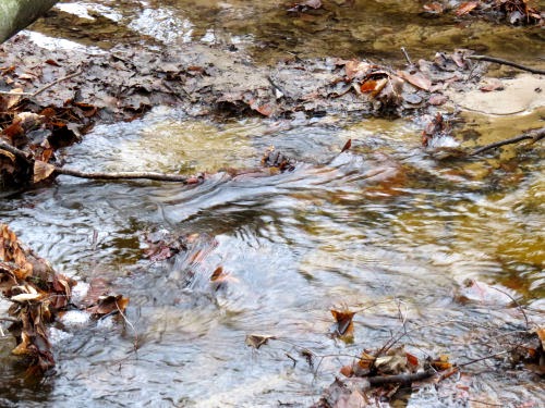
This is a large man-made wetland area between Lakes Mitchell and Cadillac. Black Creek, seen here, used to be used to float logs between the two lakes, but it was too shallow, and a canal was eventually dug. This changed the hydrology of the area enough that this became about 70 acres of wetland.
black creek cadillac


Since it's now preserved as a nature study area, that is a good thing. Most of the trail is in the form of a raised berm that goes in a rectangle around the area. At least it's dirt. But despite being close to two busy highways, it's known for great wildlife viewing. There is a spur into the middle of the marsh with an observation platform. I went out there, but it's pretty early to see much. There were a couple of slow peepers.

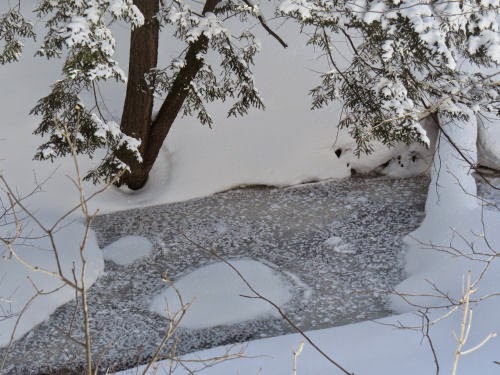
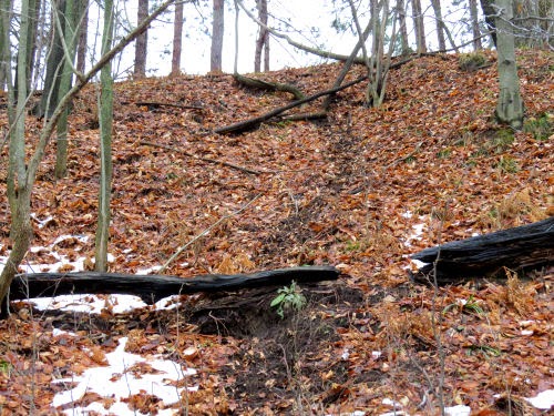
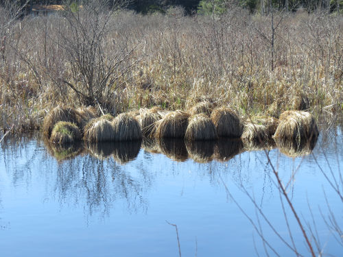
I really liked this collection of hummocks along the diverted section of Black Creek that surrounds the wetland.
hummocks


Saw my first turtles of the year! Just painted turtles, but that's OK. I like to play the game of "which will be first?" Some years it's been a Blandings.
painted turtles


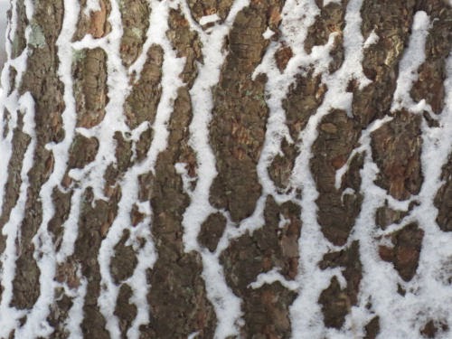
I wanted to take the outer loop, and I did. But the cut-across loop was so attractive, I had to walk it too (both directions, eh?). It goes over what they call "hemlock island." Since nobody was keeping any kind of records when this land was all changed, they don't really know why it's higher, or why (uncharacteristically) hemlocks are growing that near a wetland. But it was a beautiful section of trail. Two humps with hemlocks, and one lower section with a boardwalk through the marsh.
trail in hemlocks


On the walk back, I cut over to Lake Cadillac.
lake cadillace


The willow trees are getting all sexy. This is goat willow, Salix caprea, alien. But the male catkins sure are fancy.
goat willow catkins


With the extra bits of trail I did and the out and back pieces, I managed to turn it into a four mile walk. There is lots of interpretation, and would be a nice walk with kids. Probably you'd see a lot of wildlife activity on a summer evening.

The vendor event went OK. They didn't manage to pull in a very good crowd. I sold a few books and talked with a lot of people. But a few of my friends came. Sorry, no picture of Miki, but I finally got a pretty good one of Eamon!


Total miles hiked in 2024: 193.6 of which 69.6 is North Country Trail.

Mitchell State Park, Cadillac, MI, Heritage Nature Study Trail. with spurs. 4.0 miles

See Sunday Hikes

Saturday, February 24, 2018

Memory- Points to Hold

 
Yesterday, you saw some of the changes happening across the road from me. Today, I learned that a favorite tree of mine has been cut down. Yeah, it was geriatric and probably dangerous, but I liked it. A few days ago I shared an aerial view of our previous house here, which is now gone. The dorm I lived in for my college years is gone. The first two houses Omer and I lived in are gone- one demolished and one burned (neither of those when we were still living there).

I know that nothing in this world lasts, or even really matters. And yet, I feel a strong connection with the house I grew up in, the one my grandfather built. If something happens to it, I'm going to feel a true sense of loss, even though the barn is gone, the property is sold several times over, and my dad's garden is now a workshop and swimming pool.

Pulled this off Google Street View, so I'm pretty certain that unless something serious has happened quite recently, the house is still there.

Craftsman bungalow house

Here's the house when I lived in it (picture about 1962).

Craftsman bungalow house

Still amazingly like- the wood shingled porch has been kept and the white paint. I have to wonder how the inside has been changed though. I've heard some things about the beautiful woodwork, so I have no interest in being granted an interior tour.

The maple that creates a shadow on the left side of the roof in the older picture is gone, but the catalpa, just leafing out in the old picture- left of the house, is now completely dominating that side. I did a lot of jumping out of that tree, and stringing of tarp tents between it and the missing maple.

Some of my favorite trees from that era are also gone. They might be a tale for another day. Today, I'll just show you the Google view farther north of the house.

The line of trees and bushes are along the unnamed and seasonal creek. You can see the culvert going under the road. From the road on downstream for probably fifty feet was (is?) a stone sluiceway in which I used to play. Below that was a small almost-pond. I actually could swim in it in the spring- well, I could get wet and splash a lot. Below that was where I went fishing in my new rubber boots. The tree with a reddish cast is the hybrid cherry where my swing and treehouse were.

line of trees beside a creek

There are some places where I desire change and crave new experiences. I think my houses is not one of those. Although much of my childhood was not particularly happy, I love that house. Odd, eh? Thanks for taking this journey with me.

In other news: wrote chapter 13 in The ABZ Affair.

See Sunshine Bungalove
See the fishing picture
if you like this blog, click the +1   or

Like This!

Saturday, April 2, 2016

Spirit of the Woods Hike - April 2016

 
Wow! 21 people (and 3 dogs) showed up for the hike today. Only one group cancelled out because of the snow. As it turned out the weather was great and the woods were beautiful. The predicted wind didn't kick up till after I was safely home, and the temperature was just above freezing.

hikers

We hiked the North Country Trail from 76th St to 96th St, which is the section through Sterling Marsh. The water was high, and we really appreciated the boardwalks. There were still some soggy spots, but before the boardwalks you never would have been able to walk this section in spring without getting totally wet feet.

You've seen Jenks Creek in summer. It was really pretty today with the fresh and clingy snow.

Jenks Creek

The busiest hiker, by far, was and always is Lily the beagle. She is a beagle's beagle and has to explore every hole and log and nook and cranny. However, I actually managed to catch her without her nose poked into somewhere.

beagle

At this time of year, Sterling Marsh is really a pond. This piece has some open water all year, but you'll only see it like this in spring. This is the location of the interesting curled reeds.

Sterling Marsh

We've had a number of new people at our recent hikes, which is a lot of fun. It's great to make new friends who enjoy hiking. With such a large group we quickly broke into smaller confabs. I ended up in the rear because the group took off gung-ho while I was still putting my tripod away. That was fine. I chatted with Bob and Patti (Lily's humans), which was nice because I don't see them too often. We caught up with these guys who were getting acquainted.

hikers

I had to try an artsy shot, right? The shallow water made great reflections.

reflection

Miles toward the 100-mile challenge added, 4.1. Good times? Immeasurable. Ability to stay awake any longer when I got home? None.


See Hiking in Hemlock Lace
if you like this blog, click the +1   or

Like This!


Friday, January 1, 2016

Sinuous

 
A visit to the cemetery creek is always interesting. It's a short, unnamed rivulet, but it runs all year.

This week, it's been cold enough to freeze the edges, and islands of debris, and cover them with snow but not cold enough to still the water.

I just liked the shapes formed by those smooth white edges.

partially frozen creek

partially frozen creek

Lots of changes there- a few trees blown down, two big ones marked for removal because they are nearly dead, a pump house where water used to be pulled from the creek has fallen in. One change that happened decades ago has always made me sad. Perhaps I'll make it a blog post one of these days.

I work tonight, but not too long. We did much of Friday night's usual work early this week because of the holiday.

See How's the Cemetery Creek
if you like this blog, click the +1   or

Like This!


Wednesday, October 14, 2015

Blue Water

 
Had to do a few cases after the paper job today. Bright and crisp with blue, blue water.

First is the creek, whose name I cannot discover on any map, including the USGS topo map, which feeds the Middle Bayou of Hamlin Lake. Loving the primary colors!

Middle Bayou Creek

But the view of Hamlin Lake from Long Skinny Park was pretty amazing. Those are the bare Hamlin dunes in the background.

Hamlin Lake

See Hamlin Dunes
See Snow on Hamlin Dunes
if you like this blog, click the +1   or

Like This!


Sunday, February 15, 2015

After the Storm

 
It was so still and beautiful today, after the winds of yesterday, that I just had to go out. I confess that I only did about a half-hour snowshoe walk, but even so, it was awesome.

The report from the deck is that all the critters are fine. Riley was racing around early, and the birds followed. This little junco is not frozen in place, but seems solidly settled.

junco

The Cemetery Creek is frozen. No surprise there, but the scattered fluffy snow on the surface is interesting.

frozen creek

Finally, just two interesting patterns of light and dark.

shadows on snow

snow on bark

We had pancakes for lunch... a perfect meal on a cold day.

if you like this blog, click the +1   or

Like This!


Sunday, November 30, 2014

How's the Cemetery Creek?

 
Today I decided to walk down to the creek. I used to go there nearly every day with Maggie (except in winter- it's too steep to snowshoe). I confess I haven't done as many daily walks since she's been gone. Also, there is a big tree down across my path and it's going to be a lot of work to cut it out.

Cemetery Creek

But, today I worked my way down to the creek. It has no name, and it's only a couple of miles long. I've taken you to the headwater marsh (and learned it's covered in poison ivy, so that's not a good summertime walk). I've followed it to the Pere Marquette River, but it goes through a lot of private property, so I only did that once. And it was before I started blogging.

At any rate, it has water year round, and it's close to home, so I enjoy it. We had a strong warm wind last night so are nearly snowless again. The creek is a little ripple of brown across a sandy bottom nestled in the orange-brown leaves.

Cemetery Creek

The deer sure aren't either good trail builders or environmentalists. Their trail just plunges straight down the bank. I took a more angled route across the face of the gully.

deer trail

This is my favorite shot of the day- a scalloped edging on a patch of ice.

ice edge

See The Midwinter Visit to the Cemetery Creek
if you like this blog, click the +1   or

Like This!


Wednesday, July 30, 2014

The Grand and the Intimate

 
Worked some for both jobs today and then went out checking sites for Get Off The Couch. Discovered that a trail which has been closed (as in gated) for a couple of years is now open again. From the top of the pumped storage reservoir you can see the Ludington Lighthouse, and the beginning of the channel. The big point of land is Big Sable Point, where the tall striped lighthouse I've showed you a few times is located. The picture is taken at about 950 feet, and the lake surface is about 580. Not bad for a "flat" state.

Ludington Michigan

On an intermediate scale, Kibby Creek rest area is located on... duh... Kibby Creek. It's a pretty little stream. Here a tiny rill is adorned with forget-me-nots.

Kibby Creek

Just to keep us up to date, the caterpillars have migrated to other plants, but look! A few of them have gone to instar 4. It's amazing how few have made it that far from the mass we started with. Probably some I can't see any more are fine, but even so, the mortality rate even without being eaten is high.

milkweed tussock caterpillar

And! The one we want to see, the Monarch caterpillar, was back this morning. Literally back... that's his tail end.


monarch caterpillar

The cool summer has even made the papers here. I'm sure liking these temperatures.

See Caterpillar Surprise
if you like this blog, click the +1   or

Like This!


Sunday, June 15, 2014

Fourth Hiking Day- May 26- Beaverkill Rd to Wildmeadow Rd.

 
This was an easy hiking day, only 6.5 miles and lightly rolling. It was the last day of the Finger Lakes Trail hike that would be all off road, and we really enjoyed it. I guess the theme of the day was "color."

Our first stream crossing was over Black Brook. With the dark stones the name actually seemed sensible (although the next stream was Mexico Creek. It did not look southwestern).

Black Brook

This leaf seems to be a novelty. It's a red raspberry that appears to have no chlorophyll.

red raspberry

This was closely followed by cute little orange fungi.

orange fungus

This connected us to the place where we'd done a section of road walk two days previous.

Catskill map
Then we made a decision that turned out to be a good idea.

Because of our changed plans, this hike had morphed into five days instead of four. There was still one day to go. And I was supposed to write my monthly news column and send it in by Tuesday noon. There was plenty of time to accomplish the writing; we finished this walk early in the afternoon on Monday. We found a place to eat and get internet access in Claryville (more on that another day). I couldn't move the deadline because I'd already made arrangements to send it later than they like to have copy. It would be easy enough to "fudge" the text and make it sound like we'd finished, but I wanted a picture of us at the eastern terminus of the trail.

It seemed like it would be anticlimactic, but we went to the end of Denning Road, and hiked the final mile of trail that connects the Finger Lakes Trail to the Long Path (not to be confused with the Long Trail). The Long Path goes from New Jersey to near Albany.

Long Path logo

Somehow, it was just fine. I often get bent out of shape about endings that aren't endings (I try not to get grouchy), but this time, it seemed like a perfect ending to the last off-road day of the hike. We would just knock out those remaining road miles the next day in good time and scoot in the cars for Marie's house. I signed the register book... it was a nice touch to be able to write "completing the Finger Lakes Trail."

Black Brook

And so, here we are at the eastern end of the FLT, and it was exciting and exhilarating and emotional. I'll add this final 1.2 miles to the map for tomorrow. So this day's total was 8.9 (of which 7.7 counted- since we did the final piece in two directions).

Finger Lakes Trail eastern terminus

This has turned into way too many pictures for one post, but I have to show you that we are a long way from the western terminus, both in space and time. This picture is from 2000. It's the only state to state crossing on the NCT that is all on trail with a sign. So, there are the brackets for my Finger Lakes Trail!

NY PA border

See Third Hiking Day
if you like this blog, click the +1   or

Like This!