So, I started the day by walking a short piece that ended at Craig Lake. Two miles in on a "road" walk, I reached Long Lake.

Oops! Perhaps the beavers have plugged the culvert. But whatever happened, the road is completely flooded with the lake on one side and the outfall creek on the other. Got out the plastic bags! The trail turns into the woods just beyond here. Easy to find, but I had to get there.

As I approached Craig Lake (you can just see the water in the background), look who walked out to meet me! It's always fun to find Sue and the puppers looking for me.

And here we are at Craig Lake. This is considered to be one of the most remote state parks in Michigan. It has lots of walk-in campsites, and the lake, of course. Being able to drive in has made it possible for me to hike another section without having mileages that are too long. There were almost no trees down on this section. That's really good news, because a lot of serious blowdowns would slow me too much to make the miles.

Then we jumped ahead to see if we could cut a couple of miles off the other end of that piece. This is the place where I declined to hike just a few days ago because of the snow and downed trees. Just to get the statistics out of the way, a work crew had managed to clear about 0.5 miles of the 1.7 I walked here. In the remaining 1.2 miles, I counted 70 significant trees down across the trail. Even so, I managed to average about 45 minutes a mile. I've hiked worse! (see Ohio in the ice storm).
But there were also some nifty rocks in this section. I loved the orange icicles on this rock face that is right beside the trail.

In a little stream, I found upside-down ice mushrooms. Actually, I thought this was pretty interesting, because they are about the same shape as birch polypore (and some other polypores). This suggests to me that this is a natural fractal growth pattern that occurs under certain conditions.

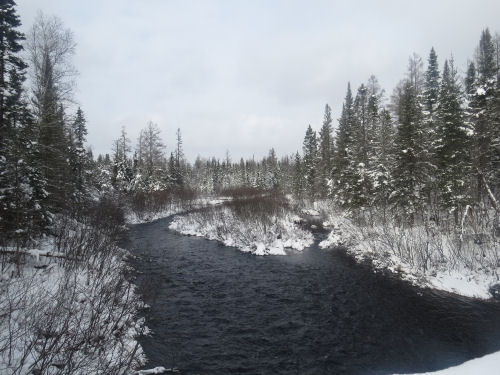
And here is my goal for the day. This is the west end of McCormick Wilderness. From here, it's already too late to get any access for the next 20 miles. I'll probably have to backpack this with someone. The middle access to this section is where Sue and I were trying to get to on Plan B last Friday. I'm standing on the Peshekee River bridge (vehicles not allowed) at the entrance to the McCormick.

And here's the river. This river actually flows south, eventually to Lake Michigan. Even though its source is only about 10 miles from Lake Superior, that is high in the Huron Mountains, and it runs down to Lake Michigamme and then to the Menominee River which empities into Green Bay.
Lots of logistics today to do the two small pieces, but I got good information on difficulites. Tomorrow, I'm filling in a 9.7 mile piece, but I'm pretty confident that I can do it.
Miles today: 6.4. Total miles so far: 4084.7.
 | See Huge Kudos to Sue |
1 comment:
Lulu: "You are unstoppable! And so are those little dogs, hiking in snow that's deeper than they are tall!"
Post a Comment