These loops are really beautiful and also challenging. The dunes are steep-sided. Especially this one. Dune, you ask? Yes, these are stabilized and forested sand dunes. Typical of the area.

On the new-to-us piece of trail we followed today, there are some long arms of water "lost" from Hamlin Lake. In this one, the farthest V of water you can see is the main body of the lake.

Pretty soon we arrived at a familiar intersection, and now we know just what to do to go north to the shore of Hamlin Lake. Here's that familiar scene again. There's ice farther out now although it's not solid enough for ice fishing yet.

From there, we know how to return, but we are still a bit puzzled about what we did on our first walk, since there's a section we didn't find today, or two weeks ago, either. But we think we have identified the junction where the trail to Inspiration Point joins. We'll check that out another day. The trail mostly follows ridges rather than going down to the bottoms of the valleys, but it's still quite hilly. In the snow, this was a pretty good workout.

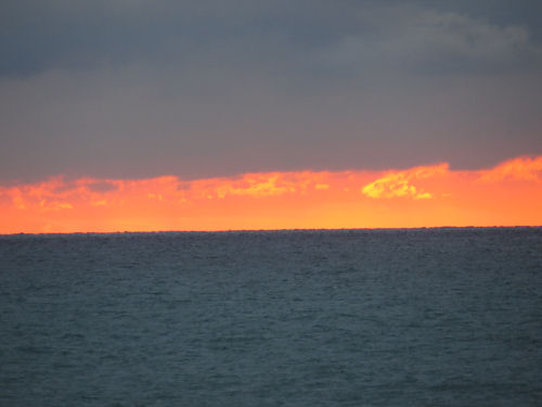
When we got back to the car, at the turn on Lakeshore Drive, the sunset was a long thin orange-pink line low on the horizon. This is a terrible picture, but it shows how far across our view the pink extended, so I'm sharing it.

We turned toward it and stopped at one of the parking turnouts. Even though it isn't what I'd call spectacular, it seems unusual with that single bright band below the clouds.

I zoomed in on the brightest spot. It realy looks like flames in there! Well, I guess it is, since the sun is a huge fireball. (Although that has to just be illuminated clouds.)
3.75 miles, and it was a really good workout walking in the previously tracked snow!
In other news: I edited in the morning.
Ludington State Park, unmarked trails between Piney Ridge Road and Hamlin Lake. 3.75 mile loop
 | See An Adventure with Cathy |
3 comments:
You two are doing good at figuring out these trails.
Charlee: "Maybe it's one of those magic trail systems where parts of it only appear on certain days at certain times and one of them goes to like Shangri-La?"
Lulu: "Those kind of trails only exist in stories."
Chaplin: "If you think that way you're never going to find them."
Ann- we sure are, and I'm mapping them with a trail app now
Chaplin- I think you are on to something.
Post a Comment